Height (quarter)
|
Höhe (37) district of Wuppertal |
|
|---|---|
| Coordinates | 51 ° 13 '6 " N , 7 ° 3' 49" E |
| height | 260 m above sea level NHN |
| surface | 1.22 km² |
| Residents | 5394 (December 31, 2016) |
| Population density | 4421 inhabitants / km² |
| Proportion of foreigners | 21.5% (December 31, 2016) |
| Post Code | 42329 |
| prefix | 0202 |
| Borough | Vohwinkel |
| Transport links | |
| bus | 621 631 683 NE1 NE23 |
| Source: Wuppertal statistics - spatial data | |
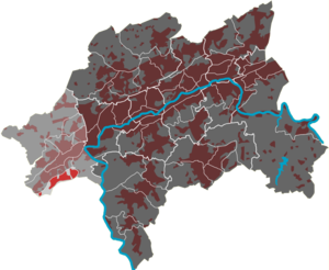
The Wuppertal residential area Höhe is one of nine districts in the Vohwinkel district .
history
Höhe is an old place name used by several farms in the area: Unterste or Küppers Höhe, Schäfers Höhe, Rauen Höhe, Engels- or Oberste Höhe.
Until the beginning of the 19th century, the farms belonged to the Oberste Honschaft Haan in the Bergisch Amt of Solingen . They belonged to the parish of Haan and came to Vohwinkel in 1894, which was united with Elberfeld and Barmen to Wuppertal in 1929.
Description of the current residential area
The tubular, 1.22 km² residential area is heavily populated and is enclosed in the north by the federal motorway 46 and in the south by the border with the neighboring city of Solingen . In the east it borders on the forest area Klosterbusch of national forest castle wood . The district is divided into two parts by the north-south running Gräfrather Straße, the area Engelshöhe - Elfenhang - Höhe in the west and Roßkamper Höhe - Dasnöckel (Nöckel or Nockel, formerly used for hills) in the east. The first residential buildings were erected in the early 20th century along Gräfrather Strasse and on Höhenweg, which today, as Strasse Höhe, forms the east-west axis of the district. Most of the land north of this street was built on in the 1970s, largely through public housing in multi-storey blocks and high-rise buildings. In between there are some newer single-family house areas and with the Bracken / Bies area, a partially tree-lined meadow around some old manors. The south-eastern tip of the quarter is used commercially; in addition to a food market, the Bergische Krematorium is also located here .
The population structure shows a particularly high proportion of younger residents; at the end of 2005 the rate of under 21-year-olds was the highest in Wuppertal at around 30%. The proportion of residents with a migration background is also the highest in the urban area at 56.6% in the group of residents up to the age of 27. These include a particularly large number of immigrants from Eastern European and former states of the Soviet Union. Around 17% of the population are Muslim. In 2006 around a quarter of the population up to 65 years of age received unemployment benefit II . Due to this population structure and the lack of appropriate social offers, especially for young people, the district is considered a social hotspot that is in the special focus of urban development. There is little business in the quarter, but it is well supplied by local retail chains. In the quarter there is a primary school, a youth center and a youth traffic school.
The Bolthausen water tank was an important element of the Wuppertal drinking water supply in the residential area . The Roßkamper Höhe water tower is striking .
Web links
- City of Wuppertal: Framework Concept Quartier Höhe, 2007 ( PDF , 173 kB)
Individual evidence
- ↑ Oberste Honschaft Haan on www.zeitspurensuche.de, accessed February 2010
- ^ The problem areas of the city of Westdeutsche Zeitung from April 9, 2008


