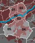
Elberfeld (city district)
|
Elberfeld (0) District of Wuppertal |
|||||||||||||
|---|---|---|---|---|---|---|---|---|---|---|---|---|---|
| Coordinates | 51 ° 15 '26 " N , 7 ° 8' 57" E | ||||||||||||
| height | 140- 326 m above sea level. NHN | ||||||||||||
| surface | 11.07 km² | ||||||||||||
| Residents | 65,645 (Dec. 31, 2014) | ||||||||||||
| Population density | 5930 inhabitants / km² | ||||||||||||
| Proportion of foreigners | 22.7% (Dec. 31, 2014) | ||||||||||||
| politics | |||||||||||||
| Allocation of seats (district representation) | |||||||||||||
|
|||||||||||||
| Transport links | |||||||||||||
| Highway |
|
||||||||||||
| Federal road |
|
||||||||||||
| railroad | RB 48 RE 4 RE 7 RE 13 IC ICE | ||||||||||||
| Train | S 7 S 8 S 9 | ||||||||||||
| Local transport | Suspension railway | ||||||||||||
| Source: Wuppertal statistics - spatial data | |||||||||||||
Elberfeld is a district of Wuppertal and corresponds to the expanded historical center of the old town of Elberfeld . Together with the districts of Elberfeld-West and Uellendahl-Katernberg , it forms the Elberfeld district.
geography
Division in the district
|

|
North city
The Mount of Olives is part of the Elberfelder Nordstadt .
Culture and sights
The borough has some of the oldest church buildings in the city, including the Old Reformed Church and the Old Lutheran Church. Important church buildings of the 19th century are the Catholic Laurentiuskirche from 1835, the New Reformed Church (1858) and the Friedhofskirche (1898). A richly furnished historical building from the turn of the century is the historic town hall on Johannisberg , the town's concert hall. The Von-der-Heydt-Museum , an important art museum in the Rhineland, is also located in Elberfeld. The natural history Fuhlrott Museum was closed in 2008. The theater of the Wuppertaler Bühnen and the Rex Theater are also located in the district. Listed sports facilities are the stadium at the zoo from the 1920s and the so-called swimming opera from the 1950s.
Web links
- Sights in Wuppertal-Elberfeld ( Memento from December 5, 2012 in the web archive archive.today ) by Wolfgang Mondorf
- Virtual city tour through Wuppertal-Elberfeld
See also
- List of architectural monuments in the Elberfeld district of Wuppertal
- Elberfeld Bible - a Bible translation created between 1855 and 1871


