Barmer Mühlengraben
| Barmer Mühlengraben | ||
|
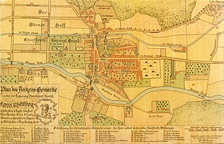
The center of Barmen (district) around 1761 with the mill ditch still open, there called Mühlenstrang |
||
| Data | ||
| Water code | DE : 273651316 | |
| location | Wuppertal , North Rhine-Westphalia , Germany | |
| River system | Rhine | |
| Drain over | Wupper → Rhine → North Sea | |
| origin | Tee off from the Wupper in Wupperfeld between Brändströmstraße and Pfälzer Steg 51 ° 16 ′ 26 ″ N , 7 ° 12 ′ 42 ″ E |
|
| Source height | 159 m above sea level NN | |
| muzzle | On Loher Strasse in the Wupper Coordinates: 51 ° 16 '2 " N , 7 ° 10' 54" E 51 ° 16 '2 " N , 7 ° 10' 54" E |
|
| Mouth height | 152 m above sea level NN | |
| Height difference | 7 m | |
| Bottom slope | 2.6 ‰ | |
| length | 2.7 km | |
| Catchment area | 4.818 km² | |
| Big cities | Wuppertal | |
|
The Mühlengraben on Loher Strasse |
||
|
Tributaries and hydraulic structures
|
||||||||||||||||||||||||||||||||||||||||||||||||||||||||||||||||||||||||||||||||||||
The Barmer Mühlengraben is a 2.66 kilometer long, almost completely rotten moat in the center of the Wuppertal district of Barmen .
Location and course
The Barmer Mühlengraben branches off to the right of the Wupper at a weir in the Wupperfeld district between Brändströmstrasse and the Pfälzer Steg and immediately disappears into a doldrums . Below the residential development, it flows through the inner city of Barmen, receives a flow from the Westkotter Bach, flows briefly above ground level with the Wuppertal brewery and disappears again in a hollow at the town hall of Barmen and crosses its newer administrative wing.
After it has flowed past the Bergische Synagoge and the Gemarker Church , it receives a flow from the Leimbach . Then he crosses under the Steinweg , the Church of St. Antonius , the Christ Church , further residential buildings and the comprehensive school Barmen .
There the ditch comes to the surface twice briefly and flows back into the Wupper in the district of Loh in Unterbarmen below the suspension railway station Loher Brücke .
history
The Mühlengraben, the exact time of its creation, is of medieval origin. Research assumes that the ditch was initially a natural side or dead arm of the Wupper, which was expanded into an upper and lower ditch of the Barmer mill , first mentioned in 1336 . The Barmer mill was one of three ducal ban mills in the Beyenburg office , to which Barmen belonged between 1399 and 1806, and was located at the level of today's Bergische Synagoge.
The Barmer line of the Bergische Landwehr crossed the Mühlengraben at the level of the Alter Markt .
On the grounds that aufspannte between the sidearm and the Wupper, were the 1466 first mentioned Hofschaften Dorner Hof (ducal Oberhof Barmen) and Werth . As a toponym for a river island, the name "Werth" describes the location of the farm between the two watercourses. From the 16th century the village of Gemarke developed on the border between the two courts , the center of the settlement of the later city of Barmen.
Until the end of the 19th century, the Mühlengraben flowed almost completely above ground, then as Barmen grew into an industrial city, it was increasingly built over with commercial operations and above all residential buildings.
Todays situation
The Mühlengraben only has water in the initial area when the water level in the Wupper is high. In the wastewater concept of the city of Wuppertal, it is primarily used as a receiving water and collector for rainwater . Therefore, the water feature was officially revoked in 2005 from the beginning to the Bachstrasse .
literature
- Walter Dietz: Barmen 500 years ago an investigation of the Beyenburger official accounts from 1466 and other sources on the early development of the place Barmen (= contributions to the history and local history of the Wuppertal. Volume 12). Born-Verlag, Wuppertal 1966.
- Gerd Helbeck : Beyenburg - history of a place on the Bergisch-Mark border and its surrounding area. Volume I: The Middle Ages: Fundamentals and Advancement. Association for local history Schwelm 2007, ISBN 978-3-9811749-1-5 .
Web links
Individual evidence
- ↑ a b German basic map 1: 5000
- ↑ a b FlussGebietsGeoinformationsSystem of the Wupperverband (query on November 13, 2010)
- ↑ Public announcement of the city of Wuppertal from May 25, 2006: Partial abolition of the water quality of the Mühlengraben water body (PDF; 532 kB).

