Mercy
|
Oberbarmen (6) district of Wuppertal |
|||||||||||||||
|---|---|---|---|---|---|---|---|---|---|---|---|---|---|---|---|
| Coordinates | 51 ° 17 '4 " N , 7 ° 13' 21" E | ||||||||||||||
| height | 156- 320 m above sea level. NHN | ||||||||||||||
| surface | 12.57 km² | ||||||||||||||
| Residents | 43,245 (Dec. 31, 2014) | ||||||||||||||
| Population density | 3440 inhabitants / km² | ||||||||||||||
| Proportion of foreigners | 21.8% (Dec. 31, 2014) | ||||||||||||||
| politics | |||||||||||||||
| Allocation of seats (district representation) | |||||||||||||||
|
|||||||||||||||
| Transport links | |||||||||||||||
| Highway |
|
||||||||||||||
| Federal road |
|
||||||||||||||
| railroad | RE 4 RE 7 RE 13 RB 48 | ||||||||||||||
| Train | S 7 S 8 | ||||||||||||||
| Local transport | Suspension railway | ||||||||||||||
| Source: Wuppertal statistics - spatial data | |||||||||||||||
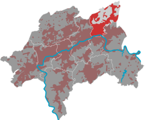
Oberbarmen is a district of Wuppertal . It was formed when several cities and towns were united to form the city of Wuppertal in 1929 from the Barmer districts of Wupperfeld , Wichlinghausen , Rittershausen and Nachbarebreck .
geography
Division into quarters
|

|
history
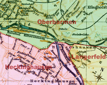
The division of Barmen into Oberbarmen and Unterbarmen is based on ecclesiastical boundaries: Before the Reformation , there was no parish of its own in the Barmen area, the area west of the Alter Markt belonged to the parish of Elberfeld in the Deanery Neuss, the area of Barmen-Gemarke and further east to the parish Schwelm in the dean's office in Lüdenscheid. The creeks Leimbach north and Fischertaler Bach south of the Wupper formed the border. This division was also retained when the parishes around the Wichlinghauser Church and the Old Church of Wupperfeld were founded, which were independent of Schwelm . The present-day district of Heckinghausen as well as the quarters of Barmen-Mitte (originally a district) and Sedansberg , but not next-out, also belong to the historical Oberbarmen .
Wupperfeld
The area of today's Wupperfeld was more heavily populated in the 18th century, the inhabitants were called "Wupperström". The settlement was promoted by the construction of a Lutheran church approved by the elector in 1777 , which was put into service in 1781 - still unfinished. The Wupperströmers split off from the previously responsible parish in Wichlinghausen, which fought the new church as fiercely as the original mother community in Schwelm . As a result of the flourishing yarn weaving at the time, a patch quickly formed around the church which was named Wupperfeld after the field on which it was created. With industrialization in the 19th century, Wupperfeld grew together with the district and Rittershausen to form the urban core of the city of Barmen. Today it is still the name of a suspension railway station and forms the western part of the Oberbarmen-Schwarzbach district. The church music activities achieved national and even international fame: on the one hand through the Barmen-Gemarke Kantorei at the Immanuelskirche and on the other hand at the Old Church Wupperfeld through the Wupperfeld Abendmusiken , the Wupperfelder Kantorei , the C-music training center of the Rhineland Regional Church and as a music college location . In addition, the Carl-Duisberg-Gymnasium was located here for over a century , the main building of which is now a listed building.
Rittershausen
The core of the old Rittershausen was a courtyard that was mentioned in 1466 as Riddershoff, i.e. as a supply courtyard for the knight's seats. The associated field name was van des Ridders Hus and was located at the mouth of the Schwelme in the Wupper . The Rittershaus family, who run the farm, is documented for the first time in 1594, and the poet Emil Rittershaus also came from them . A village formed around the courtyard, which in 1821 had grown to around 1,300 inhabitants. In the following decades Rittershausen grew together with the neighboring towns to form the city of Barmen. In 1863 the Rittershausen train station was inaugurated, which gave Rittershausen the railway connection to Wuppertal. In 1868 a railway line was opened via Lennep to Remscheid , which led from the newly built Remscheid train station on the Wupperufer through Heckinghausen. A route to Hattingen and the Wuppertal Railway followed. With the construction of the Wuppertal Railway, rail traffic from Remscheid was also routed via Langerfeld , and the Remscheid railway station became superfluous. In 1903, Rittershausen finally became the eastern terminus of the Wuppertal suspension railway . The name of the district was given up when Elberfeld was merged with Barmen in 1929 and Rittershausen (together with Wupperfeld) was renamed Oberbarmen. Here it forms the eastern part of the Oberbarmen-Schwarzbach district. The train stations now also bear the name Wuppertal-Oberbarmen . Large parts of the village to the south and east of its center fell to the districts of Heckinghausen and Langerfeld-Beyenburg.
Next brace

Next Breck is to the north of the urban area of Wichlinghausen and Langerfeld and lies on three heights rising to the north, separated by stream valleys. The central elevation is the approx. 300 meter high next Brecker mountain, on which the eponymous 'Braken' is located. At the highest point in the east is a modern water tower .
Some farms such as Einern , Bruch and Haarhausen are oldest mentioned in the area of Nachbarebreck in the 11th and 12th centuries . In the following centuries several other farms around the area called Braken (now Bracken) are mentioned. In 1324 the rural area fell to the County of Mark , so it is Westphalian.
In 1486 Nebenebreck is first mentioned as a rural community with 14 local farmers. In 1614, next bridge fell to Brandenburg-Prussia . The south-western border of Brecker is now the state border between the (Rhenish) Duchy of Berg and Brandenburg-Prussia.
In 1922 Nebenebreck is incorporated into the city of Barmen together with Langerfeld, which in 1929 merges into the city of Wuppertal , whose history it has shared since then. In 1970, during the municipal reorganization, the courtyards and residential areas of Blumenroth, Erlenrode, Uhlenbruch and Schmiedestrasse were transferred from the Ennepe-Ruhr district to Next Breck.
See also
literature
- Fritz Mehnert (ed.): Oberbarmer community history. Evangelical parishes district-Wupperfeld, Wuppertal 2002.
- Wilhelm Rogge: The community of Wupperfeld. A picture from the evangel. Church of the Rhineland. Wiemann, Barmen 1877. Digitized


