Bendahler Bach
| Bendahler Bach | ||
|
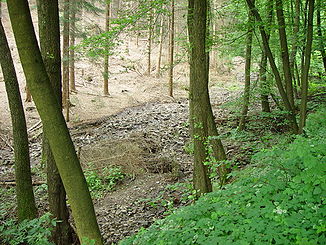
The Bendahler Bach in the middle reaches at low water |
||
| Data | ||
| Water code | DE : 273651342 | |
| location | Wuppertal , North Rhine-Westphalia , Germany | |
| River system | Rhine | |
| Drain over | Wupper → Rhine → North Sea | |
| source | At Wuppertal- Lichtscheid 51 ° 14 '38 " N , 7 ° 10' 46" E |
|
| Source height | 296 m above sea level NN | |
| muzzle | At the court island in the Wupper coordinates: 51 ° 15 ′ 28 ″ N , 7 ° 9 ′ 48 ″ E 51 ° 15 ′ 28 ″ N , 7 ° 9 ′ 48 ″ E |
|
| Mouth height | 154 m above sea level NN | |
| Height difference | 142 m | |
| Bottom slope | 59 ‰ | |
| length | 2.4 km | |
|
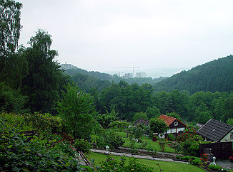
View along the Bendahler Bachtal, in the middle the head office of Barmenia Insurance |
||
|
The valley of the Bendahler Bach, seen from the Nützenberg |
||
|
Tributaries and hydraulic structures
|
||||||||||||||||||||||||||||||||||||||||||||||||||||||||||||
The Bendahler Bach is a 2.44 kilometer long brook in the Elberfeld district of Wuppertal . The brook, a tributary of the Wupper , is at the same time the namesake for a Wuppertal district and for the former correctional facility Bendahl .
topography
The stream rises in a spring pond at a height of 319 meters near a residential area on Böhler Weg . A second pond immediately afterwards with a concrete weir was drained in the 1980s. The headquarters of the Barmer GEK and the Bergische Sonne leisure pool are located on the nearby mountain top of Lichtscheid . A pipe connects the stream with the area of the leisure pool, through which sewage was discharged into the stream at the time of the earlier tram and bus depots before the pool was built.
It continues above ground in a northerly direction along a wooded valley that the stream has created over time. The Böhler Weg follows the stream downhill on the left. After about one kilometer, the 481 meter long Böhler Bach flows into the Bendahler Bach on the left. Around 300 meters further, the 480-meter-long Böhlerhofer Bach also flows from the left . After 30 meters it continues piped, past the outdoor pool of the Wasserfreunde Wuppertal and a pond.
This pond is the renatured remnant of the large and popular Bendahl outdoor pool , whose basin was fed by the stream. The outdoor pool had walls lined with concrete, but a natural floor made of mud . In the second half of the 20th century, such an underground was no longer closed and the outdoor pool was therefore closed. In the late 1980s, it was dismantled into a small park with a pond. The low-rise building, which is also part of the outdoor swimming pool, is now used as a scout home by the Wuppertal Boy Scout Association . The boy and girl scouts try to keep the house through donations and voluntary initiative.
Further down, the stream emerges from an industrial park to the side of a parking lot, only to run again after another 200 meters. The Böhler Weg merges into Bendahler Straße and the brook changes sides. Now the Bendahler Bach runs to the left of this street. At the height of the intersection of Bendahler Strasse and Wolkenburg , the 780-meter-long tubed brook flows into the Bendahler Bach on Buschstrasse . Shortly thereafter, the brook crosses the Elberfeld – Dortmund railway line and the 7 (B 7) federal road . The Wuppertal correctional facility was formerly located there , and the Wicküler brewery on the other side .
In the vicinity of the largest inland island of the Wupper, the judicial island, the brook flows into the Wupper regional court in the left branch of the Wupper at around 154 meters above sea level .
The valley of the Bendahler Bach
Today's Böhler Weg along the Bendahler Bach comes from a connecting road from the Furter Hof via Schuwanstraße , In der Böhle , Dausendbusch to Gockelsheide . This street was designed in 1754 by the engineer and captain Mansfeld, who was also responsible for the construction of the Chaussee between Elberfeld and Barmen, today's Friedrich-Engels-Allee , from 1750 to 1752 , and expanded it as Elberfelder Communalweg in 1848.
Along the valley, higher than the Bendahler Straße and Böhler Weg , the well-developed state road 417 (L 417) also runs Ronsdorfer Straße . It creates an important connection road from the Elberfeld center to the heights and on to the Ronsdorf district . In addition to the Barmer GEK on the Lichtscheid, the Barmenia Insurance has its headquarters here in the valley. In 2006/2007, Barmenia significantly expanded its administrative premises by adding three more tall buildings (not yet visible in the lower picture opposite).
The brook as a historical borderline
In the late Middle Ages, the Bendahler Bach separated the Bergisch offices of Beyenburg and Elberfeld . To secure this border, a section of the Elberfeld line of the Bergische Landwehr ran on the west side of the brook .
Older names
First mentioned in 1466
The first documentary mention of the settlement and the forest on the brook comes from a Beyenburg official bill from 1466. There, the taxes of the Barendahl farm in the valley and the rights of use of the farm in the ducal forest, the Boele , are determined.
1609
On an Elberfeld district map (1609) by Johann von der Waye , the brook has several names depending on the section. In the upper reaches before junction of today's Böhler Bach today is Bendahler Bach as Boehler Sieffe (cf .: Siepen called), today Böhler Bach contrast than Laßsieffe or in the upper reaches Laßype . From the confluence, today's Bendahler Bach was also called Laßsieffe .
Today's Böhlerhofer Bach was called Kotzsieffe . From its confluence, the name of today's Bendahler Bach changed to Vorderbeck ( Beck is an old name for Bach, Vorder may be a form of ford and refers to the Wupperfurt near the Further Höfe at its mouth).
After crossing under the old road from Barmen to Elberfeld , the stream was named Vurderbeck . It is not clear whether the change from Vorderbeck to Vurderbeck was a typographical error or, as in many other texts of the time, an exact spelling was generally not considered important. The Vurderhöffe zu Ibbert estate was located at the mouth of the brook in the Wupper on the site of today's electronics store . Since there was a Wupperfurt there, the name of the farm probably derives from this Wupper crossing. The names of the farms later changed to Further farms .
1715
According to the Topographia Ducatus Montani by Erich Philipp Ploennies around 1715, the Bendahler Bach was also called Capellenbach . The name probably comes from the Hofschaft Capell, which is located near Lichtscheid near the spring (at J. vd Waye: Capeller Höffe , also mentioned as a chapel in 1466). The place name Capell lives on in the Kapellen district today .
At Ploennies, the old Barendahl farm in the valley is now called Pandahl . An etymological connection between Barendahl , Pandahl and Bendahl can be assumed.
Individual evidence
- ↑ a b German basic map 1: 5000
- ↑ River Area Geoinformation System of the Wupper Association (FluGGS Wupper)
- ^ Karl Coutelle : Elberfeld, topographical-statistical representation ; Elberfeld; 1853


