Glüder
|
Glüder
City of Solingen
Coordinates: 51 ° 8 ′ 2 ″ N , 7 ° 7 ′ 11 ″ E
|
||
|---|---|---|
| Height : | 85–200 m above sea level NN | |
| Postal code : | 42659 | |
| Area code : | 0212 | |
|
Location of Glüder in Solingen |
||
Glüder is a locality in the independent Bergisch city of Solingen in North Rhine-Westphalia .
Location and description
The location mentioned in 1633 (Hofschaft) belongs to the municipality of Burg / Höhscheid and is located in the south of the urban area on the border with Leichlingen opposite the confluence of the Sengbach and Hammersbach in the Wupper valley at an altitude of 85 to 90 meters above sea level .
District road 4 runs through the village and connects Solingen across the Wupper to the Leichlinger district of Witzhelden . The facilities in Glüder include a campsite and a mini golf course , and a fairytale forest used to be located here. The former country inn with dance hall housed the Getaway disco from 1979 to 1992 and is now empty again after being used as an excursion restaurant.
Several marked hiking trails run through Glüder, such as the Klingenpfad , Wupperweg , Schlösserweg and Landrat-Lucas-Weg . Local hiking trails lead to the neighboring sights and hiking destinations such as Castle Castle , Sengbachtalsperre , Balkhauser Kotten or the Rüdenstein .
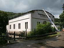
The municipal waterworks located a few hundred meters upstream is also named after Glüder. It treats surface water from the Sengbach reservoir and pumps it into the municipal drinking water network as drinking water. The associated turbine house on the Wupper houses a run-of-river power station and another turbine that is fed from the bottom outlet of the Sengbach dam.
The animal welfare association Bergisch Land eV has been operating the Solingen animal shelter close to the waterworks since 1974 .
Glüder is one of the water level measuring points on the Wupper.
Just a few hundred meters to the southeast is located in the forest, the ring wall Heide Keller , one as a cultural monument designated Wallburg .
history
Glüder originally only consisted of a farm south of the Wupper in the area of the parish and the Witzhelden Honschaft in the Bergisch Amt Miselohe . The map Topographia Ducatus Montani from 1715 shows the farm under the name Glüder , not a settlement but in today's Solingen area north of the Wupper. The Witzheldener Glüder south of the Wupper existed until the 20th century with residential houses and a grinding dome on the Sengbach. The topographical survey of the Rhineland from 1824 and the first Prussian survey from 1844 show settlement areas on both sides of the Wupper, the larger in each case in the Solingen city area today. The Kaiserskotten am Sengbach is also marked on both. The part north of the Wupper belonged in the 19th century to the Balkhausen honors first in the Solingen court of the Bergisches Amt Solingen , then to the Dorp mayor .
In 1815/16 eleven residents lived in the Witzhelden part of Glüder, compared to 21 in the Dorper part. In 1832, the part of Glüders south of the Wupper belonged to the Witzhelden parish of the Burscheid mayor , the part to the north continued to belong to the Dorp mayor. The places categorized as Hofstadt according to the statistics and topography of the administrative district of Düsseldorf both had seven residential buildings at that time (three for Witzhelden, four for Dorp), one Schleifkotten (for Witzhelden) and twelve agricultural buildings (five for Witzhelden, seven for Dorp) . At that time, 36 residents lived in the village (eleven in Witzhelden, 25 in Dorp), all of whom were Protestant.
Due to the municipal code for the Rhine province, the parish of Witzhelden received the status of a municipality in 1845, left the Burscheid mayor and formed its own mayor's office from 1850 onwards . In the municipality lexicon for the Rhineland province in 1885, two houses with 13 inhabitants are given for the Witzheldener Glüder, and seven houses with 34 inhabitants for the Dorper.
In 1889 the mayor's office in Dorp was incorporated into the city of Solingen and the part of Glüder north of the Wupper came to Solingen. In 1895 the Witzhelden part of Glüder owned a house with two residents, the Solingen part six houses and 28 residents. In 1905, two houses and 26 inhabitants are given for the Solingen Glüder, no more information is recorded for the Witzheldener Glüder, as all the buildings in the Witzheldener Glüders were closed with the construction of the Sengbach dam.
Due to the Düsseldorf law , the municipality of Witzhelden was incorporated into the city of Leichlingen by surrendering the area around the Sengbach dam in Solingen. The former settlement area of the Witzheldener Glüders came into the Solingen city area.
Individual evidence
- ↑ Glüder waterworks
- ^ State Office for Nature, Environment and Consumer Protection in North Rhine-Westphalia. In: luadb.it.nrw.de. September 20, 2019. Retrieved October 22, 2019 .
- ↑ Johann Georg von Viebahn : Statistics and Topography of the Administrative District of Düsseldorf , 1836
- ↑ Königliches Statistisches Bureau (Prussia) (Ed.): Community encyclopedia for the Rhineland Province, based on the materials of the census of December 1, 1885 and other official sources, (Community encyclopedia for the Kingdom of Prussia, Volume XII), Berlin 1888.
- ↑ Königliches Statistisches Bureau (Prussia) (Ed.): Community encyclopedia for the Rhineland Province, based on the materials of the census of December 1, 1895 and other official sources, (Community encyclopedia for the Kingdom of Prussia, Volume XII), Berlin 1897.
- ↑ Königliches Statistisches Bureau (Prussia) (Ed.): Community encyclopedia for the Rhineland Province, based on the materials of the census of December 1, 1905 and other official sources, (Community encyclopedia for the Kingdom of Prussia, Volume XII), Berlin 1909.

