
Theegarten
|
Theegarten
City of Solingen
Coordinates: 51 ° 10 ′ 34 ″ N , 7 ° 6 ′ 40 ″ E
|
||
|---|---|---|
| Height : | about 200 m | |
| Postal code : | 42651 | |
| Area code : | 0212 | |
Location of Theegarten in Solingen |
||
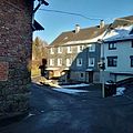
 Half-timbered house in Theegarten
|
||

Theegarten is a court in the mountainous city of Solingen .
geography
Theegarten is located on the edge of a hilltop in the east of the Solingen district of Mitte . The place is at the extreme end of Theegartener Straße east of Kannenhof and north of Meigen , which lies on the banks of the Meigener Bach . Altenbau is located north of Theegarten , where the Städtgesmühler or Papiermühlenbach runs in a wooded creek valley . The Wupper flows to the east, and there is a paper mill on the banks of the river . The Halfeshof and Windfeln are located south of Theegarten .
history
Theegarten may have existed as early as the 14th century. In 1303 documents mention a Henrich van Zeyngarden , so Zeyngarden could be today's Theegarten. Secured is the mention of the place for the year 1488, when he was a Tegarden in Zehntregister the Monastery Altenberg is mentioned. In the map series Topographia Ducatus Montani by Erich Philipp Ploennies , Blatt Amt Solingen , from the year 1715, the place is recorded with a farm and named as Degarten . The court belonged to the Honschaft Solingen within the office of Solingen. The topographical survey of the Rhineland from 1824 lists the place as the Theegarten and the Prussian first survey of 1844 also as the Theegarten. In the topographic map of the Düsseldorf administrative district from 1871, the place is again listed as Theegarten .
After the establishment of the Mairien and later mayor's offices at the beginning of the 19th century, Theegarten belonged to the Dorp mayor's office . In 1815/16 95 people lived in the hamlet called Theegarten , and in 1830 107 people . The place, categorized as a Hofstadt according to the statistics and topography of the administrative district of Düsseldorf , had 18 residential houses, three factories or mills and nine agricultural buildings in 1832. At that time 123 residents lived in the place, eight of them Catholic and 115 Protestant denominations. The municipality and manor district statistics of the Rhine Province list the place in 1871 with 20 houses and 124 inhabitants. In the municipality lexicon for the Rhineland province of 1888, 20 houses with 118 inhabitants are given for Theegarten .
The mayor's office or city of Dorp was merged with the city of Solingen in 1889. This made Theegarten a district of Solingen. In 1895 the district had 16 houses with 88 inhabitants, in 1905 16 houses and 98 inhabitants are given.
After the Second World War, a Friends of Nature House was built in Theegarten and opened in 1954. The house is still today owned by NaturFreunde Deutschlands , local group Solingen-Theegarten e. V., managed.
Today, the forests and meadows around Theegarten are made accessible by numerous hiking trails, including the so-called Theegartener Kopf . This is a viewing platform that was built in the course of the construction of the mountain railway line from Theegarten down to Müngsten . The mountain railway route as the former route of the Ronsdorf-Müngstener railway and the plateau at Theegartener Kopf were redesigned until summer 2010 with funds from the Regionale 2006 .

View of Theegarten
Houses in Theegarten

Houses in Theegarten


Web links
swell
- ↑ Hans Brangs: Explanations and explanations for the corridor, place, yard and street names in the city of Solingen . Solingen 1936
- ^ City of Solingen: Street and place names in our city of Solingen , self-published, Solingen 1972
- ^ Topographic map of the Düsseldorf administrative district . Designed and executed according to the cadastral recordings and the same underlying and other trigonometric work by the Royal Government Secretary W. Werner. Edited by the royal government secretary FW Grube. 4th rev. Edition / published by A. Bagel in Wesel, 1859 / Ddf., Dec. 17, 1870. J. Emmerich, Landbaumeister. - Corrected after the ministerial amendments. Ddf. d. Sept. 1, 1871. Bruns.
- ↑ a b Johann Georg von Viebahn : Statistics and Topography of the Administrative District of Düsseldorf , 1836
- ↑ Friedrich von Restorff : Topographical-statistical description of the Royal Prussian Rhine Province , Nicolai, Berlin and Stettin 1830
- ↑ Royal Statistical Bureau Prussia (ed.): The communities and manor districts of the Prussian state and their population . The Rhine Province, No. XI . Berlin 1874.
- ↑ Königliches Statistisches Bureau (Prussia) (Ed.): Community encyclopedia for the Rhineland Province, based on the materials of the census of December 1, 1885 and other official sources, (Community encyclopedia for the Kingdom of Prussia, Volume XII), Berlin 1888.
- ↑ Königliches Statistisches Bureau (Prussia) (Ed.): Community encyclopedia for the Rhineland Province, based on the materials of the census of December 1, 1895 and other official sources, (Community encyclopedia for the Kingdom of Prussia, Volume XII), Berlin 1897.
- ↑ Royal Statistical Bureau (Prussia) (Ed.): Community encyclopedia for the Rhineland Province, based on the materials of the census of December 1, 1905 and other official sources, (Community encyclopedia for the Kingdom of Prussia, Volume XII), Berlin 1909
- ^ ADFC Solingen-Wuppertal: Solingen Mountain Railway. Retrieved January 21, 2017 .
Altenbau | Stop cap | Arnsberger Kotten | Auer Kotten | I. Balkhausen | II. Balkhausen | III. Balkhausen | Balkhauser Kotten | Mug house | Amber house | Bertramsmühle | Bilsteiner Kotten | Birch trees | Birmingham | Buck | Böckerhof | Breidbach | Bünkenberg | Dornsiepen | Dorperhof | Eichholz | Eick | Elsterbusch | Heir house | Donkey | Eulswag | I. field | II. Field | III. Field | IV. Field | Rock cellar | Fleußmühle | Glüder | Grünental | Grunenburg | I. Hästen | II. Chesting | III. Hate | Hip | Height | Hohenscheid | Irlen | Jagenberg | Kannenbrühl | Kannenhof | Kempen | Kirberg | Kirchbaumshöh | Kirchbaumskotten | Kirchberger Kotten | Klauberg | In the Klauberg | To Klauberg | Königskotten | Königsmühle | Kohlfurth | Crow height | Linden tree | Mouse height | Meigen | Meigenerbrühl | Meisenburg | Obendahl | Obenweeg | Odental | Paper mill | Papiermühlerbach | Pereskotten | Petersmühle | Pfaffenberg | Potshaus | Schaberg | Soundbreak mill | Switch caps | Scharfhausen | Schellberg | Schlicken | Schrodtberg | Schützenfeld | Schützenhöhe | School bushes | Backlash break | Städtgesmühle | Stone sieving | Sticks | Stöckerberg | Strohnerbach | Storm hole | Fir tree | Theegarten | Unnersberg | Downhill | Vockert | Vockerterbusch | White horse | Werewolf | Wieden | Wiedenhof | Wiesenkotten | Diapers | Windfelnerhof | Desert farm