Staderhof
|
Staderhof
City of Leichlingen (Rhineland)
Coordinates: 51 ° 6 ′ 35 ″ N , 7 ° 0 ′ 30 ″ E
|
||
|---|---|---|
| Height : | 77 m above sea level NN | |
| Postal code : | 42799 | |
|
Location of Staderhof in Leichlingen (Rhineland) |
||
|
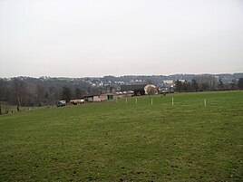
View of Staderhof
|
||
Staderhof is a court and former manor in the town of Leichlingen (Rhineland) in the Rheinisch-Bergisch district .
Location and description
Staderhof is located in the north-west of Leichlingen above the Wupper on the orographic right bank of the river, but outside of the closed development of the core town. To the north are the village of Ziegwebersberg and the Müllerhof estate .
Neighboring places, mostly those in the western suburbs of Leichlingen, are Pastorat , Windgesheide , Stockberg , Am Adler , Merlenforst , Hüttchen , Scheeresberg , Kaltenberg , Brückerfeld , Brücke , Bockstiege and Bahnhof . On the other side of Wuppers are the places Am Hammer , Eicherhof Castle and the historic Leichlinger town center with the Protestant church.
The courtyard complex with a two-storey, late-classicist house (built in 1912) under a crooked hip roof and a lintel of the manor in the stables from 1792, which was demolished in 1911, are listed as historical monuments .
history
Staderhof was first mentioned in 1327 and was a manor. The name is probably derived from the location on the Wupper, see the shores .
The map Topographia Ducatus Montani from 1715 shows a Freihof under the name Stadenhof . In the 18th century, the place belonged to the parish of Leichlingen in the Bergisches Amt Miselohe . The topographical survey of the Rhineland from 1824 and the Prussian first survey from 1844 both list it as Staderhof , as does the Leichlinger municipality map from 1830.
In 1832 Staderhof belonged to the mayor's office of Leichlingen under the name Staderhoff . Which according to the statistics and topography of the district of Dusseldorf as Ackergut categorized place had at this time a house and a farm building. At that time, 11 residents lived in the village, one of them Catholic and ten Protestant. In 1867 the Gruiten – Cologne – Mülheim railway line was opened west of Staderhof .
In the municipality lexicon for the Rhineland province in 1885 a house with seven inhabitants is given. In 1895 the place had a house with nine inhabitants, in 1905 one house and seven inhabitants.
The manor house was built in 1792 and was demolished in 1912 in favor of a late Classicist house built in 1912. At the end of the 20th century, the Staderhof was used as a horse farm. In 2008 a barn burned down in the yard. The horse industry was replaced by fruit growing in 2013.
Individual evidence
- ↑ Staderhof on www.geschichte-leichlingen.de. Retrieved April 28, 2015 .
- ↑ Johann Georg von Viebahn : Statistics and Topography of the Administrative District of Düsseldorf , 1836
- ↑ Königliches Statistisches Bureau (Prussia) (Ed.): Community encyclopedia for the Rhineland Province, based on the materials of the census of December 1, 1885 and other official sources, (Community encyclopedia for the Kingdom of Prussia, Volume XII), Berlin 1888.
- ↑ Königliches Statistisches Bureau (Prussia) (Ed.): Community encyclopedia for the Rhineland Province, based on the materials of the census of December 1, 1895 and other official sources, (Community encyclopedia for the Kingdom of Prussia, Volume XII), Berlin 1897.
- ↑ Königliches Statistisches Bureau (Prussia) (Ed.): Community encyclopedia for the Rhineland Province, based on the materials of the census of December 1, 1905 and other official sources, (Community encyclopedia for the Kingdom of Prussia, Volume XII), Berlin 1909.


