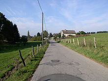
Krähwinkel (Leichlingen)
|
Crowing angle
City of Leichlingen (Rhineland)
Coordinates: 51 ° 6 ′ 51 ″ N , 7 ° 5 ′ 58 ″ E
|
||
|---|---|---|
| Height : | 192 m above sea level NN | |
| Postal code : | 42799 | |
|
Location of Krähwinkel in Leichlingen (Rhineland) |
||
|
View from Oberkrähwinkel
|
||
Krähwinkel is a village in the town of Leichlingen (Rhineland) in the Rheinisch-Bergisches Kreis, consisting of several residential areas .
Location and description
Krähwinkel is east of the center of Leichlingen on the western edge of the hill village of Witzhelden in the upper reaches of the am Weltersbach , which is also called Krähwinkeler Bach or Holzerbach here. Krähwinkel consists of several separate settlement areas, of which the eastern Oberkrähwinkel near the source of the Weltersbach is the oldest. Unterkrähwinkel is west of the stream, the other residential areas are located south on the other side of the stream up to the L294 state road and are mainly used as farms for agricultural purposes. The Abspliss Neukrähwinkel is a residential area with single-family houses.
In addition to Witzhelden , other neighboring towns are Sieferhof , Schüddig , Wilhelmstal , Metzholz , Schneppenpohl , Krabbenhäuschen , Bechhausen , Heeg , Herscheid , Flamerscheid , Claasholz and Oberbüscherhof .
The Witzhelden transmitter is located above Krähwinkel .
history
The name Krähwinkel is derived from the animal species crows , Krähwinkel means crow's corner . The Topographia Ducatus Montani map from 1715 shows four courtyards under the name Schüddig at the place of Oberkrähwinkel and two unlabeled courtyards on the old high road from Witzhelden to Leichlingen, today's state road. Unterkrähwinkel and the other living spaces are not shown there. In the 18th century, the place belonged to the parish Witzhelden in the Bergisches Amt Miselohe . The topographical survey of the Rhineland from 1824 shows, in addition to the Ober- and Unterrähwinkel, three other places to live and all of them are labeled as Krähwinkel. The Prussian first recording from 1844 differs in the inscription in Obr. Kräwinkel and Untr. Crowing angle .
In 1815/16 there were 144 people living in the village. In 1832 Krähwinkel belonged to the parish Witzhelden of the mayor's office of Burscheid . The place, categorized as a village according to the statistics and topography of the administrative district of Düsseldorf , had 29 houses, a factory or mill and 60 agricultural buildings at that time. At that time, 156 people lived in the village, three of them Catholic and 153 Protestant.
Due to the municipal code for the Rhine province, the parish of Witzhelden received the status of a municipality in 1845, left the Burscheid mayor and formed its own mayor's office from 1850 onwards . In the municipality lexicon for the Rhineland province in 1885, 51 houses with 215 inhabitants are given. In 1895 the place had 49 houses with 206 inhabitants, in 1905 43 houses and 170 inhabitants.
On January 1, 1975, the municipality of Witzhelden was incorporated with Krähwinkel in Leichlingen.
Individual evidence
- ↑ Johann Georg von Viebahn : Statistics and Topography of the Administrative District of Düsseldorf , 1836
- ↑ Königliches Statistisches Bureau (Prussia) (Ed.): Community encyclopedia for the Rhineland Province, based on the materials of the census of December 1, 1885 and other official sources, (Community encyclopedia for the Kingdom of Prussia, Volume XII), Berlin 1888.
- ↑ Königliches Statistisches Bureau (Prussia) (Ed.): Community encyclopedia for the Rhineland Province, based on the materials of the census of December 1, 1895 and other official sources, (Community encyclopedia for the Kingdom of Prussia, Volume XII), Berlin 1897.
- ↑ Königliches Statistisches Bureau (Prussia) (Ed.): Community encyclopedia for the Rhineland Province, based on the materials of the census of December 1, 1905 and other official sources, (Community encyclopedia for the Kingdom of Prussia, Volume XII), Berlin 1909.
- ^ Federal Statistical Office (ed.): Historical municipality directory for the Federal Republic of Germany. Name, border and key number changes in municipalities, counties and administrative districts from May 27, 1970 to December 31, 1982 . W. Kohlhammer, Stuttgart / Mainz 1983, ISBN 3-17-003263-1 , p. 298 .


