
Duisburg-South
|
|||
|---|---|---|---|
| coat of arms | map | ||

|

|
||
| structure | |||

|
|||
| Basic data | |||
| Area : | 49.84 km² | ||
| Residents : | 73,123 (December 31, 2018) | ||
| Population density : | 1,467 inhabitants / km² | ||
| Postcodes : | 47249, 47259, 47269, 47279 | ||
| Telephone code : | 0203 | ||
| Distribution of seats for the district council (2014) | |||
|
|||
Duisburg-Süd is the southernmost and with 49.84 km² the largest urban district in the city of Duisburg . It has 73,123 inhabitants ( as of December 31, 2018 ). It has existed as a city district since January 1, 1975.
The city district consists of the former Klevian council village of Wanheim-Angerhausen and otherwise only former Bergische districts, which were incorporated into Duisburg in 1929 and a small part only in 1975 and previously belonged to the Angermund district in the Düsseldorf district .
Duisburg-Süd borders in the north on the Duisburg district of Duisburg-Mitte , in the east on the city of Mülheim an der Ruhr , in the south on the city of Düsseldorf and the district of Mettmann . The Rhine separates the city district in the west of Duisburg-Rheinhausen and the cities of Krefeld and Meerbusch . The Angerbach flows through the district . At Mündelheim a language border, the so-called Uerdinger line or Ik-Ich line, crosses the Rhine.
The district mayor is Beate Lieske (SPD).
structure
The district comprises the following city and district parts:
- Bissingheim
- Buchholz
- Great Tree
- Huckingen
- Huettenheim
- Mündelheim with the districts of Ehingen , Rheinheim , Serm and Holtum
- cream
- Ungelsheim
- Wanheim-Angerhausen
- Wedau
The route of the Cologne-Mindener Railway and the A 59 motorway divide the district into a western and an eastern half. While the northwest of the district is characterized in particular by the steel industry in Hüttenheim, the Huckinger Mark, an old forest area, with the recreation and leisure area Sechs-Seen-Platte runs through the east . The south of the district is partly still used for agriculture and is characterized by the partly still village structures of Mündelheim, Serm and Rahm.
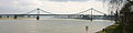
Rhine Bridge Uerdingen - This bridge connects Krefeld-Uerdingen with Duisburg-Mündelheim

Local recreation and excursion destination: The Masurensee in Wedau

St. Anna Hospital in Huckingen

Catholic Church St. Hubertus in Rahm
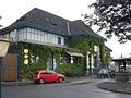
Old Grossenbaum station, now a music café


Architectural monuments
See list of architectural monuments in Duisburg-Süd .
Web links
- District website
- District Office South ( Memento from March 10, 2007 in the Internet Archive )
- Map of the borough at OpenStreetMap
Individual evidence
- ↑ Population statistics of the city of Duisburg from December 31, 2018
- ↑ WAZ article on the election of Beate Lieske
Aldenrade | Old town | Baerl | Beeck | Beeckerwerth | Bergheim | Bissingheim | Bruckhausen | Buchholz | Dellviertel | Duissern | Fahrn | Friemersheim | Großenbaum | Alt-Hamborn | Hochemmerich | High field | Hochheide | Homberg | Huckingen | Hüttenheim | Kasslerfeld | Laar | Marxloh | Meiderich | Mündelheim | Neudorf | Neuenkamp | Neumühl | Obermarxloh | Overbruch | Cream | Rheinhausen-Center | Röttgersbach | Ruhrort | Rumeln-Kaldenhausen | Ungelsheim | Old Walsum | Vierlinden | Wanheim-Angerhausen | Wanheimerort | Wedau | Wehofen
Coordinates: 51 ° 23 ' N , 6 ° 46' E