
Historic Holzwickede mining circuit


The historic Holzwickede mining trail , also known simply as the Holzwickede mining trail , is a hiking trail in Holzwickede . The circular route is approx. 17 kilometers long and can be used as a pedestrian or cyclist.
Stations
The mining circuit leads clockwise along 27 stations and 14 information boards provide explanations of the local mining history.
- In the Emscherpark there is an overview sign with the history of the mining history of the hard coal mining in Holzwickede.
- Today's Villa Pfiffikus (youth home) is a former administration building of the Caroline mine .
- Next to Villa Pfiffikus is the former entrance to the coal mine Caroline with an information board.
- There is an information board at the site of the former Freiberg colliery . Today the factory of VW Werke Vincenz Wiederholt is located here .
- In the middle of the air shaft path is the former air shaft of the Margarethe colliery with an information board.
- On Emscherquellhof during mining activity sprang from the Emscher . Due to mining in the Hixterwald, the Emscher, which originally rises there, dried up in the 19th century and came to light again here at the Emscherquellhof. Today the Emscher rises again in the Hixterwald.
- Gottfried Köhling, who was a shift supervisor at the Schwarze Adler colliery in the 1830s and 1940s, lived in the house at Landskroner Strasse 161 . He was also responsible for selling coal. Opposite in the Hixterwald was the Gumprecht mine shaft, which was leveled in 1845 after the colliery was closed.
- At the beginning of the southern forest path into the Hixterwald there is an information board about the Schwarze Adler colliery .
- Pingen can be viewed in the Hixterwald . These are round, funnel-like depressions that follow the course of the coal seams.
- There are also large depressions from a former sandstone quarry in the Hixterwald in the headwaters of the Emscher.
- In a front garden at the end of the street “Im Schwarzen Adler” there is a boundary stone of the “Neue Schwartze Adler Zeche”. The stone originally stood elsewhere.
- On the strand of hair between the Landskrone and Hengsen you can see in good visibility in the north as far as Cappenberg Castle and in the south as far as Iserlohn .
- In Opherdicke there is an information board at the former quarry opposite the Opherdicke house on Schlossallee.
- On the way from Opherdicke back to Holzwickede there is an information board about the Joseph Kleinzeche
- A detour up the Hengser Weg leads to the location of the former Carlsbank colliery with an information board.
- In the valley of the Holzwickeder Bach the path leads through the Schöne Flöte. At the beginning of the forest there are tracks of the horse carts that brought the coal from the shafts on Massener Straße to the south ( Schwerte and Iserlohn ).
- A little further to the left of the path is an old mine dump from the Caroline colliery from 1856 with material from the two inclined shafts on Massener Straße.
- The next station in the Schöne Flöte is an information board that indicates the artificial moat. Here the Holzwickeder Bach was straightened and canalized in order to use water power to pump the water out of the tunnel below.
- You can also discover pinging at the Holzwickeder Bach. These are collapse funnels of shafts from the time after 1800 from the Caroliner Erbstollen .
- Another information board explains the artificial shaft through which water was pumped from the Caroliner tunnel below.
- At the exit of the path along the Holzwickeder Bach there is an information board at the former light hole 18 of the Caroliner Erbstollen.
- About a kilometer further north is the mouth of the Caroliner Erbstollen with an information board. The tunnel entrance can be visited here.
- The Schulzenhof is located on Massener Straße past the Natorper mill. At the beginning of the 20th century, the farm belonged to VEW , which also owned the Caroline mine. In the 1930s the courtyard was presented to the public as a fully electrified model courtyard.
- Just south of the Hilgenbaum there is an information board on Massener Straße to commemorate the light hole 17 of the Caroliner Erbstollen.
- A little further on, an information board reminds of the ton-long (sloping) shafts Caroline I / II.
- Opposite the information board was the horse-drawn tram, which from 1857 led from here to the Holzwickede-Unna railway line. The loading platform was located on the current site of the Montanhydraulik company .
- The last stop before returning to Emscherpark is a weather shaft of the Caroline mine northeast of the intersection of Opherdicker Straße / Hamburger Allee. The air used in the pit was extracted from the 58 m deep shaft. The shaft was in operation from 1886 to 1904 and was then leveled.
Picture gallery
The following pictures show the information boards at some stations on the circular route.
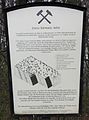
Black Eagle Colliery (Station 8)

Opherdicke quarry (station 13)
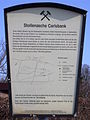
Karlsbank Stollenzeche (Station 15)

Caroline Wasserkunst (Station 18)
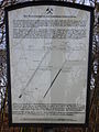
Art shaft (station 20)

Light hole 18 (station 21)

Oral hole of the Caroliner Erbstollen (station 22)

Light hole 17 (station 24)

Caroline Schächte (Station 25)


literature
- Leaflet of the Holzwickede working group of the Friends of Mining Historic Sites Ruhrrevier eV
Web links
Coordinates: 51 ° 30 '2.6 " N , 7 ° 37' 2.4" E
Mining hiking trail Muttental | Germany Mining Trail | Mining hiking trail Alte Haase north and south | Herzkämper-Mulde-Weg | Pleßbachweg | Montanweg North | Mining hiking trail Bochum-Süd | Mining Trail Ruhr University | Mining hiking trail Baak | Mining Trail Dahlhausen | Mining hiking trail Wattenscheid | Historical mining circuit Holzwickede | Bergbauwanderweg Wetter | Schlebusch way | Neuwülfingsburger Weg | Erbstollenweg | Syburger Bergbauweg
Visitor center and anchor points (from west to east): Museum of German Inland Shipping | Inner harbor Duisburg | LVR Industrial Museum Oberhausen | Landscape Park Duisburg-Nord | Gasometer Oberhausen | Aquarius Water Museum | St. Antony Hut | Villa Huegel | Nordsternpark | Zeche Zollverein World Heritage Site and Zollverein Coking Plant | Ewald colliery | Marl Chemical Park | Railway Museum Bochum-Dahlhausen | Henrichshütte | Centennial Hall Bochum | Recklinghausen substation | German Mining Museum | Nightingale colliery | Henrichenburg ship lift | DASA | Hansa coking plant | Zeche Zollern II / IV | Hohenhof | Hagen Open Air Museum | Lindenbrauerei Unna | Maximilian Park Hamm
Themed routes (in ascending order by number): 1. Duisburg: City and Harbor | 2. Industrial cultural landscape Zollverein | 3. Duisburg: industrial culture on the Rhine | 4. Oberhausen: Industry makes the city | 5. Krupp and the city of Essen | 6. Dortmund: triad coal, steel and beer | 7. Industrial culture on the Lippe | 8. Erzbahn-Emscherbruch | 9. Industrial culture at Volme and Ennepe | 10. Brine, steam and coal | 11. Early industrialization | 12. The past and present of the Ruhr | 13. On the way to the blue Emscher | 14. Canals and shipping | 15. Lanes in the area | 16. Westphalian mining route | 17. Rhenish mining route | 18. Chemistry, Glass and Energy | 19. Workers' settlements | 20. Entrepreneur villas | 21. Bread, grain and beer | 22. Myth of the Ruhr Area | 23. Parks and Gardens | 24. Industrial nature | 25. Panoramas and Landmarks | 26. Sacred buildings | 27. Iron & Steel | 28. Water: works, towers and turbines | 29. Bochum - industrial culture in the heart of the district | 30. Gelsenkirchen | 31. Industrial Culture and Bauhaus Route | by bike

Lindenbrauerei Unna ![]() |
Old Reichsstrasse 1 |
Historic mining trail Holzwickede |
Emscher spring |
House Opherdicke |
Railway repair shop Schwerte |
Nickel works |
Rohrmeisterei Schwerte |
Formerly mining in Fröndenberg |
Chainsmith Museum |
Wind art and keeper's house |
Gademen range |
Kurpark Königsborn |
Barmer holiday colony | Friedrich Grillo Memorial and Altes Amtshaus |
Königsborn railway station | Porter's house, Koenigsborn 2/5 |
Reinhardstrasse settlement |
Headframe Bönen - East Pole | Backhaus Flierich |
Lenningsen train station |
Kamen train station |
Seseke Bridge |
Monopoly colliery , Grillo shaft |
Monopoly colliery Grimberg shaft 1/2 |
Bergkamen power plant |
Heap of large wood
|
Old Reichsstrasse 1 |
Historic mining trail Holzwickede |
Emscher spring |
House Opherdicke |
Railway repair shop Schwerte |
Nickel works |
Rohrmeisterei Schwerte |
Formerly mining in Fröndenberg |
Chainsmith Museum |
Wind art and keeper's house |
Gademen range |
Kurpark Königsborn |
Barmer holiday colony | Friedrich Grillo Memorial and Altes Amtshaus |
Königsborn railway station | Porter's house, Koenigsborn 2/5 |
Reinhardstrasse settlement |
Headframe Bönen - East Pole | Backhaus Flierich |
Lenningsen train station |
Kamen train station |
Seseke Bridge |
Monopoly colliery , Grillo shaft |
Monopoly colliery Grimberg shaft 1/2 |
Bergkamen power plant |
Heap of large wood ![]() |
Colliery House Aden |
Seepark Lünen with Preußenhalde and pyramid |
Ziethenstrasse settlement
|
Colliery House Aden |
Seepark Lünen with Preußenhalde and pyramid |
Ziethenstrasse settlement ![]() |
Prussia port |
"Am Kanal" settlement |
Hüttenwerke Kayser |
Miners Residential Museum |
Zeche Minister Achenbach Schacht 4, LÜNTEC Tower |
Lünen power plant |
Victoria Settlement |
"Westfalia" canteen |
Brickwork Siegeroth |
Colliery Hermann and " Old Colony " |
Cappenberg Castle |
Werne colliery | Old office building today Karl-Pollender-Stadtmuseum Werne |
Marina Rünthe |
Schacht III cultural center |
Rünthe express train settlement and old colony |
Rünthe-Süd settlement |
Gersteinwerk power plant |
Lark shaft |
East mine , Heinrich Robert shafts |
Kissinger Höhe
|
Prussia port |
"Am Kanal" settlement |
Hüttenwerke Kayser |
Miners Residential Museum |
Zeche Minister Achenbach Schacht 4, LÜNTEC Tower |
Lünen power plant |
Victoria Settlement |
"Westfalia" canteen |
Brickwork Siegeroth |
Colliery Hermann and " Old Colony " |
Cappenberg Castle |
Werne colliery | Old office building today Karl-Pollender-Stadtmuseum Werne |
Marina Rünthe |
Schacht III cultural center |
Rünthe express train settlement and old colony |
Rünthe-Süd settlement |
Gersteinwerk power plant |
Lark shaft |
East mine , Heinrich Robert shafts |
Kissinger Höhe ![]() |
Radbod Colliery Memorial |
Radbod colliery |
Hamm city harbor |
Vogelsang settlement |
Zeche Sachsen today Öko-Zentrum NRW |
Hamm train station | Böhler-Welding, formerly Westphalian Union |
Westphalian wire industry |
Hamm gasworks |
Water towers on Hellweg |
Klostermühle Pohl |
Hamm lock |
Water handover Hamm |
Kurpark Hamm |
Lippe lock Heessen |
Werries lock |
Way to school footbridge |
Westphalia power plant |
Maximilian Park
|
Radbod Colliery Memorial |
Radbod colliery |
Hamm city harbor |
Vogelsang settlement |
Zeche Sachsen today Öko-Zentrum NRW |
Hamm train station | Böhler-Welding, formerly Westphalian Union |
Westphalian wire industry |
Hamm gasworks |
Water towers on Hellweg |
Klostermühle Pohl |
Hamm lock |
Water handover Hamm |
Kurpark Hamm |
Lippe lock Heessen |
Werries lock |
Way to school footbridge |
Westphalia power plant |
Maximilian Park ![]()
Nightingale colliery ![]() |
Nightingale coal defeat |
House Witten |
Wallfisch colliery with the machine house |
Herbede Ruhr lock |
Stainless steel factory Lohmann |
JD Neuhaus hoist museum |
Small mine Egbert |
Weather fireplace Buchholz |
Germany Mining Trail |
Mining hiking trails Alte Haase |
Mining hiking trail Bochum-Süd |
Rauendahler Kohlenweg - Germany's first railway |
House while |
Towpath below the Isenberg |
Mining Trail Dahlhausen |
Horster mill |
Holteyer Harbor |
Dinnendahl factory |
Halbach hammer |
Deilbachtal cultural landscape with a copper hammer , geological outcrop on the Leberhofer Strasse , Eisenhammer , Deilmann farm , Deiler mill , dog bridge , Prinz-Wilhelm-Bahn , ring kiln brickworks , Victoria colliery |
Copper hammer | " Hundebrücke " and " Deilthaler Eisenbahn " |
Neukircher lock |
Paper mill lock Essen-Werden |
Lindgens leather factory |
J. Caspar Troost textile factory |
Friedrich Wilhelms-Hütte |
Haniel Museum |
St. Antony Hut
|
Nightingale coal defeat |
House Witten |
Wallfisch colliery with the machine house |
Herbede Ruhr lock |
Stainless steel factory Lohmann |
JD Neuhaus hoist museum |
Small mine Egbert |
Weather fireplace Buchholz |
Germany Mining Trail |
Mining hiking trails Alte Haase |
Mining hiking trail Bochum-Süd |
Rauendahler Kohlenweg - Germany's first railway |
House while |
Towpath below the Isenberg |
Mining Trail Dahlhausen |
Horster mill |
Holteyer Harbor |
Dinnendahl factory |
Halbach hammer |
Deilbachtal cultural landscape with a copper hammer , geological outcrop on the Leberhofer Strasse , Eisenhammer , Deilmann farm , Deiler mill , dog bridge , Prinz-Wilhelm-Bahn , ring kiln brickworks , Victoria colliery |
Copper hammer | " Hundebrücke " and " Deilthaler Eisenbahn " |
Neukircher lock |
Paper mill lock Essen-Werden |
Lindgens leather factory |
J. Caspar Troost textile factory |
Friedrich Wilhelms-Hütte |
Haniel Museum |
St. Antony Hut ![]() |
Headquarters Krupp |
Fleuthe Bridge |
Mining hiking trail Wattenscheid |
Historical mining circuit Holzwickede |
Chainsmith Museum |
German Cold Rolling Museum |
Syburger Bergbauweg |
House Schede |
Castle weather |
Harkorthaus |
Monument of the Minister vom Stein at the Rathaus Wetter |
House Harkorten |
Harkort's factory |
LWL open-air museum Hagen
|
Headquarters Krupp |
Fleuthe Bridge |
Mining hiking trail Wattenscheid |
Historical mining circuit Holzwickede |
Chainsmith Museum |
German Cold Rolling Museum |
Syburger Bergbauweg |
House Schede |
Castle weather |
Harkorthaus |
Monument of the Minister vom Stein at the Rathaus Wetter |
House Harkorten |
Harkort's factory |
LWL open-air museum Hagen ![]() |
Road Industry Museum Ennepetal |
Harkort coal railway
|
Road Industry Museum Ennepetal |
Harkort coal railway