
Seseke
| Seseke | ||
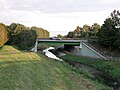
 The Seseke near Bönen. Technical expansion in the subsidence area . In the background the former Königsborn III / IV colliery . |
||
| Data | ||
| Water code | DE : 27876 | |
| location | North Rhine-Westphalia , Germany | |
| River system | Rhine | |
| Drain over | Lippe → Rhine → North Sea | |
| source | At Holtum (Werl) 51 ° 33 ′ 0 ″ N , 7 ° 50 ′ 55 ″ E |
|
| Source height | approx. 94 m above sea level NN | |
| muzzle | In Lünen coordinates: 51 ° 36 ′ 39 ″ N , 7 ° 31 ′ 45 ″ E 51 ° 36 ′ 39 ″ N , 7 ° 31 ′ 45 ″ E |
|
| Mouth height | approx. 48 m above sea level NN | |
| Height difference | approx. 46 m | |
| Bottom slope | approx. 1.4 ‰ | |
| length | 31.9 km | |
| Catchment area | 319.279 km² | |
The Seseke (formerly also called Sisecke, Sesike or Zesik) is a left-hand tributary of the Lippe in North Rhine-Westphalia . It does not have an excellent spring , but is fed from several streams and ditches in the Werl-Holtum and Unna-Hemmerde area. As part of the Seseke program, the formerly open wastewater course was transformed from 1984 by the Lippeverband into a sewage-free and natural river landscape. The catchment area of the Seseke covers an area of 319.45 km². The largest tributary of the Seseke is the Körnebach , the longest the Lünerner Bach with 13.5 km.
The Roman historian Cassius Dio names a river called "Elison" in connection with the Drusus campaigns (12 to 8 BC). It should be the Seseke. The original meaning of the name "Seseke" is unclear and difficult to interpret; possibly it is the contraction of a reconstructed Old Saxon personal name Sīsilo with the basic word beke ("Bach").
Water development - The Seseke program
For decades, the lower reaches of the Seseke from Bönen served as an open wastewater course to discharge the region's wastewater under subsidence conditions . With the step-by-step implementation of the Seseke program, the Lippeverband, as the leading river manager in the Lippe region, has started to remodel the Seseke area in a natural way. For this purpose, underground channels first had to be laid along all the streams that had been converted into open wastewater courses - the longest and most complex part of the Seseke program. Between the late 1980s and 2012, the Lippeverband built four sewage treatment plants and around 75 closed sewers. Since then, only purified water has flowed in the Seseke and its tributaries. The wastewater is conducted in underground canals running parallel to the water to the sewage treatment plants in Bönen, Kamen , Dortmund-Scharnhorst and Lünen , where it is cleaned and discharged into the Seseke or its tributaries Rexebach and Körnebach .
It was only after the sewage was cleared that the upper reaches of the Seseke and its tributaries could be improved ecologically and transformed into a natural river landscape. In parallel to the construction of the new wastewater infrastructure, the Lippeverband has ecologically improved a total of 73 km of watercourses in the Seseke catchment area. The Seseke itself was transformed from a straight, concrete slab of water into a natural, curved river course. For this purpose, the concrete shells were removed from the river bed, the embankments flattened and shallow water zones and rain retention areas created. In many areas, the flora and fauna were stimulated through initial planting and the use of burbot , so that nature can then continue to develop naturally. In the course of development, a typical flood plain with individual large trees ( hornbeam , field maple , bird cherry and ash ) will emerge. At the upper edge of the slope , bushes (e.g. hawthorn , eucoat and snowball ) were planted. The Lippeverband has also laid out a footpath and bicycle path from Bönen to Lünen, which invites you to discover the new landscape and recreational area.
The renovation of the Seseke was artistically accompanied in the Ruhr.2010 Capital of Culture year by the project Walking over water in order to bring the river closer to public awareness.
Communities on the Seseke

The Sesekebrücke in Kamen is one of the oldest railway bridges in Germany.
Tributaries
In the following, the tributaries of the Seseke are listed in the order from the source to the mouth. The respective length, the mouth height and, if available, the size of the catchment area are mentioned.
- Schillingsbach - 3.1 km long, left tributary at 89 m above sea level. NN
- Strangbach - 2.8 km long, right tributary at 75 m above sea level. NN
- Seelhofsbach - 1.8 km long, right tributary at 74 m above sea level. NN
- Lünerner Bach - 13.5 km long, left tributary at 67 m above sea level. NN (catchment area: 43.92 km²)
- Sandbach - 3.1 km long, right tributary at 66 m above sea level. NN
- Kleingarnsbach - 4.2 km long, left tributary at 65 m above sea level. NN
- Kleine Seseke - 0.9 km long, left tributary at 63 m above sea level. NN
- Rexebach - 1.8 km long, right tributary at 63 m above sea level. NN
- Heerener Mühlbach - 6.6 km long, left tributary at 62 m above sea level. NN (catchment area: 27,157 km²)
- Kohlbach - 4.0 km long, right tributary at 60 m above sea level. NN
- Derner Bach - 4.4 km long, right tributary at 60 m above sea level. NN
- Körnebach - 12.9 km long, left tributary at 60 m above sea level. NN (catchment area: 113.626 km²)
- Braunebach - 3.8 km long, left tributary at 57 m above sea level. NN
- Spulbach - 2.1 km long, right tributary at 55 m above sea level. NN
- Lüner Grenzgraben - 1.8 km long, left tributary at 55 m above sea level. NN
- Mohnbach - 2.7 km long, left tributary at 55 m above sea level. NN
- Alkenbach - 1.8 km long, right tributary at 53 m above sea level. NN
- Kuhbach - 8.7 km long, right tributary at 53 m above sea level. NN (catchment area: 15.874 km²)
- Lüserbach - 4.8 km long, left tributary at 51 m above sea level. NN
- Süggelbach - 7.9 km long, left tributary at 51 m above sea level. NN (catchment area: 18.05 km²)
Picture gallery

The Seseke in Kamen

The diked Seseke just before the Datteln-Hamm Canal

Reconstruction work back to the near-natural river
Bridge of the A 2; on the right the Seseke cycle path

Art project 2011 Walking over water , Christian Hasucha , NOW at the mouth of the Braunebach

The Seseke flows into the Lippe


Individual evidence
- ↑ a b c Topographic map 1: 25,000
- ↑ a b c d Topographical Information Management, Cologne District Government, Department GEObasis NRW ( information )
- ^ Cassius Dio: Historia Romana 54, 33, 4.
- ↑ Reinhard Wolters: The battle in the Teutoburg Forest. Arminius, Varus and Roman Germania. 2nd revised edition. Munich 2009, p. 44, note 22.
- ↑ See Albrecht Greule (with the collaboration of Sabine Hackl-Rößler): Deutsches Gewässernamenbuch. Etymology of the water body names and the associated area, settlement and field names. Berlin / Boston 2014, ISBN 978-3-11-019039-7 , here: p. 496, entry "Seseke".
- ^ Britta Linnhoff: After renaturation: again fish in the Seseke. WAZ, November 6, 2015
- ↑ a b Mühlbach.kurier, No. 3/2014, p. 1.
- ↑ Information on the establishment of the Seseke cooperative ( Memento of the original from January 26, 2016 in the Internet Archive ) Info: The archive link was automatically inserted and has not yet been checked. Please check the original and archive link according to the instructions and then remove this notice.
- ↑ Information on the art project Walking over water ( Memento of the original from September 15, 2010 in the Internet Archive ) Info: The archive link was automatically inserted and not yet checked. Please check the original and archive link according to the instructions and then remove this notice.
- ^ Emschergenossenschaft / Lippeverband: Redesign of the Seseke - a new face for a river.