
Alt-Scharnhorst
|
Alt-Scharnhorst
City of Dortmund
|
|
|---|---|
 |
|
| Height : | 71 m above sea level NHN |
| Area : | 4.23 km² |
| Residents : | 8817 (Dec. 31, 2019) |
| Population density : | 2,084 inhabitants / km² |
| Postal code : | 44328 |
| Area code : | 0231 |
| Statistical District : | 66 |
  Location of Alt-Scharnhorst in Dortmund
|
|
Alt-Scharnhorst is a district in the north-east of Dortmund at an altitude of 71 m above sea level. NHN with 8,817 inhabitants. The district is often referred to as Scharnhorst in connection with the large Scharnhorst-Ost housing estate. Today Alt-Scharnhorst is a very diverse district. There are both high-quality single house developments (mainly on the southern or south-eastern outskirts), middle-class row house settlements, and settlements with considerable social difficulties.
Scharnhorst is one of the 13 socially disadvantaged districts.
Initially, this statistical sub-district was called Scharnhorst-Alt .
Emergence
The history of today's Dortmund district of Alt-Scharnhorst is closely linked to mining. After the Scharnhorst colliery, named after General Scharnhorst , was built in what was then a rural area from 1871, several colliery settlements were built in the area to accommodate the miners. The population grew from about 100 people in 1890 to 5678 people in 1939. A separate district called Scharnhorst was created in 1918 when Brackel and Wambel were incorporated into Dortmund and included the parts of these communities north of the Dortmund – Hamm railway line.
In the years after the Second World War, the MSA settlement was built with funds from the Marshall Plan . From 1954, the first of a total of 800 own homes and 521 rental apartments were occupied; Ultimately, the population rose to over 11,000 people.
Due to the great housing shortage, a new large housing estate was built on the site east of Flughafenstrasse from 1965, which is known as Scharnhorst-Ost (Neu-Scharnhorst).
population
Structure of the Alt-Scharnhorst population:
- Share of the population under 18-year-olds: 16.1% [Dortmund average: 16.2% (2018)]
- Population share of at least 65-year-olds: 21.9% [Dortmund average: 20.2% (2018)]
- Proportion of foreigners: 13.4% [Dortmund average: 18.8% (2019)]
- Unemployment rate: 9.2% [Dortmund average: 11.0% (2017)]
The average income in Alt-Scharnhorst is around 20% below the Dortmund average.
Population development
| year | 1987 | 2003 | 2008 | 2010 | 2013 | 2016 | 2017 | 2019 |
|---|---|---|---|---|---|---|---|---|
| Residents | 8955 | 8474 | 8329 | 8261 | 8276 | 8517 | 8592 | 8817 |
traffic
Alt-Scharnhorst is bounded to the south and west by the Dortmund – Enschede railway (Westmünsterland-Bahn) and the Dortmund – Hamm railway . With the DB Dortmund-Kirchderne and Dortmund-Scharnhorst stops and the Gleiwitzstraße tram stop , Alt-Scharnhorst is well connected to the local public transport network. Furthermore, with the connection between Dortmund-Scharnhorst and Bundesstraße 236 n and Brackeler Straße, there is an excellent connection to the city center, to Bundesautobahn 1 , Bundesautobahn 2 and the nearby Bundesstraße 1 .
| line | course | Tact |
|---|---|---|
| U 42 |
DO-Grevel - Droote - Scharnhorst center - Flughafenstrasse - Gleiwitzstrasse - Kirchderne - Franz-Zimmer-Siedlung - Schulte Rödding - Bauernkamp - An den Teichen - Burgholz - Eisenstrasse - Glückaufstrasse - U Brunnenstrasse - U Brügmannplatz - U Reinoldikirche This line runs on the trunk line II |
10 min |
Personalities
The journalist and resistance fighter Kurt Julius Goldstein was born in Scharnhorst and spent part of his childhood there.
Others
In Alt-Scharnhorst there are three churches, the Catholic St. Immaculata Church, the Protestant Church of the Resurrection and the New Apostolic Church Scharnhorst.
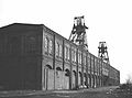
The Scharnhorst colliery in the 1970s
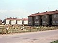
The MSA settlement Dortmund-Scharnhorst in the 1950s
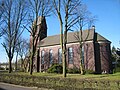
The Church of the Resurrection

_50er.jpg)

Web links
Individual evidence
- ↑ Population figures in the statistical districts on December 31, 2019 (PDF)
- ↑ Population share of the under 18 year olds Statistical Atlas 2019 (PDF file)
- ↑ Population share of at least 65-year-olds Statistical Atlas 2019 (PDF file)
- ↑ Nationalities in the statistical districts on December 31, 2019 (PDF file)
- ↑ Unemployment rates by statistical district on June 30, 2017 (PDF file)

Aplerbeck :
Aplerbeck (with Aplerbecker Mark ) |
Berghofen (with Berghofer Mark ) |
Stoke |
Sölde |
Sölderholz (with Lichtendorf )
Brackel :
woodlice |
Brackel (with Neuasseln ) |
Wobble |
Wickede
Eving :
Brechte |
Eving (with Kemminghausen ) |
Holthausen |
Lindenhorst
Hombruch :
Barop (with Schönau ) |
Bitter pulp |
Brünninghausen (with Renninghausen ) |
Eichlinghofen (with spreaders ) |
Hombruch |
Kirchhörde-Löttringhausen (with Großholthausen , Kirchhörde , Kleinholthausen , Löttringhausen and Schanze ) |
Menglinghausen |
Persebeck-Kruckel-Schnee (with Kruckel , Persebeck and Schnee ) |
Rombergpark-Lücklemberg (with Lücklemberg )
Hörde :
Benninghofen (with Loh ) |
Hacheney |
Wood (with highest ) |
Hörde (with Clarenberg ) |
Syburg (with Buchholz ) |
Wellinghofen (with Niederhofen ) |
Wichlinghofen
Huckarde :
Deusen |
Huckarde (with whiskers ) |
Jungferntal cream (with Jungferntal and cream ) |
Kirchlinde (with Hangeney )
city center north :
Borsigplatz |
Port |
Nordmarkt
Innenstadt-Ost :
Kaiserbrunnen (with grains ) |
Ruhrallee |
Westfalendamm (with Gartenstadt ) City Center
West :
City |
Dorstfeld |
Dorstfeld Bridge |
Westfalenhalle (with Kreuzviertel )
Lütgendortmund :
Bövinghausen |
Kley |
Lütgendortmund (with Holte-Kreta and Somborn ) |
Marten |
Oespel |
Westrich (with Dellwig )
Mengede :
Bodelschwingh |
Mengede (with Brüninghausen ) |
Nice |
Oestrich |
Schwieringhausen (with Ellinghausen and Groppenbruch ) |
Westerfilde
Scharnhorst :
Alt-Scharnhorst |
Derne |
Hostedde (with Grevel ) |
Kirchderne |
Kurl-Husen (with Fleier , Husen and Kurl ) |
Lanstrop |
Scharnhorst-Ost