
Bitter pulp
|
Bitter pulp
City of Dortmund
Coordinates: 51 ° 26 ′ 48 ″ N , 7 ° 27 ′ 52 ″ E
|
|
|---|---|
| Height : | 199 m above sea level NHN |
| Area : | 3.63 km² |
| Residents : | 2692 (Dec. 31, 2019) |
| Population density : | 743 inhabitants / km² |
| Incorporation : | August 1, 1929 |
| Postcodes : | 44227, 44229 |
| Area code : | 0231 |
| Statistical District : | 62 |
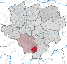  Location of Bittermark in Dortmund
|
|

Bittermark is the statistical district 62 and at the same time a southern part of the city of Dortmund . It is located in the district of Hombruch , has an area of 363 hectares and has around 2700 inhabitants. The residential development of the Bittermark is primarily characterized by single-family houses and a low settlement density. The forest near Bittermark is considered an upscale residential area with corresponding real estate and land prices. The federal motorway 45 runs through the district .
history
For centuries, the Bittermark was a pure forest area on the northern slopes of the Ardey Mountains . The first settlement began after 1770 through clearing and the construction of isolated cottages . The Bittermark area was administered by the parish of Kirchhörde .
Part of the Wellinghofen office in the Hörde district , the Bittermark fell in 1925 as part of the incorporation into the city of Dortmund.
Industrialization moved into Bittermark with the opening of the Gottessegen mine . Today the colliery is reminiscent of a workshop for the disabled with the same name and the colliery's former extinguishing water ponds .
Towards the end of the Second World War, crimes at the end of the war were committed in the city forest of Bittermark . At Easter 1945, from March 7th to April 12th, around 300 people were murdered by the Gestapo in a clearing in the Bittermark, in Rombergpark and on the railway site between Hörde and Berghofen . The Bittermark memorial has been a reminder of the crimes since 1960 . Every year on Good Friday there is a memorial service in honor of the victims.
population
On December 31, 2019, there were 2,692 residents in Bittermark.
Structure of the bitter marker population:
- Share of the population under 18-year-olds: 13.3% [Dortmund average: 16.2% (2018)]
- Population share of at least 65-year-olds: 25.4% [Dortmund average: 20.2% (2018)]
- Proportion of foreigners: 5.2% [Dortmund average: 18.8% (2019)]
- Unemployment rate: 4.1% [Dortmund average: 11.0% (2017)]
The average income in Bittermark is around 85% above the Dortmund average.
Population development
| year | Pop. |
|---|---|
| 1987 | 2297 |
| 2003 | 2518 |
| 2008 | 2563 |
| 2010 | 2581 |
| 2013 | 2639 |
| 2016 | 2711 |
| 2018 | 2706 |
Web links
Individual evidence
- ↑ Population figures in the statistical districts on December 31, 2019 (PDF)
- ↑ Jan Niko Kirschbaum: memorials as signs of time. National Socialism in the culture of remembrance in North Rhine-Westphalia . transcript, Bielefeld 2020, ISBN 978-3-8376-5064-8 , pp. 156-184.
- ↑ Population share of the under 18 year olds Statistical Atlas 2019 (PDF file)
- ↑ Population share of at least 65-year-olds Statistical Atlas 2019 (PDF file)
- ↑ Nationalities in the statistical districts on December 31, 2019 (PDF file)
- ↑ Unemployment rates according to statistical districts on June 30, 2017 ( memento of the original from June 25, 2018 in the Internet Archive ) Info: The archive link was inserted automatically and has not yet been checked. Please check the original and archive link according to the instructions and then remove this notice. (PDF file)

Aplerbeck :
Aplerbeck (with Aplerbecker Mark ) |
Berghofen (with Berghofer Mark ) |
Stoke |
Sölde |
Sölderholz (with Lichtendorf )
Brackel :
woodlice |
Brackel (with Neuasseln ) |
Wobble |
Wickede
Eving :
Brechte |
Eving (with Kemminghausen ) |
Holthausen |
Lindenhorst
Hombruch :
Barop (with Schönau ) |
Bitter pulp |
Brünninghausen (with Renninghausen ) |
Eichlinghofen (with spreaders ) |
Hombruch |
Kirchhörde-Löttringhausen (with Großholthausen , Kirchhörde , Kleinholthausen , Löttringhausen and Schanze ) |
Menglinghausen |
Persebeck-Kruckel-Schnee (with Kruckel , Persebeck and Schnee ) |
Rombergpark-Lücklemberg (with Lücklemberg )
Hörde :
Benninghofen (with Loh ) |
Hacheney |
Wood (with highest ) |
Hörde (with Clarenberg ) |
Syburg (with Buchholz ) |
Wellinghofen (with Niederhofen ) |
Wichlinghofen
Huckarde :
Deusen |
Huckarde (with whiskers ) |
Jungferntal cream (with Jungferntal and cream ) |
Kirchlinde (with Hangeney )
city center north :
Borsigplatz |
Port |
Nordmarkt
Innenstadt-Ost :
Kaiserbrunnen (with grains ) |
Ruhrallee |
Westfalendamm (with Gartenstadt ) City Center
West :
City |
Dorstfeld |
Dorstfeld Bridge |
Westfalenhalle (with Kreuzviertel )
Lütgendortmund :
Bövinghausen |
Kley |
Lütgendortmund (with Holte-Kreta and Somborn ) |
Marten |
Oespel |
Westrich (with Dellwig )
Mengede :
Bodelschwingh |
Mengede (with Brüninghausen ) |
Nice |
Oestrich |
Schwieringhausen (with Ellinghausen and Groppenbruch ) |
Westerfilde
Scharnhorst :
Alt-Scharnhorst |
Derne |
Hostedde (with Grevel ) |
Kirchderne |
Kurl-Husen (with Fleier , Husen and Kurl ) |
Lanstrop |
Scharnhorst-Ost