
Difficultinghausen
|
Difficultinghausen
City of Dortmund
Coordinates: 51 ° 34 ′ 57 ″ N , 7 ° 25 ′ 29 ″ E
|
|
|---|---|
| Height : | 77 m above sea level NHN |
| Area : | 10.23 km² |
| Residents : | 776 (Dec. 31, 2019) |
| Population density : | 76 inhabitants / km² |
| Incorporation : | October 27, 1917 |
| Incorporated into: | Amount of money |
| Postal code : | 44359 |
| Area code : | 0231 |
| Statistical District : | 95 |
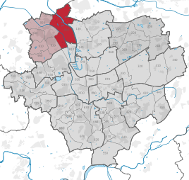  Location of Schwieringhausen in Dortmund
|
|


Schwieringhausen is a district in the north of Dortmund and belongs to the Mengede district .
The district, which is also called Swirinckhuß or Schwinghausen in older maps, probably got its name from Heinrich von Schwederinghausen, who was mentioned in a document in 1398. Since the 16th century the place belonged to the former county of Dortmund . Schwieringhausen borders in the west on the Emscher river and in the east on the Bundesautobahn 2 .
The district gained temporary importance through the brittle brickworks founded in 1903 and now disused and brittle, which was at times the largest in North Rhine-Westphalia, as well as the coal port of the Minister Achenbach mine in Brambauer, which was closed in 1992 . There is still a small polystyrene production facility on the brick premises , which is run by the fourth generation of the founding family.
On October 27, 1917 Schwieringhausen was incorporated into Mengede and finally incorporated into the city of Dortmund on April 1, 1928 together with Mengede.
Parts of the place were given to the city of Lünen in exchange on July 1, 1950 . This is the area to the west of Schulenkampstraße, Sister-Elisabeth-Weg, Pfarrer-Kock-Weg and the branch of Ferdinandstraße leading to Waltroper Kanonenstraße in the Brambauer district of Lüner (together about 82.28 hectares).
Some parts of the village to the west of the Dortmund-Ems Canal are designated as a nature reserve. Heck cattle were released there in 2003, contributing to the natural maintenance of the landscape.
statistics
Structure of the Schwieringhauser population:
- Share of the population under 18-year-olds: 14.2% [Dortmund average: 16.2% (2018)]
- Population share of at least 65-year-olds: 15.3% [Dortmund average: 20.2% (2018)]
- Proportion of foreigners: 6.2% [Dortmund average: 18.8% (2019)]
- Unemployment rate: 4.0% [Dortmund average: 11.0% (2017)]
The average income in Schwieringhausen is around 5% below the Dortmund average.
Population development
| year | 1987 | 2003 | 2008 | 2013 | 2016 | 2018 |
|---|---|---|---|---|---|---|
| Residents | 707 | 786 | 816 | 830 | 805 | 804 |
geography
The place is at an altitude of 77 m above sea level. NHN .
Individual evidence
- ↑ Population figures in the statistical districts on December 31, 2019 (PDF)
- ↑ a b Stephanie Reekers: The regional development of the districts and communities of Westphalia 1817-1967 . Aschendorff, Münster Westfalen 1977, ISBN 3-402-05875-8 , p. 227, 262, 281 .
- ↑ Population share of the under 18 year olds Statistical Atlas 2019 (PDF file)
- ↑ Population share of at least 65-year-olds Statistical Atlas 2019 (PDF file)
- ↑ Nationalities in the statistical districts on December 31, 2019 (PDF file)
- ↑ Unemployment rates by statistical district on June 30, 2017 (PDF file)

Aplerbeck :
Aplerbeck (with Aplerbecker Mark ) |
Berghofen (with Berghofer Mark ) |
Stoke |
Sölde |
Sölderholz (with Lichtendorf )
Brackel :
woodlice |
Brackel (with Neuasseln ) |
Wobble |
Wickede
Eving :
Brechte |
Eving (with Kemminghausen ) |
Holthausen |
Lindenhorst
Hombruch :
Barop (with Schönau ) |
Bitter pulp |
Brünninghausen (with Renninghausen ) |
Eichlinghofen (with spreaders ) |
Hombruch |
Kirchhörde-Löttringhausen (with Großholthausen , Kirchhörde , Kleinholthausen , Löttringhausen and Schanze ) |
Menglinghausen |
Persebeck-Kruckel-Schnee (with Kruckel , Persebeck and Schnee ) |
Rombergpark-Lücklemberg (with Lücklemberg )
Hörde :
Benninghofen (with Loh ) |
Hacheney |
Wood (with highest ) |
Hörde (with Clarenberg ) |
Syburg (with Buchholz ) |
Wellinghofen (with Niederhofen ) |
Wichlinghofen
Huckarde :
Deusen |
Huckarde (with whiskers ) |
Jungferntal cream (with Jungferntal and cream ) |
Kirchlinde (with Hangeney )
city center north :
Borsigplatz |
Port |
Nordmarkt
Innenstadt-Ost :
Kaiserbrunnen (with grains ) |
Ruhrallee |
Westfalendamm (with Gartenstadt ) City Center
West :
City |
Dorstfeld |
Dorstfeld Bridge |
Westfalenhalle (with Kreuzviertel )
Lütgendortmund :
Bövinghausen |
Kley |
Lütgendortmund (with Holte-Kreta and Somborn ) |
Marten |
Oespel |
Westrich (with Dellwig )
Mengede :
Bodelschwingh |
Mengede (with Brüninghausen ) |
Nice |
Oestrich |
Schwieringhausen (with Ellinghausen and Groppenbruch ) |
Westerfilde
Scharnhorst :
Alt-Scharnhorst |
Derne |
Hostedde (with Grevel ) |
Kirchderne |
Kurl-Husen (with Fleier , Husen and Kurl ) |
Lanstrop |
Scharnhorst-Ost