Persebeck-Kruckel-Snow
|
Persebeck-Kruckel-Snow
City of Dortmund
Coordinates: 51 ° 26 ′ 50 ″ N , 7 ° 25 ′ 0 ″ E
|
|
|---|---|
| Height : | approx. 160 m above sea level NHN |
| Area : | 5.19 km² |
| Residents : | 4009 (December 31, 2018) |
| Population density : | 772 inhabitants / km² |
| Postal code : | 44227 |
| Area code : | 0231 |
| Statistical District : | 66 |
|
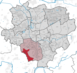
Location of Persebeck-Kruckel-Schnee in Dortmund
|
|
Persebeck-Kruckel-Schnee is the statistical district 66 of the urban city of Dortmund . It is located in the southwest of the city and belongs to the Hombruch district .
The statistical district consists of the districts of Kruckel , Persebeck and Schnee . The community of Persebeck was incorporated into Barop in 1920 . The districts of Kruckel and Schnee belonged to Kirchhörde .
The communities Barop and Kirchhörde belonged to the district of Dortmund . On April 1, 1887, they were reclassified to the newly formed Hörde district . On August 1, 1929, this circle was dissolved. Barop and Kirchhörde were incorporated into the city of Dortmund.
Initially, this statistical sub-district was called Hombruch-Südwest .
statistics
As of December 31, 2018, 4,009 inhabitants lived in the statistical district of Persebeck-Kruckel-Schnee.
Structure of the population:
- Minor quota: 21.8% [Dortmund average: 19.4% (2016)]
- Old age quota: 34.4% [Dortmund average: 30.0% (2016)]
- Proportion of foreigners: 4.1% [Dortmund average: 18.2% (2018)]
- Unemployment rate: 4.2% [Dortmund average: 11.0% (2017)]
The average income is around 25% above the Dortmund average.
Population development
| year | Pop. |
|---|---|
| 1987 | 3789 |
| 2003 | 3855 |
| 2008 | 3981 |
| 2013 | 4000 |
| 2016 | 4031 |
| 2018 | 4009 |
Structure of the statistical district 66
| Subdistrict | Surname | area |
|---|---|---|
| 661 | Persebeck | District Persebeck with border shifts to Salingen and Menglinghausen; small part in the west of the Kirchhörde district, northwest of the railway (which is today's border with Kruckel) |
| 662 | Kruckel | Extreme west of the Kirchhörde district |
| 663 | snow | Sparsely populated southwest of the Kirchhörde district |
Individual evidence
- ↑ Population figures in the statistical districts on December 31, 2018 (PDF)
- ↑ Stephanie Reekers: The regional development of the districts and communities of Westphalia 1817-1967 . Aschendorff, Münster Westfalen 1977, ISBN 3-402-05875-8 , p. 273 .
- ↑ Stephanie Reekers: The regional development of the districts and communities of Westphalia 1817-1967 . Aschendorff, Münster Westfalen 1977, ISBN 3-402-05875-8 , p. 212 and 253 .
- ↑ Population structures annual report 2016 (PDF file)
- ↑ Population structures annual report 2016 (PDF file)
- ↑ Nationalities in the statistical districts as of December 31, 2018 (PDF file)
- ↑ Unemployment rates by statistical district on June 30, 2017 (PDF file)


