
Westerfilde
|
Westerfilde
City of Dortmund
Coordinates: 51 ° 33 ′ 0 ″ N , 7 ° 23 ′ 0 ″ E
|
|
|---|---|
| Height : | 81 m above sea level NHN |
| Area : | 3.05 km² |
| Residents : | 6884 (Dec. 31, 2019) |
| Population density : | 2.259 inhabitants / km² |
| Incorporation : | April 1, 1928 |
| Postal code : | 44357 |
| Area code : | 0231 |
| Statistical District : | 96 |
  Location of Westerfilde in Dortmund
|
|
Westerfilde is the statistical district 96 and at the same time a district in the north-west of the urban city of Dortmund . It belongs to the Mengede district .
geography
Westerfilde is located about 7 kilometers northwest of Dortmund city center. Geographically, with the exception of the northern transition to Bodelschwingh, the residential development in Westerfild is clearly demarcated from its neighboring districts. To the west of the settlement area runs the federal motorway 45 , which here is part of the Dortmund motorway ring.
The place is characterized in large parts by larger multi-family and high-rise estates. In the southern area of Westerfildes and on the western outskirts, however, there are predominantly single and two-family houses.
history
The present-day Dortmund district of Westerfilde already existed, as a document shows, in the late 13th century, presumably as a small farming community. Until the beginning of the industrial age, which began in Westerfilde with the sinking of the Westhausen colliery in 1873 , the nearby castles House Westhusen and House Bodelschwingh are worth mentioning.
On April 1, 1928, Westerfilde was incorporated into Dortmund.
The buildings of the Westhausen colliery that are still preserved today are among the most architecturally significant in the entire Ruhr area and are an important part of the route of industrial culture .
Today, due to high unemployment and a relatively low average income, Westerfilde is one of the 13 socially disadvantaged districts of Dortmund. In particular, the "large housing estate Speckestrasse" that was built in the 1970s was considered a social hotspot for a long time. But meanwhile the new owners are beginning to counteract the renovation backlog of the estate with extensive modernizations.
population
Structure of the population in Westerfild:
- Share of the population under 18-year-olds: 20.6% [Dortmund average: 16.2% (2018)]
- Population share of at least 65-year-olds: 18.6% [Dortmund average: 20.2% (2018)]
- Proportion of foreigners: 26.7% [Dortmund average: 18.8% (2019)]
- Unemployment rate: 16.5% [Dortmund average: 11.0% (2017)]
The average income in Westerfilde is around 15% below the Dortmund average.
Population development
| year | 1987 | 2003 | 2008 | 2013 | 2016 | 2018 |
|---|---|---|---|---|---|---|
| Residents | 7540 | 7151 | 6397 | 6775 | 7073 | 6901 |
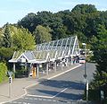
Tram terminus
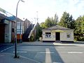
S-Bahn stop


The well-known Tante Amanda beer garden is located to the west of Autobahn 45 in the district .
The sports club Germania Westerfilde-Bodelschwingh is a sporting part of the history of Westerfilde . The football department plays in the district league A in Dortmund.
Web links
- Westerfilde in the Westphalia Culture Atlas
Individual evidence
- ↑ Population figures in the statistical districts on December 31, 2019 (PDF)
- ↑ Stephanie Reekers: The regional development of the districts and communities of Westphalia 1817-1967 . Aschendorff, Münster Westfalen 1977, ISBN 3-402-05875-8 , p. 294 .
- ↑ Population share of the under 18 year olds Statistical Atlas 2019 (PDF file)
- ↑ Population share of at least 65-year-olds Statistical Atlas 2019 (PDF file)
- ↑ Nationalities in the statistical districts on December 31, 2019 (PDF file)
- ↑ Unemployment rates by statistical district on June 30, 2017 (PDF file)

Aplerbeck :
Aplerbeck (with Aplerbecker Mark ) |
Berghofen (with Berghofer Mark ) |
Stoke |
Sölde |
Sölderholz (with Lichtendorf )
Brackel :
woodlice |
Brackel (with Neuasseln ) |
Wobble |
Wickede
Eving :
Brechte |
Eving (with Kemminghausen ) |
Holthausen |
Lindenhorst
Hombruch :
Barop (with Schönau ) |
Bitter pulp |
Brünninghausen (with Renninghausen ) |
Eichlinghofen (with spreaders ) |
Hombruch |
Kirchhörde-Löttringhausen (with Großholthausen , Kirchhörde , Kleinholthausen , Löttringhausen and Schanze ) |
Menglinghausen |
Persebeck-Kruckel-Schnee (with Kruckel , Persebeck and Schnee ) |
Rombergpark-Lücklemberg (with Lücklemberg )
Hörde :
Benninghofen (with Loh ) |
Hacheney |
Wood (with highest ) |
Hörde (with Clarenberg ) |
Syburg (with Buchholz ) |
Wellinghofen (with Niederhofen ) |
Wichlinghofen
Huckarde :
Deusen |
Huckarde (with whiskers ) |
Jungferntal cream (with Jungferntal and cream ) |
Kirchlinde (with Hangeney )
city center north :
Borsigplatz |
Port |
Nordmarkt
Innenstadt-Ost :
Kaiserbrunnen (with grains ) |
Ruhrallee |
Westfalendamm (with Gartenstadt ) City Center
West :
City |
Dorstfeld |
Dorstfeld Bridge |
Westfalenhalle (with Kreuzviertel )
Lütgendortmund :
Bövinghausen |
Kley |
Lütgendortmund (with Holte-Kreta and Somborn ) |
Marten |
Oespel |
Westrich (with Dellwig )
Mengede :
Bodelschwingh |
Mengede (with Brüninghausen ) |
Nice |
Oestrich |
Schwieringhausen (with Ellinghausen and Groppenbruch ) |
Westerfilde
Scharnhorst :
Alt-Scharnhorst |
Derne |
Hostedde (with Grevel ) |
Kirchderne |
Kurl-Husen (with Fleier , Husen and Kurl ) |
Lanstrop |
Scharnhorst-Ost