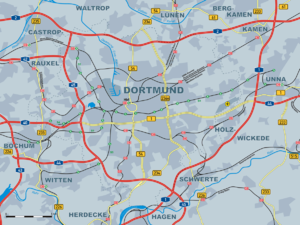
Dortmund motorway ring
| Dortmund Ring | ||||||||||||||||||||||||||||||||||||||||||||||||||||||||||||||||||||||||||||||||||||||||||||||||||||||||||||||||||||||||||||||||||||||||||||||||||||||||||
|---|---|---|---|---|---|---|---|---|---|---|---|---|---|---|---|---|---|---|---|---|---|---|---|---|---|---|---|---|---|---|---|---|---|---|---|---|---|---|---|---|---|---|---|---|---|---|---|---|---|---|---|---|---|---|---|---|---|---|---|---|---|---|---|---|---|---|---|---|---|---|---|---|---|---|---|---|---|---|---|---|---|---|---|---|---|---|---|---|---|---|---|---|---|---|---|---|---|---|---|---|---|---|---|---|---|---|---|---|---|---|---|---|---|---|---|---|---|---|---|---|---|---|---|---|---|---|---|---|---|---|---|---|---|---|---|---|---|---|---|---|---|---|---|---|---|---|---|---|---|---|---|---|---|---|
|
|
||||||||||||||||||||||||||||||||||||||||||||||||||||||||||||||||||||||||||||||||||||||||||||||||||||||||||||||||||||||||||||||||||||||||||||||||||||||||||
| map | ||||||||||||||||||||||||||||||||||||||||||||||||||||||||||||||||||||||||||||||||||||||||||||||||||||||||||||||||||||||||||||||||||||||||||||||||||||||||||
| Basic data | ||||||||||||||||||||||||||||||||||||||||||||||||||||||||||||||||||||||||||||||||||||||||||||||||||||||||||||||||||||||||||||||||||||||||||||||||||||||||||
| Operator: |
|
|||||||||||||||||||||||||||||||||||||||||||||||||||||||||||||||||||||||||||||||||||||||||||||||||||||||||||||||||||||||||||||||||||||||||||||||||||||||||
| Overall length: | 72.4 km | |||||||||||||||||||||||||||||||||||||||||||||||||||||||||||||||||||||||||||||||||||||||||||||||||||||||||||||||||||||||||||||||||||||||||||||||||||||||||
|
State : |
||||||||||||||||||||||||||||||||||||||||||||||||||||||||||||||||||||||||||||||||||||||||||||||||||||||||||||||||||||||||||||||||||||||||||||||||||||||||||
|
Course of the road
|
||||||||||||||||||||||||||||||||||||||||||||||||||||||||||||||||||||||||||||||||||||||||||||||||||||||||||||||||||||||||||||||||||||||||||||||||||||||||||
In a clockwise direction, the Dortmund motorway ring consists of a large part of the city of Dortmund and parts of the cities of Kamen , Unna , Holzwickede and Schwerte, ring-shaped motorway sections of the A 2 , the A 1 and the A 45 between the Dortmund-Nordwest intersection and the Kamener Cross and the Westhofen Cross with a length of 72.4 km. The ring is the central transition point between these three highly frequented motorways and therefore has to cope with the local traffic flows at the same time as the long-distance traffic. It is therefore one of the most heavily loaded and congestion-prone motorway sections in Germany .
The Dortmunder Ring crosses the A 44 at the Dortmund / Unna junction , the A 40 at the Dortmund-West junction , the A 42 at the Castrop-Rauxel-Ost junction and the A 44 at the Dortmund / Witten junction .
Current condition
The traffic load on the Dortmund motorway ring has increased continuously since the 1970s. Structurally planned extensions to six lanes were implemented almost everywhere. The Kamener Kreuz was fundamentally rebuilt by 2009. The previous cloverleaf shape was broken up.
