
Huckarde district
|
Huckarde district
City of Dortmund
Coordinates: 51 ° 32 ′ 0 ″ N , 7 ° 24 ′ 0 ″ E
|
|
|---|---|
| Height : | 75 m above sea level NN |
| Area : | 15.1 km² |
| Residents : | 36,508 (Dec. 31, 2018) |
| Population density : | 2,418 inhabitants / km² |
| Postcodes : | 44359, 44369, 44379, 44147, 44388 |
| Area code : | 0231 |
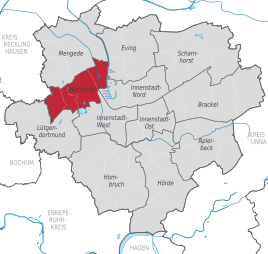  Location of the Dortmund district of Huckarde within Dortmund.
|
|


Huckarde is a district and at the same time a district in the west of Dortmund .
The first settlements in Huckarde, near today's Oberfeldstrasse, could be proven up to the time around the birth of Christ. In a document from Essen Abbey it is mentioned that around 860 Hukretha passed into the possession of Altfrid , Bishop of Hildesheim and founder of the Abbey. During the construction of a well in 1810, hard coal was found for the first time in what was until then a purely agricultural district . When the Hansa colliery, which was closed in 1980, was founded in 1855, the industrial age also began in Huckarde. In 1914, Huckarde was incorporated into the city of Dortmund .
The district has been connected to the Emschertal Railway since 1892 . In 1908 Huckarde received a representative passenger station .
Today (2018) with 36,508 inhabitants on 1500 hectares, Huckarde is one of the smallest urban districts in Dortmund. Despite the sometimes high population density of 23.9 inhabitants / ha, Huckarde today offers sufficient areas for local recreation with the Rahmer Forest, the Revierpark Wischlingen leisure center and the Deusenberg in the neighboring district of Deusen . The disused Hansa coking plant could also be of interest to visitors . It is open today to visitors interested in past industrial history. The routes that can be explored under a guide are particularly interesting, as most of them have been completely preserved. Only the gasometer in the coking plant was blown up on December 17, 2005.
The district of Huckarde today includes the districts of Huckarde, Deusen , Rahm , Jungferntal , Kirchlinde , Hangeney and Wischlingen .
statistics
As of December 31, 2018, 36,508 residents lived in the Huckarde district.
Structure of the population:
- Minor quota: 21.0% [Dortmund average: 19.4% (2016)]
- Old age quota: 28.9% [Dortmund average: 30.0% (2016)]
- Proportion of foreigners: 16.0% [Dortmund average: 18.2% (2018)]
- Unemployment rate: 12.2% [Dortmund average: 11.0% (2017)]
Geographical location
The place is at an altitude of 75 m above sea level. NN .
Culture and sights
Buildings
The monument list of Dortmund comprises in the district Huckarde 37 monuments, including eight residential buildings, eight agricultural buildings, six industrial plants, four residential and commercial buildings, four religious buildings, four small monuments, two cemeteries and a traffic system.
literature
- August Wittkamp: 1100 years of Huckarde. Contributions to the history of Dortmund and the county of Mark, vol. LVI. Dortmund 1960.
Web links
Individual evidence
- ↑ Population figures in the statistical districts on December 31, 2018 (PDF)
- ↑ Population structures annual report 2016 (PDF file)
- ↑ Population structures annual report 2016 (PDF file)
- ↑ Nationalities in the statistical districts as of December 31, 2018 (PDF file)
- ↑ Unemployment rates by statistical district on June 30, 2017 (PDF file)
- ↑ List of monuments of the city of Dortmund. (PDF) (No longer available online.) In: dortmund.de - Das Dortmunder Stadtportal. Monument Authority of the City of Dortmund, April 14, 2014, archived from the original on September 15, 2014 ; Retrieved April 18, 2014 (size: 180 KB). Info: The archive link was inserted automatically and has not yet been checked. Please check the original and archive link according to the instructions and then remove this notice.

Aplerbeck :
Aplerbeck (with Aplerbecker Mark ) |
Berghofen (with Berghofer Mark ) |
Stoke |
Sölde |
Sölderholz (with Lichtendorf )
Brackel :
woodlice |
Brackel (with Neuasseln ) |
Wobble |
Wickede
Eving :
Brechte |
Eving (with Kemminghausen ) |
Holthausen |
Lindenhorst
Hombruch :
Barop (with Schönau ) |
Bitter pulp |
Brünninghausen (with Renninghausen ) |
Eichlinghofen (with spreaders ) |
Hombruch |
Kirchhörde-Löttringhausen (with Großholthausen , Kirchhörde , Kleinholthausen , Löttringhausen and Schanze ) |
Menglinghausen |
Persebeck-Kruckel-Schnee (with Kruckel , Persebeck and Schnee ) |
Rombergpark-Lücklemberg (with Lücklemberg )
Hörde :
Benninghofen (with Loh ) |
Hacheney |
Wood (with highest ) |
Hörde (with Clarenberg ) |
Syburg (with Buchholz ) |
Wellinghofen (with Niederhofen ) |
Wichlinghofen
Huckarde :
Deusen |
Huckarde (with whiskers ) |
Jungferntal cream (with Jungferntal and cream ) |
Kirchlinde (with Hangeney )
city center north :
Borsigplatz |
Port |
Nordmarkt
Innenstadt-Ost :
Kaiserbrunnen (with grains ) |
Ruhrallee |
Westfalendamm (with Gartenstadt ) City Center
West :
City |
Dorstfeld |
Dorstfeld Bridge |
Westfalenhalle (with Kreuzviertel )
Lütgendortmund :
Bövinghausen |
Kley |
Lütgendortmund (with Holte-Kreta and Somborn ) |
Marten |
Oespel |
Westrich (with Dellwig )
Mengede :
Bodelschwingh |
Mengede (with Brüninghausen ) |
Nice |
Oestrich |
Schwieringhausen (with Ellinghausen and Groppenbruch ) |
Westerfilde
Scharnhorst :
Alt-Scharnhorst |
Derne |
Hostedde (with Grevel ) |
Kirchderne |
Kurl-Husen (with Fleier , Husen and Kurl ) |
Lanstrop |
Scharnhorst-Ost