
Lünerner Bach
| Lünerner Bach | ||
 Lünern Bach, west of Lünern |
||
| Data | ||
| Water code | DE : 278762 | |
| location | North Rhine-Westphalia , Germany | |
| River system | Rhine | |
| Drain over | Seseke → Lippe → Rhine → North Sea | |
| source | In the west of Frömern ( Fröndenberg / Ruhr ) 51 ° 30 ′ 6 ″ N , 7 ° 44 ′ 43 ″ E |
|
| Source height | 180 m above sea level NN | |
| muzzle | Northwest of Lenningsen ( Bönen ) Coordinates: 51 ° 34 ′ 49 " N , 7 ° 47 ′ 41" E 51 ° 34 ′ 49 " N , 7 ° 47 ′ 41" E |
|
| Mouth height | 67 m above sea level NN | |
| Height difference | 113 m | |
| Bottom slope | 8.4 ‰ | |
| length | 13.5 km | |
| Catchment area | 43.92 km² | |
The Lünerner Bach is an approximately 13.5 km long, left-hand tributary of the Seseke in North Rhine-Westphalia .
course
The Lünerner stream originates in the middle of Fröndenberger local part Frömern in an approximately 10 x 30 m large source pot , the water is pressed by the lower layers to the surface. He leaves the city in a northerly direction down the Haarstrang until, after three and a half kilometers, he crosses Autobahn 44 and after four and a half kilometers, Bundesstraße 1 . At the height of the old Hellweg , it forms the border between the villages of Mühlhausen and Lünern (see photo on the right). It flows in an easterly direction and crosses Lünern and continues towards the northeast and finally west until it joins the Seseke after 13.5 km at Lenningsen ( Bönen ).
Bimberghof flood retention basin
As a result of the very loamy soil texture on the hair strand, very little water seeps into the ground after heavy rainfall, which can lead to flooding in the Lünerner Bach. A flood retention basin (HRB) was built in the Bimbergtal from March 2015 to October 2016 in order to protect courtyard properties, cellars and meadows in Lünern and other towns along the stream from flooding . To this end, 45,000 m³ of earth were pushed into a 230 meter long and 11 meter high dam. In the event of heavy rain, this should serve as a dam and hold back up to 310,000 cubic meters of water that flows from the hairline down to the valley. It is therefore considered to be the middle retention basin in a group of four classifications (very small, small, medium, large) . The construction costs of the project were around five million euros. The federal and state governments funded the construction with over three million euros.
In times of little rain, however, the Lünerner Bach tends to dry up , so far in 2017 (as of the end of August 2017), when it fell completely dry with the exception of one week each in January and July. This drying out is characteristic of many karst springs , which are therefore referred to as "intermittent".
photos
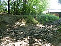
Spring pot of the Lünerner Bach in Frömern, August 2015
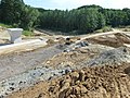
Construction of the flood retention basin, 2015, facing south

On the left new inflow into the flood retention basin under construction, on the right the previous course of the stream
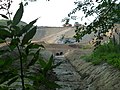
New inflow into the flood retention basin, construction work, August 2015
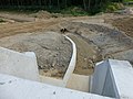
New stream inlet into the flood retention basin, August 2015

Two details of the new flood retention basin, August 2015
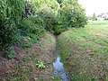
East bank of the Lünerner Bach between Mühlhausen u. Lünern, direction of flow NE, August 2015

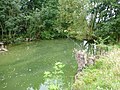
Lünerner Bach west of Lünern, looking east, March 2016
Lünerner Bach in Lünern, direction of flow east, September 2015
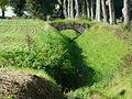
Lünerner Bach, east of Lünern, on the right the Vöhdeweg , October 2014.

Lünerner Bach, shortly before the confluence with the Seseke, August 2015
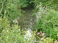
Lünerner Bach, shortly before the confluence with the Seseke, August 2015

Display board at the flood retention basin in the Bimbergtal, August 2017
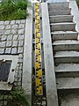
Lünern Bach, level in Lünern = 0 cm, end of July 2017; Level in Lünern = 8 cm, December 31, 2019


.JPG)
Remarks
- ↑ Many spring pots fall dry when there is little rainfall and are therefore referred to as intermittent springs.
- ↑ The (right) east bank in this section is predominantly somewhat higher and steeper than the western one, as is the case with all rivers that flow from south to north in the northern hemisphere. This effect is the result of the so-called. Coriolis force .
- ↑ East flow direction, towards the viewer. Both banks are equally steep. The Coriolis force does not occur in watercourses that flow parallel to latitude.
Web links
Individual evidence
- ↑ a b online tool automatic height profile calculation version 2.0 (beta)
- ↑ a b The Lünerner Bach in the Lippe results report ( page no longer available , search in web archives ) Info: The link was automatically marked as defective. Please check the link according to the instructions and then remove this notice. from 2004 (PDF; p. 27)
- ^ Subsidies from the federal and state governments .
- ↑ Hellweger Anzeiger, August 15, 2015, p. 17.
- ↑ See photo: LB level, end of July 2017.