
Roman Lippe Route
| Roman Lippe Route | |||||||||||||||||||||||||||||||||||||||||||||||||||||||||
|---|---|---|---|---|---|---|---|---|---|---|---|---|---|---|---|---|---|---|---|---|---|---|---|---|---|---|---|---|---|---|---|---|---|---|---|---|---|---|---|---|---|---|---|---|---|---|---|---|---|---|---|---|---|---|---|---|---|
| overall length | 479 km | ||||||||||||||||||||||||||||||||||||||||||||||||||||||||
| location |
|
||||||||||||||||||||||||||||||||||||||||||||||||||||||||
| Starting point |
Xanten 51 ° 40 '2.4 " N , 6 ° 26' 33.4" E |
||||||||||||||||||||||||||||||||||||||||||||||||||||||||
| Target point |
Detmold 51 ° 54 '42.1 " N , 8 ° 50' 21.7" E |
||||||||||||||||||||||||||||||||||||||||||||||||||||||||
| Height difference | 1,032 m up / 1,373 m down | ||||||||||||||||||||||||||||||||||||||||||||||||||||||||
| difficulty | medium mostly flat, inclines between Hermannsdenkmal and Bad Lippspringe |
||||||||||||||||||||||||||||||||||||||||||||||||||||||||
| Traffic volume | mostly car-free | ||||||||||||||||||||||||||||||||||||||||||||||||||||||||
| Website URL | Website of the Römer-Lippe-Route | ||||||||||||||||||||||||||||||||||||||||||||||||||||||||
|
Route
|
|||||||||||||||||||||||||||||||||||||||||||||||||||||||||
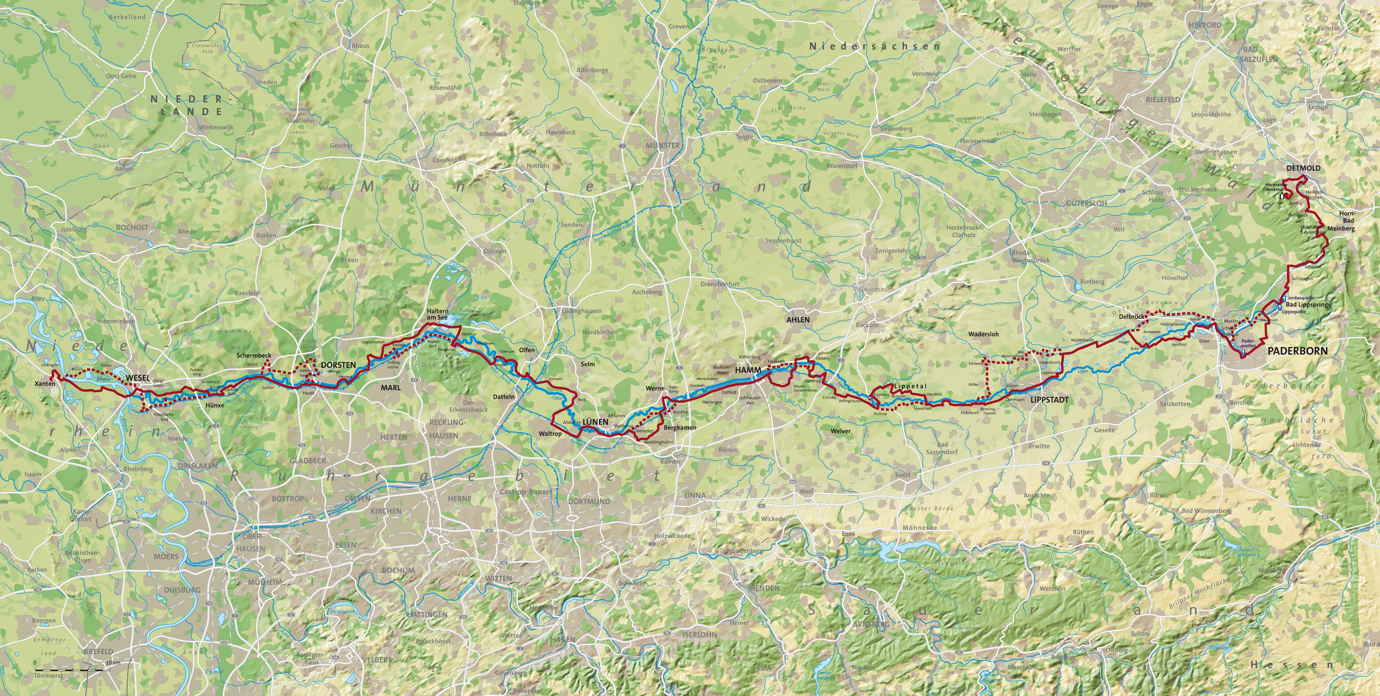
The Römer-Lippe-Route is a 479 km long river cycle path in North Rhine-Westphalia and was opened in April 2013. The route leads from the Hermannsdenkmal near Detmold along the Lippe (Lippia) to Xanten on the Lower Rhine and tries to trace the path of the Roman legions that took part in the Varus Battle (although, according to the latest findings, the battle did not take place near Detmold). This is where the name Römer-Lippe-Route is based . The "Römer-Lippe-Route" is the successor to the Roman route . The total of 479 km lead on the 295 km long main route and 184 km on the 12 thematic loops, which thematize the topics of water experience and Roman culture.
Route


The Römer-Lippe-Route runs largely along the Lippe and a former military road of the Romans , which dates from 12 BC. It was supposed to serve as a shipping route to secure the Lippe and to conquer the Germania on the right bank of the Rhine . The starting point of the route is the Hermannsdenkmal in Detmold. Römerlager along the routes could in Bergkamen- Oberaden ( Römerlager Oberaden ) Olfen ( Römerlager Olfen ), Haltern am See ( FO Römermuseum ) Holsterhausen ( Römerlager Holsterhausen ) Anreppen ( Römerlager Anreppen ) and the in the province Germania inferior preferred Legionslager Vetera be detected at Xanten. In addition, the route has 12 thematic loops with a length of 184 km on the subjects of "Roman culture" and "Water experience".
The total route is 479 km long and runs along the Lippe Valley in an east-west direction.
The thematic loops
The core cycle path has been supplemented by thematic loops that deviate from the main route and rejoin the main path in a loop.
Talleseen loop (approx. 9 km)
The loop leads around Paderborn past the Tallesseen and leads back to the main route at Padersee .
Boker Canal Loop (approx. 14 km)
The Lippe side canal created in the 19th century was used to irrigate the otherwise barren sandy soils of the Senne region. With its lock systems, it is now an important Westphalian cultural monument and, together with the shady rows of trees, offers a real water experience.
Sole spring loop (approx. 23 km)
This loop leads through the health resort Bad Waldliesborn , which u. a. is known for its rich thermal brine springs. The loop leads to the main route via the Liesborn Abbey Museum in Wadersloh.
Nature experience Auenland loop (approx. 9 km)
As part of the nature experience Auenland project, new habitats for animals and plants in the floodplains of Lippe and Ahse as well as observation opportunities and resting places have been created in recent years.
Lippeauen loops (approx. 3.5 km)
The Lippeaue was renatured with the LIFE project Lippeaue as a habitat for endangered animal species and as a retention area for floods. Information boards and two observation towers give you an insight into life in the Shire.
Moated Castle Loop (approx. 5 km)
This loop leads past the medieval Oberwerries Castle and Heessen Castle, which is now a country school home.
Lippe lookout tower loop (approx. 9 km)
While the main route leads over the Römerpark Bergkamen, the loop leads into the meadow landscape with the Lippe observation tower and the nearby ecology station of the Unna district. Here, nature conservation is clearly explained using a cottage garden, a plant education pond and a forest bee educational trail.
Victoria loop (approx. 13 km)
In contrast to the main route, which runs through Haltern am See at the LWL Roman Museum, the loop continues along the Lippe.
Roman trail loop (approx. 39 km)
On this loop, which offers a direct connection on a former railway line between Dorsten and Wesel, you can learn a lot about the everyday life of the Romans and their troubles, which determined the life of the Roman legionaries at the time.
Lippe estuary loop (approx. 18 km)
The mouth of the Lippe has been renatured piece by piece for several years and serves as a species-rich local recreation area for residents and visitors.
Rhine-Auen loop (approx. 11.5 km)
While the main route crosses the Rhine and leads through the Bislicher Insel nature reserve to Xanten, the Rhine-Auen loop continues on the dikes to the right of the Rhine .
Roman water source loop (approx. 30 km)
The loop begins at the end point of the Römer-Lippe-Route and leads, among other things, through the landscape of Sonsbeck Switzerland , a ridge of a former edged moraine . Thematic stations provide information about the settlement history of Colonia Ulpia Traiana , a Roman city in today's Xanten area. Their water supply was partly obtained from springs in the Sonsbeck heights and transported via water pipes with a distance of around 9 km to what was then the ancient city.
Elevation profile
The Römer-Lippe-Route has a relatively flat profile. Only on the first few kilometers between Hermannsdenkmal and Bad Lippspringe are few inclines to be expected when crossing the Teutoburg Forest . The route then runs largely flat through the floodplain landscapes of the Lippe.
Road condition
The route is signposted in both directions. Low inclines and easy-to-drive paths make the route family-friendly; Significant sights, historic town centers, museums as well as thermal and fun pools and other leisure facilities along the way make the route not only interesting in terms of landscape. When traveling the entire route, it is recommended to drive from the east ( Detmold ) to the west ( Xanten ), as there are no more serious inclines after overcoming the Teutoburg Forest. The route runs mainly on separately guided and car-free paths, the surface of which is mostly paved or covered with water-repellent gravel.
Signage
The route is indicated by a white helmet on a red / blue background on a square sign; the helmet represents the Romans, while the lip is represented by a stylized blue river. In addition, the loops have been marked with their own colors. The sign of the "Water Experience Loop" is completely blue and the sign "Roman Culture Loop" is completely red. At intersections with other routes, there are red and white arrow signs with kilometers and locations, as well as the “Römer-Lippe-Route” pictogram. The Römer-Lippe-Route runs on the cycle paths of the NRW cycle path network. The route itself is signposted in both directions with route signs.
Sights along the way
Along the route of the "Römer-Lippe-Route" there are many historical, cultural and natural sights:
- Lippe estuary in Wesel
- Roman city Xanten with archaeological park and old town
- Roman museum in Haltern am See
- Old quarter in Lünen with Persiluhr and ox train
- Bergkamen-Oberaden Roman Camp
- Old town Werne
- Maximilian Park in Hamm
- Lippe locks in Hamm
- Old town Paderborn and Lippstadt
- Lippequelle in Bad Lippspringe
- Hermannsdenkmal and old town Detmold
Places along the route
From west to east, the Römer-Lippe-Route connects the cities and communities Sonsbeck - Xanten - Wesel - Hünxe - Schermbeck - Dorsten - Haltern am See - Olfen - Selm - Waltrop - Lünen - Bergkamen - Werne - Hamm - Welver - Herzfeld - Lippstadt - Delbrück - Paderborn - Bad Lippspringe - Schlangen - Horn-Bad Meinberg - Detmold .
| place | Distance from the starting point
the Römer-Lippe-Route |
|---|---|
| Hermannsdenkmal | 0 km |
| Detmold | 8 kilometers |
| Horn-Bad Meinberg | 20 km |
| Bad Lippspringe | 37 km |
| Paderborn | 50 km |
| Delbruck | 68 km |
| Lippstadt | 92 km |
| Wadersloh | 98 km |
| Lippetal - Hovestadt / Herzfeld | 110 km |
| Lippetal - Lippborg | 122 km |
| Welver | 130 km |
| Ahlen / Dolberg | 140 km |
| Hamm | 153 km |
| Werne | 165 km |
| Bergkamen | 170 km |
| Luenen | 184 km |
| Waltrop | 190 km |
| Selm | 198 km |
| Olfen | 206 km |
| Dates | 214 km |
| Haltern am See | 228 km |
| Marl | 238 km |
| Dorsten | 250 km |
| Schermbeck | 260 km |
| Hünxe | 267 km |
| Wesel | 279 km |
| Xanten | 295 km |
See also
Web links
Individual evidence
- ↑ a b Römer-Lippe-Route on www.nrw-tourismus.de, accessed on January 28, 2018.
- ↑ a b Römer-Lippe-Route at www.adfc-radtourismus.de, accessed on January 28, 2018
- ↑ a b Römer-Lippe-Route on www.ruhr-tourismus.de. Retrieved August 25, 2018 .
- ↑ a b c Figures - Data - Facts - Römer-Lippe-Route. Retrieved December 19, 2017 .
- ↑ Cycle pilot: Römer Lippe Route , accessed on August 24, 2018.
- ↑ Sights by theme - Roman Lippe Route. Retrieved December 19, 2017 .