
Werther (Westphalia)
| coat of arms | Germany map | |
|---|---|---|
.svg)
|
Coordinates: 52 ° 5 ' N , 8 ° 25' E |
|
| Basic data | ||
| State : | North Rhine-Westphalia | |
| Administrative region : | Detmold | |
| Circle : | Gutersloh | |
| Height : | 130 m above sea level NHN | |
| Area : | 35.42 km 2 | |
| Residents: | 11,150 (Dec. 31, 2019) | |
| Population density : | 315 inhabitants per km 2 | |
| Postal code : | 33824 | |
| Area code : | 05203 | |
| License plate : | GT | |
| Community key : | 05 7 54 052 | |
| LOCODE : | DE WXR | |
| City structure: | 6 districts | |
City administration address : |
Mühlenstrasse 2 33824 Werther (Westphalia) |
|
| Website : | ||
| Mayoress : | Marion Weike ( SPD ) | |
| Location of the city of Werther (Westphalia) in the Gütersloh district | ||
 _in_GT.svg) |
||

Werther (Westf.) Is a city in North Rhine-Westphalia , Germany , and belongs to the Gütersloh district . It is located in the Ravensberg hill country on the northern edge of the Teutoburg Forest. Because of the expressionist Peter August Böckstiegel (1889–1951) born and living there , it is also known as Böckstiegelstadt.
geography
Geographical location
Werther lies on the northern slope of the Teutoburg Forest . At this point the ridge is part of the Weser-Ems watershed .
The small town with around 11,500 inhabitants is 10 km from the university town of Bielefeld and is the only town in the Gütersloh district to be assigned to the Ravensberger Mulde . In the north and in the east the city boundary is also the district boundary (partly formed by the Warmenau ), in the north partly the state boundary with the state of Lower Saxony . The urban area has great differences in altitude, the lowest point is at 92 m above sea level. NHN at the inflow of the border ditch into the Warmenau north of Rotenhagen, directly on the border with Lower Saxony and the Herford district. The Hengeberg is 316 m above sea level. NHN the highest elevation.
The Warmenau and Schwarzbach rises in the urban area .
geology

The area of Werther, which lies completely north of the ridge of the Teutoburg Forest, is counted as part of the Ravensberg hill country and consists essentially of clay marl, limestone and sandstone from the Middle Ages, i.e. Triassic , Jurassic and Chalk . The one to two kilometer thick sediments were lifted out in the course of the earth's history and broken up into saddles , hollows , clumps and ditches by mountain-forming processes . In these fracture folds , the rock layers, which used to be undisturbed one above the other, are now arranged side by side and in some cases in tipped over storage. In the deeper subsurface the rocks of the ancient times can be found again.
Nutrient-poor, acidic, stony heather soils ( podsoles ) made of Lower Cretaceous sandstone appear on the ridge . The northeastern upstream hilltops made of shell limestone from the Middle Ages bear shallow, alkaline, clayey-loamy soils ( rendzinen ). The Ravensberg hill country is covered by a flour-like fly dust (loess) from the Ice Age, which has weathered into fertile brown soils (parabraun earths). In some cases, permeable layers prevent the soil water from seeping away. These waterlogged soils (pseudogleye) made of loess are often drained for better arable use. The valleys, which only have their original V-shape or trough shape in places, were mainly transformed into box valleys in the 19th and 20th centuries in order to increase the yield of these grassland locations. Groundwater soils ( gleye ) dominate here, and are filled with water down to the topsoil.
Werther is moderately suitable, but good to very good on slopes, for the use of geothermal heat sources by means of a geothermal probe and heat recovery through heat pump heating (see the adjacent map).
_-_land_utilization.svg)
Expansion and use of the urban area
The city covers an area of 35.32 km². The predominant part consists of agricultural area and forest area, together around 82%, followed by built-up area and traffic area, together around 17%. The greatest extent in north-south direction is about 7.8 km, in east-west direction about 8.3 km.
| Area according to type of use |
Agricultural area |
Forest area |
Building, operational and open space |
Traffic area |
Surface of water |
Sports and green space |
other use |
|---|---|---|---|---|---|---|---|
| Area in km² | 23.86 | 5.20 | 4.13 | 1.81 | 0.20 | 0.22 | 0.07 |
| Share of total area | 67.55% | 14.72% | 11.69% | 5.12% | 0.57% | 0.62% | 0.2% |
Neighboring communities
| Melle - Neuenkirchen | Spenge | |
| Borgholzhausen |  |
Bielefeld |
| Hall |
Werther borders in the east on the independent city of Bielefeld and in the south on the city of Halle (Westphalia) , in the west Borgholzhausen (both belonging to the district of Gütersloh), in the north-west on Melle ( district Osnabrück ) in Lower Saxony and in the north on Spenge ( district Herford ).
City structure

In addition to Werther, Werther consists of the villages of Häger , Isingdorf , Rotenhagen , Rotingdorf , Schröttinghausen and Theenhausen . Only Werther, Häger and Theenhausen are closed localities. The main statute of the city does not distinguish between different localities or districts.
Langenheide lies between Rotenhagen, Rotingdorf and Theenhausen. This is not a summary of these districts, but a place and field name, which is primarily derived from the Langenheide elementary school and the parish hall opposite. There is no village or settlement with that name; but a sports club , the TuS Langenheide 1949 e. V. as well as the CVJM Langenheide and the fire engine of the volunteer fire brigade Langenheide ensure that this place name is well known.
climate
Werther belongs to the temperate climate zone of Central Europe. It is in the range of the sub-Atlantic maritime climate. The winters are mostly mild under the influence of the Atlantic and the summers are moderately warm. The annual mean temperature is around 9-10 ° C.
Due to the location in the sub-Atlantic maritime climate, a humid climate prevails all year round with relatively evenly distributed rainfall. In total, the Werther measuring station has a long-term average of 931 mm of precipitation per year. Thus falls through the rain scavenging activity of the Teutoburg Forest due to orographic rainfall all year significantly more rainfall than in the German middle (700 mm), and significantly more than the south of the Teutoburg Forest, adjacent to the Werther.

|
Climate Werther (134 m)
Source: German Weather Service
|
|||||||||||||||||||||||||||||||||||||||||||||
For the climate in the Ostwestfalen-Lippe region , to which the city belongs, see also the article Climate in Ostwestfalen-Lippe .
history
Werther is mentioned for the first time in a transcript of the Freckenhorster Heberegister before 1009. There a "Bodo von Wartera" is mentioned, who could have lived there even then. The church of Sankt Jacob in Werther with its Romanesque tower and Gothic nave was probably laid in the 12th century.
With the parish of Dornberg, the parish of Werther belonged to the Vogtei Werther in the Sparrenberg district of the Ravensberg county. The "Werther House", first mentioned in the 14th century, became the center of that bailiwick. At that time, Henrich von Cappel was enfeoffed by the Count of Ravensberg. In 1380 the feudal man received the manor "Haus zu Wengeringtorpe" ("Wentrup") and in 1386 "Overbeckinghuys" (Overbeck). The von Cappel and Droste-Erwitte families were entitled to the property until 1508, after which it passed into the hands of the von Hatzfeld family until 1804 . The "right house Werther", designated in 1526, developed from the two manors. This "Haus Werther" forms the core of the "Herrschaft Werther" to which several surrounding farms belonged, which the "Herrschaft von Werther" were obliged to pay taxes and services. The city's old courtyards were mainly located on the old trade route from Bielefeld to Osnabrück.
In 1488, Werther, together with Halle and Borgholzhausen, was already awarded those suitable for soft images , but remained insignificant with its surrounding communities. The inhabited area in 1556 included 44 in Werther, Rotenhagen with Häger (belonging to the "free Hagen") 47, Isingdorf 22, Schröttinghausen 19, Rotingdorf 13 and Theenhausen 12 homes.
At the end of the 16th century, the von Hatzfeld family left the Werther house; since then it has been managed by a tenant.
In 1654, the Great Elector confirmed the privilege of those who were justified by the soft image. This gave Werther trading rights, which, although kept within a very modest framework, nevertheless represented a turning point for Werther's development; there was a closed development and thus a departure from pure agriculture. Even today there are houses in the city center of Werther that bear witness to that turning point.
The award of town charter to Werther by King Friedrich Wilhelm I of Prussia in 1719 was a milestone in the history of the development of the town of Werther. The real importance was not shown in the administrative changes that the granting of city rights brought with it, but in the economic field. The trade barriers fell for the city of Werther, so that traders could now settle in Werther according to their free will. In 1787 the rural communities around Werther had 5568 inhabitants, the town of Werther itself 1013 inhabitants. Around 100 merchants and craftsmen lived here during this time. At the beginning of the 19th century, economic life in the city was no longer determined by trade, but by the craft of cigar makers and linen weavers.
The construction of the small train line to Bielefeld in 1901 gave commercial life a new boost. The narrow-gauge railway (1000 mm) ran up to February 1954 via Dornberg, Schildesche (there connection to Enger ) to Bielefeld district station (route length 14 km). Since then, companies from a wide variety of industries have gained a foothold in Werther. The number of businesses that exist today shows that agriculture is no longer of dominant importance in the town of Werther. The former rural communities, on the other hand, with few exceptions in Häger are poor in industry and have a strong connection to agriculture.
In 1949 the town of Werther had 4391 inhabitants due to the large influx of refugees and displaced persons.
The population of the city and the surrounding rural communities rose steadily. The economy, housing and other facilities in a city of this size experienced a major boom.
In 2009 the city of Werther celebrated its 1000th anniversary.

Incorporations
As a result of the merger of the city of Werther with the communities of the former Werther office (Häger, Isingdorf, Rotenhagen, Rotingdorf, Theenhausen and parts of Schröttinghausen), the new city of Werther (Westf. ) educated. The previous office was dissolved. In 1982, as part of an area change, the reorganization of around 20 hectares ( Nagelsholz ) from the city of Bielefeld to the city of Werther (Westphalia) came into effect, so that the area of the city increased to 35.28 km². The areas had previously been incorporated into the city of Bielefeld in 1971.
Population statistics
_-_population_development.svg)
The following overview shows the population of the city of Werther according to the respective territorial status, with some figures also according to the current territorial status. The figures are census results up to 1970 and 1987 and from 1975 official updates by the State Office for Data Processing and Statistics. The figures from 1975 to 1985 are estimated values, the figures from 1990 are extrapolations based on the results of the 1987 census. From 1871 and 1946, the figures relate to the local population , from 1925 to the resident population and from 1985 to the population at Location of the main residence . Before 1871, the number of inhabitants was determined according to inconsistent survey procedures.
In 1974 the population figures in the entire city and in the city of Werther (Westphalia) with the former boundaries were determined by the State Statistical Office.
|
Werther according to the territorial status at that time
|
Werther according to the current territorial status
|
Denomination statistics
In December 2019, there were a total of 5,543 (48.6%) Protestant and 1,370 (12.0%) Roman Catholic people in Werther . 4,481 (39.3%) people stated a different creed or were non-denominational . In April 2006 a total of 6952 (59.3%) people were Protestant and 1424 Roman Catholic. 3347 (28.55%) people stated a different creed or were non-denominational.
politics
|
Allocation of seats in the
Werther City Council 2014 A total of 36 seats
|
City council
The city council currently has 36 members. In addition, there is the mayor as the council chairwoman. As a result of the local elections on May 25, 2014, the CDU, SPD, Greens, FDP and the Independent Voting Community are currently represented. The following table shows the distribution of seats in the Council and the election results since 1975:
| 2014 | 2009 | 2004 | 1999 | 1994 | 1989 | 1984 | 1979 | 1975 | ||||||||||
|---|---|---|---|---|---|---|---|---|---|---|---|---|---|---|---|---|---|---|
| Political party | Seats | % | Seats | % | Seats | % | Seats | % | Seats | % | Seats | % | Seats | % | Seats | % | Seats | % |
| SPD | 13 | 36.8 | 14th | 39.36 | 11 | 40.18 | 9 | 34.27 | 11 | 34.70 | 12 | 32.85 | 11 | 28.44 | 11 | 33.60 | 15th | 44.13 |
| CDU | 9 | 25.2 | 9 | 25.31 | 10 | 35.65 | 11 | 39.64 | 12 | 39.07 | 15th | 38.20 | 16 | 41.33 | 12 | 36.65 | 15th | 45.18 |
| Green | 7th | 20.2 | 6th | 16.85 | 4th | 15.33 | 4th | 13.06 | 4th | 13.68 | 3 | 9.90 | 2 | 7.44 | - | - | - | - |
| UWG 1 | 5 | 13.3 | 5 | 12.59 | 3 | 8.83 | 3 | 10.18 | 2 | 7.74 | 4th | 11.37 | 4th | 10.65 | 7th | 21.26 | - | - |
| FDP | 2 | 4.5 | 2 | 5.90 | - | - | 1 | 2.84 | 0 | 4.81 | 3 | 7.68 | 4th | 12.14 | 2 | 5.14 | 3 | 10.69 |
| Individual applicants | - | - | - | - | - | - | - | - | - | - | - | - | - | - | 1 | 3.35 | - | - |
| Total 2 | 36 | 100 | 36 | 100 | 28 | 100 | 28 | 100 | 29 | 100 | 37 | 100 | 37 | 100 | 33 | 100 | 33 | 100 |
| voter turnout | 60.7 | 64.94 | 64.47 | 61.79 | 85.18 | 73.51 | 73.89 | 77.66 | 88.69 | |||||||||
1 Independent community of voters, 2 without taking into account rounding differences
mayor
The mayor of the city of Werther has been the administrative lawyer Marion Weike since the municipal elections in 1999 . She was re-elected in the local elections on September 26, 2004 with 67.9%, on August 30, 2009 with 61.58% and on May 25, 2014 with 63.15% of the votes. The following table lists the mayors since 1948.
| Surname | Term of office | comment |
|---|---|---|
| Weike, Marion (SPD) | since 1999 | first full-time mayor of the city, re-elected on September 26, 2004, August 30, 2009 and May 25, 2014 |
| Oberwelland, Martin (SPD) | 1989-1999 | last honorary mayor of the city |
| Venghaus, Heinrich (CDU) | 1979-1989 | |
| Scheele, Wilhelm (SPD) | 1975-1979 | |
| Venghaus, Heinrich (CDU) | 1973-1975 | Election on April 11, 1973 |
| Tusch, Gerhard (CDU) | January 1, 1973 to April 10, 1973 | Provisional performance of duties after the municipal reorganization on January 1, 1973 |
| Venghaus, Heinrich (CDU) | 1971-1972 | |
| Rüter, Heinrich Wilhelm (CDU) | 1961-1971 | |
| Venghaus, Paul (CDU) | 1956-1961 | |
| Riepe, Karl (SPD) | 1952-1956 | |
| Venghaus, Paul (CDU) | 1948-1952 |
Further election results
Werther belongs to the Gütersloh I - Bielefeld III state constituency , in which Georg Fortmeier (SPD) was elected as a direct candidate in the 2010 state election . At the federal level, Werther is the only place in the Gütersloh district to belong to the Bielefeld constituency , in which Lena Strothmann (CDU) was elected as a direct candidate in 2009.
Coat of arms, flag, banner and seal
- The city of Werther was granted permission by the District President in Detmold on November 12, 1973 to display a municipal coat of arms, a banner and a flag. (Main statute § 2) A combination of the former city and office coats of arms (both awarded in 1938) was adopted as the coat of arms.
|
|
Blazon : "In a shield embroidered with red and silver ( white )in the first field three silver (white) 2: 1 triangles , in the second and third fields three red rafters , in the fourth field two silver (white) crossed maces ." |
| Justification for the coat of arms: The three silver triangles in the red field are the basis for the seal of Dietrich von Werth called Edissen (1399), feudal man of Herford Abbey. The three red rafters on a white background stand for the coat of arms of the Grafschaft Ravensberg and symbolize the earlier affiliation of the urban area to the county. The maces are reminiscent of the von Cappel family coat of arms (Werther House). |
.svg)
- Description of the flag: "Red-white-red in a ratio of 1: 3: 1 striped lengthways with the heraldic shield offset from the center to the pole."
- Description of the banner: "Red-white-red in a ratio of 1: 3: 1 striped lengthways with the coat of arms above the center."
- Seal: Werther also has an official seal that shows the town's coat of arms in the inner field and bears the inscription "Stadt Werther (Westf.)".
Culture and sights
theatre
Werther does not have a theater building. The auditorium of the Peter-August-Böckstiegel comprehensive school or the Ev. Used the parish hall.
Museums
The Peter-August-Böckstiegel-Haus in the Arrode district is the birthplace and later home of the expressionist Peter August Böckstiegel . The listed artist house gives an authentic impression of the life and work of Böckstiegel. It is the seat of the Peter-August-Böckstiegel-Stiftung, founded in 2008, which preserves the house and works and keeps them open to the public. In order to do justice to the growing interest in Peter August Böckstiegel (1889–1951) and an appropriate presentation of his works, a new museum building was built in the immediate vicinity of the Künstlerhaus between 2016 and 2018 for € 3.8 million. The building, which opened on August 31, 2018, offers space for (changing) exhibitions and museum education, a lecture hall and a café, and sanitary, technical and administrative rooms have also been created.
On the site of a former farm machinery sales company is the executor veterans Museum , an exhibition of tractors, agricultural machinery and agricultural implements, which were built between 1850 and the 1950s. It was founded in 1989 by the Werther Tractor Veterans Club. All exhibits are privately owned. The tractors are driven out twice a year.
music
Worth mentioning is the men's choir Liedertafel . Every year on May 1st, the association organizes a Maisingen in the Stadtpark in Werther .
Buildings
_Pfarrkirche.jpg)
The Evangelical Parish Church of St. Jacobi is a Gothic hall church from the 14th century. It was renewed in 1743 and expanded to the east in 1876/77. The Romanesque west tower has a Gothic upper floor.
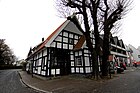
In the center there are still some half-timbered buildings from the 17th and 18th centuries. 18th century, for example Ravensberger Str. 41 from 1650. The so-called Walbaum'sche House from 1621 is located on Venghaussplatz .
The Werther House is an old manor that was first mentioned in 1295. Since 1385 it has been in the fief of the Counts of Ravensberg, who enfeoffed the Counts of Hatzfeld with the estate in 1526 . The Counts of Hatzfeld from Hessen owned the estate until 1803, but never lived in it, but had it administered. In 1840 the house came into the possession of the then district administrator of the Halle district, zur Hellen. From 1843 to 1855 it served, among other things, as a district office . In 1887/88 the buildings were sold to the Weinberg company, which operated a cigar factory there until 1938 . The property of the Jewish family Weinberg was "Aryanized" in 1938 and came to the Herford cigar factory. After it was transferred back in 1951, the Weinberg family sold the house to another cigar manufacturer. Cigars were produced in the house until 1966, and until the end of the 1980s it was still the seat of a cigar distributor. Since 1994 the house has served as a community meeting place and library .

The Storcksche Haus shapes the cityscape on the Alter Markt.

Venghauss'sches house from C.-F.-Venghauss-Platz

Venghauss'sches house from Ravensberger Strasse

View of Ravensberger Strasse in Werther

House Werther
House "Kastanien-Bartling"


_Innenstadt.jpg)
_Haus_Werther.jpg)

_Talbruecke.jpg)
The listed viaduct of the former small railway is located on the Talbrückenweg.
Parks
Werther has an approximately 1.5 hectare publicly accessible park in the form of a former estate park at Haus Werther. In addition, the urban area is part of the TERRA.vita nature park , formerly the Northern Teutoburg Forest-Wiehengebirge nature park.
Natural monuments and nature reserves
In the park of the Werther House there is a columned oak classified as worthy of protection . In addition, Werther has no significant natural monuments and no designated nature reserves.
Regular events
- The Böckstieg run of the LC Solbad Ravensberg took place in September 2007 for the fourth time. It symbolically ties in with PA Böckstiegel's youth, where he had to walk the route from Werther to Bielefeld every day as part of his painting apprenticeship.
- The city festival in Werther (since 2008 under the name Kukuk ) has been taking place on the second weekend in May for 25 years.
- The Christkindl market in Werther traditionally takes place on the third weekend of Advent in December.
- The Jacobi live is a modern service for young and old and is held every third Sunday of the month at 18.00 in the Jacobi Church instead.
- The Schloss-Open of the Werther chess club is currently the most important chess tournament in East Westphalia and traditionally takes place on the weekend before Easter in Haus Werther.
- Maisingen of the men's choir MGV Liedertafel
Culinary specialties
The Bossert bakery in Werther is known far beyond the city limits for its box pickers .
Economy and Infrastructure
traffic
Road traffic
The North Rhine-Westphalian state roads 782 and 785 cross in Werther. State road 756 and the north-west A 33 are easily accessible via these roads .
Rail and bus transport
_ZOB_2011.jpg)
The nearest train stations are Bielefeld Hbf and Halle (Westf.) On the Haller Willem railway line . Since the 2014 timetable change, the bus station has been served by regional buses to Bielefeld every 15 minutes . There are other bus connections to Spenge , Halle and Borgholzhausen . Some districts are served by a citizens' bus. The hourly buses from Werther to Halle have a train connection to Osnabrück at the station.
Werther has been part of the “Teuto OWL” ( OWL Verkehr GmbH) network tariff in the WestfalenTarif since August 1, 2017 . From Halle, a transitional tariff to the Verkehrsgemeinschaft Osnabrück (“VOS plus” tariff) can be used for the Haller Willem in the direction of Osnabrück . This tariff applies to bus services only in the city of Halle, not to Werther ZOB.
Foot traffic
The Hermannsweg , a hiking trail from Rheine to Velmerstot in Lippe , runs along the ridge of the Teutoburg Forest, on the southern border of the municipality .
The Talweg begins at the central bus station (ZOB) in Werther . The long-distance hiking trail , supervised by members of the Teutoburg Forest Association , leads over 50 kilometers to Bad Oeynhausen train station .
Air traffic
Bielefeld, the next larger city, does not have a commercial airport. Therefore, a little longer journeys are to be accepted, which are, however, comparable in terms of time required to the journeys in a large city. There is a choice of 4 regional airports within one to one and a half hours by car, which means that the number of destinations that can be reached by direct flights is quite high. The Muenster / Osnabrueck Airport is located about 59 km away, the Paderborn / Lippstadt Airport 72 km away. The Dortmund airport is about 100 km, that of Hanover is around 117 km away.
media
Print media
The Haller Kreisblatt and a local edition of the Westfalen-Blatt from Bielefeld appear as daily newspapers from Monday to Saturday . The Westfalen-Blatt gets its cover from the Bielefelder Zentralredaktion, while the Haller Kreisblatt gets the supraregional part of the Bielefelder Zeitung Neue Westfälische from a cooperation group. Both newspapers report in the local section from all the communities in the old district of Halle, including Werther. In addition, the OWL am Sonntag newspaper , an offshoot of the Westfalen-Blatt , is published free of charge on Sundays . Monthly, edited by Haller circle sheet City magazine is also free Werther News and the bimonthly published by the Panorama publishing and advertising mbH city magazine experience Werther , the latter an offshoot of the Westfalen-sheet.
Radio and television
Werther belongs to the reporting area of the regional studio Bielefeld of the WDR . Furthermore, Werther belongs to the broadcasting area of Radio Gütersloh , which it covers in the reporting as local radio.
Public facilities
The city of Werther offers services for the citizens of Werther in its facilities. In addition to the offices, the town hall also houses a police station, which is only temporarily manned.
In addition to the city library, there has been a community meeting place in Haus Werther since 1994, a community center in the Häger district and - again in Werther - the “Funtastic” children's and youth center.
There are also three fire engines from the Werther volunteer fire brigade , one of which is located in the town of Werther, another in the Häger district and the third in Langenheide. The Wertheran fire brigade has existed since 1875, making it the oldest in the Gütersloh district.
There is also an outdoor pool in Werther.
education
The city offers three types of school in three schools. As of 2011, these are a primary school network with two locations (Mühlenstrasse and Langenheide) with around 530 students, who are taught by 32 teachers, a grammar school (EGW - Evangelisches Gymnasium Werther) with around 730 students (in) n, which are taught by 63 teachers, and a comprehensive school (PAB - Peter-August-Böckstiegel comprehensive school). Since the comprehensive school is located at one location each in Borgholzhausen and Werther and is mathematically assigned to Borgholzhausen, no pupil numbers or teacher numbers are available for the Werther part of the comprehensive school. Facilities in neighboring cities and municipalities must be used for other types of school.
Established businesses
- Pikeur Reitmoden FW Brinkmann GmbH , manufacturer of riding clothing
- Bankverein Werther , branch of VerbundVolksbank OWL eG
- Potato Manufactory Pahmeyer GmbH & Co. KG, Potato Manufactory
- Hermann Bleikamp GmbH, sleeping comfort
- Glamento GmbH, glass building materials, industrial floors
- Schröder Maschinenbau GmbH, Food Processing, Packaging
- Poppe + Potthoff GmbH, Rohrwerk and supplier of automotive system components
- WERTHER - Die Möbelmanufaktur Oberwelland GmbH & Co. KG, home furniture manufacturer
- act'o-soft GmbH Informationssysteme, manufacturer of POS software for fashion retail
- trainsform GmbH, organizational consulting, change management and leadership development
- Hauck Heat Treatment GmbH, services in the field of heat treatment and surface finishing of metals
Personalities
Honorary citizen
Honorary citizenship rights (by special council resolution) have not yet been granted. Since 1973, 24 people have been awarded the Federal Order of Merit (or Federal Cross of Merit) (as of June 10, 2008).
sons and daughters of the town
- Wilhelm Wallbaum (1876–1933), trade union official and politician
- Moritz Weinberg (1888–1944), lawyer
- Peter August Böckstiegel (1889–1951), sculptor and painter
- Richard Toellner (1930–2019), medical historian
- Helga Gießelmann (* 1949), politician and member of the state parliament in North Rhine-Westphalia
- Günter H. Müller (* 1949), composer
- Ulrich Radtke (* 1955), geographer and rector of the University of Duisburg-Essen
- Tilmann Meyer zu Erpen (* 1959), dressage rider
- Christina Sussiek (* 1960), track and field athlete
- Sven Lefkowitz (* 1968), politician and member of the Rhineland-Palatinate state parliament
- Oliver Krüger (* 1975), biologist
People connected to the city
- Monte Jaffe (* 1940), opera singer ( bass baritone ), lives in Werther
- Jürgen Buchmann (* 1945), writer and philologist, lives in Werther
- Jan-Fiete Buschmann (* 1981), national handball player
- Aytürk Gecim (* 1995), national futsal player
- Nadine Jarosch (* 1995), artistic gymnast , grew up in Werther
Trivia
Werther is the namesake of the caramel sweets Werther's Original (formerly: Werthers Echte). In 1909 the confectioner Gustav Nebel invented the famous candy in what was then the "Werther'schen Zuckerfabrik". A stylized silhouette of the city of Werther still adorns the packaging of the sweets that are made today in Berlin ( Storck company ).
literature
- Erika Stieghorst: The "strong house Werther" - old noble residence and moated castle on the Schwarzbach. In: Heimat-Jahrbuch Kreis Gütersloh 1987, pp. 85–90.
Web links
- City of Werther
- Werther (Westphalia) in the Westphalia Culture Atlas
Individual evidence
- ↑ Population of the municipalities of North Rhine-Westphalia on December 31, 2019 - update of the population based on the census of May 9, 2011. State Office for Information and Technology North Rhine-Westphalia (IT.NRW), accessed on June 17, 2020 . ( Help on this )
- ^ Geological Service North Rhine-Westphalia, Geoscientific Community Description Werther (Westf.) ( Memento from December 3, 2013 in the Internet Archive )
- ↑ Geological Service NRW: Using geothermal energy - geothermal study provides planning basis. ( Memento of September 14, 2005 in the Internet Archive ) (PDF; 369 kB).
- ↑ a b Main Statute of the City of Werther (Westphalia) December 27, 1999 in the version of the 1st amendment of January 28, 2005.
- ↑ [1]
- ^ Federal Statistical Office (ed.): Historical municipality directory for the Federal Republic of Germany. Name, border and key number changes in municipalities, counties and administrative districts from May 27, 1970 to December 31, 1982 . W. Kohlhammer, Stuttgart / Mainz 1983, ISBN 3-17-003263-1 , p. 322 .
- ^ Ministry of the Interior of the State of North Rhine-Westphalia, Citizen Service: Bielefeld Law, see § 5.
- ↑ Municipal statistics of the state of North Rhine-Westphalia: population development 1816–1871 . State Statistical Office of North Rhine-Westphalia, Düsseldorf 1966, p. 209.
- ↑ Municipal statistics of the state of North Rhine-Westphalia: population development 1871–1961 . State Statistical Office of North Rhine-Westphalia, Düsseldorf 1964, pp. 428–429.
- ^ The resident population in the communities of North Rhine-Westphalia 1970: Results of the census on May 27, 1970 . State Statistical Office of North Rhine-Westphalia, Düsseldorf 1972, p. 45.
- ^ Special series on the 1987 population census in North Rhine-Westphalia, Volume 1.1: Population, private households and employed persons . State Office for Data Processing and Statistics North Rhine-Westphalia, Düsseldorf 1989, p. 110.
- ^ State database North Rhine-Westphalia.
- ↑ Martin Bünermann, Heinz Köstering: The communities and districts after the municipal territorial reform in North Rhine-Westphalia . Deutscher Gemeindeverlag, Cologne 1975, ISBN 3-555-30092-X , p. 99 and 101 .
- ↑ City of Werter in facts and figures , accessed on April 13, 2020
- ↑ State database NRW; Election results for the municipality code 05754052.
- ↑ State Office for Data Processing and Statistics: Local elections.
- ↑ VoteManager City of Werther (Westphalia)
- ↑ a b Information from the electoral office of Werther, Mühlenstr. 2, 33824 Werther (Westphalia), June 10, 2008.
- ↑ a b Heraldic symbols tell district history. (PDF; 1.1 MB) In: Gütersloh district website. P. 1 , accessed on October 11, 2019 .
- ↑ Matthias Meyer zur Heyde: The shrine on the meadow . In: Westfalen-Blatt . ( westfalen-blatt.de [accessed on August 29, 2018]).
- ↑ Klaus-Peter Schillig: "Neighbor Boy" is now the museum boss . In: Westfalen-Blatt . ( westfalen-blatt.de [accessed on August 29, 2018]).
- ^ Museum Peter August Böckstiegel. Accessed August 29, 2018 .
- ^ Regional Association Westphalia-Lippe: Park at Haus Werther in LWL GeodatenKultur
- ↑ Line 66 to Spenge previously 89. (PDF) teutoowl.de, accessed on September 4, 2019 .
- ↑ Line 61 to Halle. (PDF) teutoowl.de, accessed on January 5, 2019 . , City of Werther, transport links, etc. a. Spenge and Borgholzhausen. stadt-werther.de, accessed on January 5, 2019 .
- ^ Line 62 to Borgholzhausen / Werther. (PDF) teutoowl.de, accessed on September 4, 2019 .
- ↑ Lines 60 + 98 + 160 to Theenhausen / Neuenkirchen. (PDF) teutoowl.de, accessed on September 4, 2019 .
- ↑ www.egwerther.de
- ^ State office for data processing and statistics North Rhine-Westphalia, municipal profile Werther (Westphalia).