Warmenau (river)
| Warmenau | ||
|
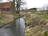
The dammed Warmenau in front of the Martmühle in Spenge |
||
| Data | ||
| Water code | EN : 4666 | |
| location | District of Gütersloh and District of Herford , North Rhine-Westphalia ; District of Osnabrück , Lower Saxony ( Germany ) | |
| River system | Weser | |
| Drain over | Else → Werre → Weser → North Sea | |
| source | at the Teutoburg Forest in Werther 52 ° 4 '47 " N , 8 ° 25' 3" E |
|
| Source height | approx. 122 m above sea level NHN | |
| muzzle | to Groß Aschen in the Else coordinates: 52 ° 11 '18 " N , 8 ° 30' 23" E 52 ° 11 '18 " N , 8 ° 30' 23" E |
|
| Mouth height | approx. 65 m above sea level NHN | |
| Height difference | approx. 57 m | |
| Bottom slope | approx. 3.1 ‰ | |
| length | 18.5 km | |
| Catchment area | 78.926 km² | |
| Left tributaries | Graben Vossheide , Wissmannsbach , Hobebach , Krumkebach , Spenger Mühlenbach , Eselbach | |
| Right tributaries | Spenger Mühlenbach | |
| Medium-sized cities | Melle | |
| Small towns | Werther , Spenge | |

The Warmenau is an 18.5 km long, southern and right tributary of the Else . It rises in Werther in North Rhine-Westphalia , flows largely on the borders of the Westphalian districts of Gütersloh and Herford to the Lower Saxony district of Osnabrück and flows on the border from Melle (Lower Saxony) to Bünde (Westphalia).
geography
course
The Warmenau rises in the Westphalian district of Gütersloh on the northeastern roof of the Teutoburg Forest. Its source is in the north of the city of Werther at about 122 m above sea level. NHN between Gerhart-Hauptmann- Strasse in the west, which is located in a residential area, and Esch Strasse in the east, which runs through an industrial park . The Schwarzbach rises 2.3 km southwest of the Warmenau spring south of the Werther town center .
Initially, the Warmenau flows north between the rural Werther districts of Häger in the east and Rotenhagen in the west. When the Vossheide trench flows into it , it reaches the border with Lower Saxony, on which it lies between Hengstenberg , located in the Westphalian district of Herford , a locality of the district of Bardüttingdorf belonging to the city of Spenge , and Neuenkirchen , a district of the Lower Saxony district of Osnabrück City of Melle , which runs in the northwest.
After the Warmenau has flowed for around 400 m only on the Westphalian side before Hengstenberg, it passes the Königsbrück Castle ( 86.1 m ), which is located on the Lower Saxony side, a little before the confluence of the Wißmannsbach at Bach river kilometer 11.4 , from where it follows Northeast pans. After then flowing into the Hobebach (Lower Saxony) and passing the opposite Heinrichsee ( 79.5 m ), it flows between the Spenger district of Wallenbrück in the east-southeast and Schiplage-St. Annen , a district of Neuenkirchen in the west-north-west. Shortly afterwards, the Warmenau passes the Warmenau estate ( 76.5 m ) located on the Lower Saxony side at the river kilometer 7.5 and feeds its moat; here the Warmenau passes under a house on the national border.
After the confluence of the Lower Saxon Krumkebach stream , the Warmenau runs entirely in Lower Saxony for about 350 m and then flows back to the state border. Then it takes up between the Spenger district Nordspenge in the south-southeast and Hoyel , a locality of the Meller district Riemsloh , in the north-northwest the Spenger Mühlenbach and the Eselbach . Then the Warmenau passes the Martmühle ( 74 m ) and the settlement of Balgerbrück ( 72 m ), both of which are located in the Mell area. It then flows between Klein-Aschen , a locality of the Spenger district of Hücker-Aschen , and the Meller district of Groß Aschen in the west, only to run again shortly afterwards along a 1 km stretch in Lower Saxony.
Then the Warmenau flows at about 65 m altitude into the Werre tributary Else coming from the west and flowing there on the national border - at the Else river kilometer 15.3). Opposite its mouth is the Ahle district of the city of Bünde in the Westphalian district of Herford .
Catchment area and tributaries
The catchment area of the Warmenau is 78.926 km². It extends in North Rhine-Westphalia and Lower Saxony between the Teutoburg Forest and the Else in the Ravensberger Mulde . The tributaries of the Warmenau include (viewed downstream):
| Surname | page | Length ( km ) |
Source | Muzzle | Stat. ( km ) |
EZG ( km² ) |
GKZ |
|---|---|---|---|---|---|---|---|
| height ( m above sea level ) | |||||||
|
Graben Vossheide (Grenzgraben) |
Left | 2.9 | 138 | 90 | 13.4 | 4666-16 | |
| Wissmannsbach | Left | 4.2 | 112 | 81.5 | 10.6 | 4666-18 | |
|
Hobebach (Howebach) |
Left | 4th | 111 | 78.6 | 8.7 | 3.402 | 4666-2 |
| Krumkebach | Left | 3.5 | 89 | 75.5 | 6.9 | 4666-32 | |
| Spenger Mühlenbach | right | 6.9 | 127 | 73.9 | 5.2 | 4666-4 | |
| Donkey brook | right | 3.1 | 103 | 73.2 | 4.8 | 4666-92 | |
Cities
On its way from the source to the mouth, the Warmenau flows through the areas of the following cities, or it runs along their borders (viewed downstream):
- Werther , Gütersloh district, North Rhine-Westphalia
- Spenge , Herford district, North Rhine-Westphalia
- Melle , district of Osnabrück, Lower Saxony
Nature reserves
The Warmenau flows through or grazes two nature reserves (viewed downstream):
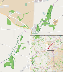
- The Turenbusch nature reserve ( CDDA no. 165975) is located in the urban area of Spenge - immediately east of the border with Lower Saxony. It has been designated since 1989 and covers 29.05 hectares . The valley of the Warmenau is here at Bardüttingdorf as a typical Siek for the Ravensberger Land . In addition to alluvial forests ( alder forest ), wetlands and green meadows, the Siek includes several other flowing and still waters as well as beech forests on the valley slopes . The smaller rivers that flow into it run in natural notch valleys that have not been transformed into the Siek. The European tree frog is the only place in the Herford district in the nature reserve .
- The nature reserve Warmenau (CDDA No. 166170; HF-014) is 27.02 hectares and is also located in the Spenger urban area - immediately southeast of the border with Lower Saxony. It has been designated since July 1, 1989 and consists of two spatially separated and closely successive partial areas; Martmühle and Strangfeld. It is a natural floodplain in the valley of the meandering Warmenau, which is cut about 2 m deep into the landscape. There is a small body of still water in the wet grassland along the stream.
history
The Warmenau marked the border between France and the Kingdom of Westphalia between 1807 and 1811 and was the state border between the Kingdom of Hanover and the Prince Diocese of Osnabrück and Prussia for a long time before and after .
gallery

The Warmenau after the flow of the Martmühle in Spenge ; also here on the national border
|
Individual evidence
- ↑ a b c d e German basic map (DGK 5) in Topographical Information Management, Cologne District Government, Department GEObasis NRW ( information )
- ↑ a b c Topographical Information Management, Cologne District Government, Department GEObasis NRW ( information )
- ↑ a b c d Water directory of the State Office for Nature, Environment and Consumer Protection NRW 2010 (XLS; 4.67 MB) ( Notes )
- ↑ Stat. = Water stationing in Topographical Information Management, Cologne District Government, Department GEObasis NRW ( information )
- ↑ orifice layer (at / near) the tributaries according to the flowing water kilometrage of Warmenau
- ↑ For a better overview and sorting downstream, a hyphen has been inserted for each river in the water code number (GKZ) after the number "4666", which stands for the Warmenau .
- ↑ a b Map services of the Federal Agency for Nature Conservation ( information )
See also
Web links
- River information system ( Memento from August 8, 2012 in the Internet Archive )
- "Warmenau (River)" nature reserve (HF-013) in the specialist information system of the State Office for Nature, Environment and Consumer Protection in North Rhine-Westphalia


