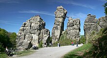
Hermannsweg


The 156 kilometer long Hermannsweg , named after Hermann the Cherusker , also known as Arminius ( Varus Battle 9 AD), is considered one of the most beautiful high-altitude trails in Germany and runs over the ridge of the Teutoburg Forest . The path was set up in 1902, a good 25 years after the completion of the Hermann Monument , and is marked with a white H over its entire length . Together with the Eggeweg the Hermannsweg forms the track trail Hermannshöhen . The Teutoburger-Wald-Verein e. V. based in Bielefeld. Since 2008, the Hermannsweg has been recognized as a predicate hiking trail.
course
The Hermannsweg begins in Rheine and leads to the 441 m high rock group of the Lippe Velmerstot and then to Leopoldstal . Along the way you come across sights such as the Dörenther cliffs with the crouching woman , the Iburg Castle , the Ravensburg near Borgholzhausen , the Sparrenburg in Bielefeld, the Alexander Church in Oerlinghausen, the Hermannsdenkmal , the Berlebeck Adlerwarte and the Externsteine . The largest places that the trail crosses are Tecklenburg , Bad Iburg , Bielefeld and Oerlinghausen . On the viaduct Lämershagen the Hermannsweg crosses the motorway at Bielefeld A 2 in Tecklenburg the highway A1 .
Hermannslauf
In parts, the Hermannsweg is part of the running route of the annual Hermannslauf , a 31.1-kilometer fun run that starts at the Hermannsdenkmal and ends at the Sparrenburg .
Hermannsweg has to give way to the quarry
The Hermannsweg will be relocated in the area of the Lienen- Höste quarry . After the path in the Lengerich area has not been able to lead over the partially dismantled ridge for years due to limestone mining, the path will now also be relocated in Lienen.
For the expansion of the quarry within the scope of the permits from 1998/1999, valuable orchid-rich woodruff beech forest will be cleared - also one of the last areas that bear witness to the Niederwald farming method in the local area.
See also
literature
The hiking map of the Hermannsweg on a scale of 1: 25,000 is a summary of four topographical leisure maps of the state survey office of North Rhine-Westphalia. The map is available from many tourist offices and bookshops along the way or directly from the publisher.
There is also a hiking guide The Hermannsweg , which gives directions with exact kilometers, interesting facts about the nearby places with numerous addresses and telephone numbers as well as interesting sights along the way. This book is published by the Teutoburg Forest Association.
- Hiking map of the Hermannsweg . 1: 25,000. Bookbindery Probst, Rheine 2012, ISBN 978-3-00-038165-2 .
- Hiking map of the Hermannsweg . 1: 50,000. Bookbinding Probst, Rheine 2005, ISBN 978-3-00-026122-0 .
- Hiking map Hermannsweg . 1: 25,000. Publicpress-Verlag, Geseke 2006, ISBN 978-3-89920-191-8 .
- Conrad Stein, Marie-Luise, Dieter Großelohmann: Hermannsweg - Eggeweg. Over the Hermannshöhen through the Teutoburg Forest and Egge Mountains. Conrad Stein Verlag, Welver 2010, ISBN 978-3-86686-164-0 .
- Horst Gerbaulet: Experience Hermannsweg - western part: hiking from Rheine to Bielefeld. With maps 1: 35,000. tpk-Verlag, Bielefeld 2010, ISBN 978-3-936359-14-5 .
- Horst Gerbaulet: Experience Hermannsweg - eastern part: hiking from Bielefeld to Velmerstot. With maps 1: 25,000. tpk-Verlag, Bielefeld 2014, ISBN 978-3-936359-57-2 .
- Karsten Mosebach ; Bernhard Vollmer; Timo Kluttig: Teutoburg Forest: along the Hermannsweg . Tecklenborg, Steinfurt 2014, ISBN 978-3-944327-14-3 (135 pages).
Web links
- www.hermannsweg.de/links.html - Collection of links to sights, routes, photos, etc.
- www.lesum.de/juling/wanderkoenig/?Wandertouren___Hermannsweg - detailed route description
- www.wanderbaren-deutschland.de - hiking portal with the Hermannsweg as route no.1
- www.hermannshoehen.de - Informative pages of OstWestfalenLippe Marketing GmbH
- Horst Gerbaulet: Experience Hermannsweg. Geographical Commission for Westphalia, 2008.
- The course of the Hermannsweg in the OpenStreetMap
Individual evidence
- ↑ Horst Gerbaulet: Experience Hermannsweg. Geographical Commission for Westphalia, 2008.
- ↑ by Falko Prünte: Hermannsweg has to avoid the quarry - relocation of the hiking trail also in Lienen-Höste - Citizens' Initiative Pro Teuto e. V. Accessed on February 18, 2019 (German).
- ↑ Hendrik Steinkuhl: In the middle of the night on the lookout. In: Westfälische Nachrichten. Aschendorff Medien GmbH & Co. KG, January 8, 2015, accessed on May 20, 2020 .
Coordinates: 51 ° 54 ′ 39.9 " N , 8 ° 50 ′ 46.6" E


