
Eggeweg


The Eggeweg is a 70 km long hiking trail in the Eggegebirge in North Rhine-Westphalia . It forms part of the European E1 long-distance hiking trail in Germany. Together with the Hermannsweg , the Eggeweg forms the Hermannshöhen hiking trail . Since 2004, the Eggeweg is as predicate trail excellent. The path is marked with a white X (or E1 ) over its entire length .
Course and infrastructure
The path supervised by the Eggegebirgsverein (EGV) begins at the Externsteinen in Holzhausen-Externsteine and leads from north to south to Niedermarsberg in the Sauerland . Sights on its course include the Silberbachtal with the Silbermühle, the Lippische and the Prussische Velmerstot , the old ore mines on Rehberg, the ruins of the Iburg , the old railway near the Karlschanze, the Teutonia cliffs , the observation tower Bierbaums Nagel and the urban desert of Blankenrode . The largest places on the way are Horn-Bad Meinberg , Bad Driburg and Marsberg .
Sections
The Eggegebirgsverein differentiates between the following sections:
- Externsteine - Iburg (23 km)
- Iburg - Borlinghausen (Bierbaums Nagel) (22 km)
- Borlinghausen - old town Blankenrode - Diemeltal (26 km)
Refuges
23 refuges provide hikers with opportunities to rest and protect themselves from rain showers.
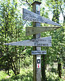
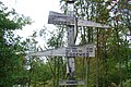
signpost
- Signposts along the Eggeweg from north to south

Junction Sandebeck
Feldromer Berg
Rehberg

Trötenberg, Scholandstein

Sachsenborn, bones

Driburger Hut

Iburg hiking car park


Rescue points
Along the Eggeweg there were 28 rescue points with a unique identifier, i. H. Number and name created. They are used to indicate the location as precisely as possible in the event of danger so that the rescue workers can find the scene of the accident promptly and reliably. The rescue points are reported to the emergency call center (112).
- Silver mill
- Lippischer Velmerstot
- Prussian Velmerstot
- Hooked hut
- Black cross
- Rehberghütte
- Bone hut
- Heinrich Heine Hut
- Driburger EGV hut
- Beautiful view
- Klusenberg Hut
- Radbaum Hut
- Herbram Forest
- Asselner Hut
- Paderborner Berg Hut
- Willebadessener hut
- Johann Kiene Hut
- Old railroad hut
- Krollhütte
- Borlinghauser Hut
- Bördeweg needle
- Roters oak hut
- Mittelwald Hut
- Blankenroder hut
- Felsberg hut
- Oesdorf village square
- Essentho town center
- Marsberg town hall
history
A path already ran over the ridge of the Egge Mountains in prehistoric times. Based on this former trade and military route, the Eggegebirgsverein, founded in 1900, developed today's hiking trail at the beginning of the 20th century, initially as a route from Velmerstot to Bonenburg . The path was later extended to the Externstein in the north and to Niedermarsberg in the south.
2004 Eggeweg was one of the first three German trails the quality seal "quality trail Walking in Germany" of the German Hiking Association as a predicate trail excellent. In the Hermannshöhen project , the path was connected in 2004 with the Hermannsweg in the Teutoburg Forest, which adjoins it to the north to form a 226 km long ridge path .
See also
literature
- Eggegebirgsverein (ed.): Eggeweg X. Section of the European long-distance hiking trail E1. Eggegebirgsverein, Bad Driburg, 1st edition, 1998. (Brochure, updated extract from the Lippert hiking guide)
- Willy Lippert, Lothar Lippert: The Eggegebirge and its foreland. Hiking guide. Eggegebirgsverein (ed.), Bad Driburg, 5th edition, 1996. pp. 146–188.
- Horst Gerbaulet: Eggeweg Experience - Hiking from the Externsteinen to Marsberg Bielefeld 2011, ISBN 978-3-936359-46-6
- Hiking map - Leporello Eggeweg , Publicpress-Verlag Geseke, 1: 25,000, ISBN 978-3-89920-384-4
- Hermannsweg - Eggeweg , Conrad Stein Verlag, Welver 2013, ISBN 978-3-86686-419-1
Individual evidence
- ↑ http://www.eggeweg.de/
- ↑ a b c Willy Lippert, Lothar Lippert: The Eggegebirge and its foreland. Hiking guide. Eggegebirgsverein (ed.), Bad Driburg, 5th edition, 1996. p. 146.
- ↑ http://www.eggegebirgsverein.de/69-Wege/109-Rettungspunkte-am-Eggeweg.html
- ↑ Gerhard Herdam: A look into the club's history. In: Festschrift 100 years Eggegebirgsverein 1900–2000. Eggegebirgsverein, Bad Driburg, 2000.
- ^ Association of German Mountain and Hiking Associations: Hiking trails also need sponsors - Eggeweg, Frankenweg and Kellerwaldsteig are excellent.
Web links
Coordinates: 51 ° 52 '2.5 " N , 8 ° 55' 9.4" E