
Silberbach (Heubach)
| Silberbach | ||
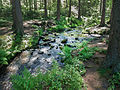
 Silberbach near Feldrom |
||
| Data | ||
| Water code | DE : 45642 | |
| location | North Rhine-Westphalia , Germany | |
| River system | Weser | |
| Drain over | Heubach → Emmer → Weser → North Sea | |
| source | South of Feldrom 51 ° 48 ′ 55 ″ N , 8 ° 56 ′ 35 ″ E |
|
| Source height | approx. 360 m above sea level NN | |
| muzzle | At Heesten , west of Vinsebeck Coordinates: 51 ° 51 '21 " N , 9 ° 0' 24" E 51 ° 51 '21 " N , 9 ° 0' 24" E |
|
| Mouth height | approx. 170 m above sea level NN | |
| Height difference | approx. 190 m | |
| Bottom slope | approx. 17 ‰ | |
| length | 11.3 km | |
| Catchment area | 18.852 km² | |
.jpg) Headwaters south of Feldrom |
||
The Silberbach is an approximately 11 kilometer long tributary of the Heubach in the south of the Lippe district , North Rhine-Westphalia .
course
The stream rises between the villages of Kempen and Feldrom , which belong to Horn-Bad Meinberg . In the Silberbachtal it flows at the foot of the Velmerstot over sandstone cliffs to Leopoldstal . Between Heesten and Vinsebeck it flows into the Heubach , which flows into the Emmer in Steinheim .
Surname
Originally the brook was called Möllenwasser. The name Silberbach comes from (minor) silver finds in the years 1711 to 1712.
history
The historical border between the Principality of Lippe and the Prussian Paderborn , as well as the geographical dividing line between the Teutoburg Forest and the Egge Mountains, was roughly based on the course of the stream .
After the Thirty Years War , the border disputes were resolved in 1658 with the Lippspringischen original comparison . There it says, among other things, as far as the Möllenwasser, so designed that the Böckenberg as far as the Kattenbeke with Holtz and Heide gantz and at least Lippisch, but all of the Veldt Romans remain their companions ...
Mills
Mills used water power: the first concession was awarded in 1612 by the Lippe rulers. The blacksmith annually delivered an ax to the princely rent chamber . Up to seven mills and forges still existed at the beginning of the 19th century . In the upper reaches there were three grinding mills , up to four grinding mills and two fulling mills . Today the remains of the silver, the Boll and a grinding mill still stand. The Silbermühle is the former “packing house” in which the silver ore was once washed out. It was converted into a grinding mill in 1711, which was soon called the silver mill. In 1895 the miller received the license to set up an inn. The mill continued to operate until 1927.
fauna
Specially protected animal species that live in the Silberbachtal:
Silberbachtal

Footnotes
- ↑ a b Topographic map 1: 25,000
- ↑ a b Topographical Information Management, Cologne District Government, Department GEObasis NRW ( Notes )
Web links
- "Silberbachtal mit Ziegenberg" nature reserve in the specialist information system of the State Office for Nature, Environment and Consumer Protection in North Rhine-Westphalia