Leopoldstal
|
Leopoldstal
City of Horn-Bad Meinberg
Coordinates: 51 ° 50 ′ 43 " N , 8 ° 58 ′ 13" E
|
|
|---|---|
| Height : | 242 m |
| Area : | 6.77 km² |
| Residents : | 1780 (December 31, 2015) |
| Population density : | 263 inhabitants / km² |
| Incorporation : | January 1, 1970 |
| Incorporated into: | Bad Meinberg-Horn |
| Postal code : | 32805 |
| Area code : | 05234 |
|
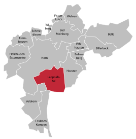
Location of Leopoldstal in Horn-Bad Meinberg
|
|
Leopoldstal is a district in the south of Horn-Bad Meinberg in the Lippe district , North Rhine-Westphalia. The place is in the valley east of the Lippe Velmerstot . There is a stop of the same name in the village on the Herford-Altenbeken railway line . The Silberbach with the Silbermühle also largely belongs to Leopoldstal. Leopoldstal had 1,780 inhabitants on December 31, 2015.
history
On January 1, 1970, Leopoldstal was incorporated into the new municipality of Bad Meinberg-Horn according to the law to reorganize the Detmold district. This was renamed Horn-Bad Meinberg on September 10, 1970 .
buildings
The Rothensiek estate was a feudal estate at the end of the 15th century.
hike
Leopoldstal forms the end point of the 156 kilometer long Hermannsweg , which is considered one of the most beautiful high-altitude trails in Germany. It runs from Rheine over the ridge of the Teutoburg Forest to here.
Individual evidence
- ↑ Martin Bünermann: The communities of the first reorganization program in North Rhine-Westphalia . Deutscher Gemeindeverlag, Cologne 1970, p. 106 .
- ^ Federal Statistical Office (ed.): Historical municipality directory for the Federal Republic of Germany. Name, border and key number changes in municipalities, counties and administrative districts from May 27, 1970 to December 31, 1982 . W. Kohlhammer, Stuttgart / Mainz 1983, ISBN 3-17-003263-1 , p. 321 .


