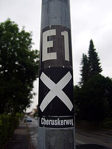
Cheruskerweg


The Cheruskerweg is a 70-kilometer long- distance hiking trail through East Westphalia-Lippe in northeast North Rhine-Westphalia . The hiking trail marked "X3" leads from Kreuzkrug, south of Detmold , to Porta Westfalica in the Minden-Lübbecke district . It is considered the eastern connecting route between the ridge path of the Teutoburg Forest , the Hermannsweg , and the ridge path of the Wiehengebirge , the Wittekindsweg . The naming refers to the Cherusci , a Germanic tribe living in the area of today's East Westphalia at the beginning of the era . Their leader Arminius was largely responsible for the battle of the Teutoburg Forest in 9 AD.
The Cheruskerweg is looked after by the Teutoburg Forest Association and local heritage associations.
location
In addition to its scenic beauty, the route connects numerous sights of Ostwestfalen-Lippe. Starting with the Hermannsdenkmal , in Detmold it passes the LWL-Freilichtmuseum Detmold (the largest farmhouse museum in Europe), the Lippe State Museum and the Princely Residence Castle in Detmold . The long-distance hiking trail runs through the former Hanseatic city of Lemgo , the birthplace of the world traveler Engelbert Kaempfer . Also directly on the way is the historic witch mayor's house , which reminds of the witch hunts that took place here in the 17th century by the inquisitor Hermann Cothmann . From Lemgo the Cheruskerweg runs through the Lippe hill country to the municipality of Kalletal . Ex-Chancellor Gerhard Schröder spent his youth in Talle , a district of the municipality . In Vlotho , the hiking trail crosses the Weser and finally joins the European long-distance hiking trail E 11 below the Kaiser Wilhelm monument .
The Cheruskerweg is marked in both directions. It mostly runs away from major traffic routes on field and forest paths through varied hill country. The hiking trail can be tackled in two to three days, depending on your fitness level and the time spent at the sights. There are overnight accommodations in all villages along the way.
literature
- Leisure map NRW No. 6 Lipper Land , scale 1:50 000, State Surveying Office North Rhine-Westphalia, ISBN 3-89439-476-5 , (is no longer published)
Web links
Coordinates: 51 ° 54 ′ 42.5 " N , 8 ° 50 ′ 29.2" E