
Beckum Mountains
| Beckum Mountains | ||
|---|---|---|
| Highest peak | Mackenberg ( 174.4 m above sea level ) | |
| location | Circles Warendorf and Soest ; Münsterland , North Rhine-Westphalia ( Germany ) | |
| part of | Kernmünsterlandes | |
| Classification according to | Handbook of the natural spatial structure of Germany | |
|
||
| Coordinates | 51 ° 45 ′ N , 8 ° 9 ′ E | |

The Beckum Mountains , named after the city of Beckum , in the North Rhine-Westphalian districts of Warendorf and Soest are up to 174.4 m above sea level. NHN high hill landscape in the Münsterland .
In addition to the Baumberge with its foothills and the Haltern Mountains , the Beckum Mountains, located in the southeast of the Kernmünsterland , are one of the few elevations in the otherwise flat, undulating Münsterland ( 55 m high) that significantly exceed their surroundings . The Werse leaves the ridge to the west at around 100 m ; in the southwest the Lippe passes at Uentrop at a good 60 m , but at some distance from the center of the elevation.
geography
location
The Beckum Mountains are located in the south-eastern part of the Münsterland, mainly in the area of the municipalities of Beckum (west), Wadersloh (south-east), Oelde (north-east) and Ennigerloh (north-west) - all in the Warendorf district . The extreme southwest is in the municipality of Lippetal ( Soest district ).
The ridge extends in the form of a horseshoe open to the west around the town of Beckum, located west of the center, with the north reaching lower altitudes than the east and south. Overall, it gently frames the Kernmünsterland , southeast of whose center it is located, and borders it craggy towards the neighborhood.
Natural allocation and structure
The Beckum Mountains are structured as follows (in the finer sub-units with two decimal places, individual localities are linked for better localization):
-
(to 54 Westphalian Bay )
-
(to 541 Kernmünsterland )
- 541.3 Beckum Mountains
- 541.30 Dolberger Heights - south
- 541.31 Stromberger Platte - East
- 541.32 Oelder Riedelland - northeast
- 541.33 Beckumer Mulde - west
- 541.34 Ennigerloher Platte - northwest
- 541.3 Beckum Mountains
-
(to 541 Kernmünsterland )
Flowing waters
Kollenbach, Lippbach and Siechenbach have their source in the Beckum Mountains, unite in the Werse and leave the mountains in a westerly direction, later turning north and flowing into the Ems . The streams flowing from the Beckum Mountains to the north ( Axtbach ) and east (e.g. Fortbach , Linzelbach , Bergeler Bach) also strive towards the Ems, while those running south ( Liese , Biesterbach, Bröggelbach) flow into the Lippe .
Surveys
The surveys of the Beckum Mountains include - sorted by height in meters (m) above mean sea level (NHN):
- Mackenberg (174.4 m), west of Sünninghausen - Stromberger Platte or eastern edge of the Beckumer Mulde
- Höxberg (162.6 m), south of Beckum , with the Soestwarte observation tower to the west of the hilltop - Dolberger Heights or the southern edge of the Beckum Mulde
- Nameless knoll (154.6 m; with Kreuzkirche), on the southern outskirts of Stromberg - Stromberger Platte
- Nameless summit (147.9 m), in Keitlinghausen (south of Oelde ) - Stromberger Platte
- Nameless summit (146.0 m), northwest of Stromberg - Stromberger Platte
- Nameless summit (143.9 m), northeast of Sünninghausen - Stromberger Platte
- Diestedder Berg (139.8 m), northwest of Diestedde - Stromberger Platte
- Önkhausberg (136.4 m), southeast of Dünninghausen - south of the Stromberger Platte
- Fackenberg (129.0 m), between Beckum and Lippborg - Dolberger Heights
- Hermannsberg (128.2 m), south of Beckum, with the KD Germanic camps and Germanic graves - Dolberger Heights
- Brunsberg (125.7 m), southwest of Beckum - Dolberger Heights
- Dalmer Berg (122.3 m), south of Beckum - Dolberger Heights
Forest areas
Some large forest areas in the Beckum Mountains are the Vellerner Brook , the Hohe Hagen near Neubeckum , the Bergeler Forest between Oelde and Stromberg and the forest areas on the Mackenberg and Diestedder Berg.
Geology and mineral resources
The Beckum Mountains represent a distinct layered landscape of Cretaceous sea deposits. Starting from the center of a depression near Beckum that is open to the west , the landscape rises gradually to the south and east, but also to the north, initially until the highest heights of the mountain group are reached . On the southern and western edge of the Beckumer Mulde , the Höxbergstufe is reached with the Höxberg ( 162.6 m ) in the south and the Mackenberg ( 174.4 m ) in the east, beyond which the landscape drops steeply. Outwardly, the somewhat but even steeper toward the edge sloping closes lower, Stromberg stage , named after Stromberg northeast of Beckum on. In the northeast of the Beckumer Berge follows the Drombergstufe , named after the Dromberg (<100 m, east of Ennigerloh - Ostenfelde ), which only about 20 m overlooks the surrounding area.
On the outwardly steeper stepped slopes there are often grazed grasslands , otherwise the natural ( climax ) vegetation alternates between red beech forest and oak-hornbeam forest . Apart from slopes and lowlands, wheat and oats are primarily grown .
In terms of mineral resources, there is primarily limestone , which is quarried to a large extent between Beckum and Ennigerloh and is used in the cement industry located there. In the past, strontianite , which was used as a whitening agent for the sugar industry, was mined here in addition to limestone .
history
South of Beckum, a little southeast of the Hermannsberg, is the large cultural monument (KD) Germanic camp, north of the mountain the small KD Germanic graves .
gallery
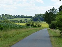
On the mountain road from Ennigerloh

Ennigerloh cement plant
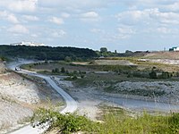
Lime pit of the Ennigerloh cement works


Individual evidence
- ↑ a b Topographical Information Management, Cologne District Government, Department GEObasis NRW ( Notes )
- ↑ E. Meynen , J. Schmithüsen : Handbook of the natural spatial structure of Germany . Federal Institute for Regional Studies, 6th delivery, Remagen 1959 (a total of 9 deliveries in 8 books 1953–1962, updated map 1: 1,000,000 with main units 1960).
- ↑ a b Geographical land survey: The natural spatial units on sheet 97 - Münster (Sofie Meisel 1960; east of the sheet) - Federal Institute for Regional Studies, Bad Godesberg → maps
- ↑ Landscape profile Beckumer Berge ( memento of the original from June 28, 2007 in the web archive archive.today ) Info: The archive link was inserted automatically and has not yet been checked. Please check the original and archive link according to the instructions and then remove this notice. of the BfN
Web links
- Natural area maps from the single sheets 1: 200,000 of the Federal Institute for Regional Studies - the Beckum Mountains are all units ending in "541.3" on sheet 97 - Münster (east of the sheet)