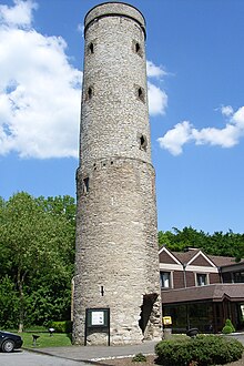
Soestwarte
The Soestwarte , formerly also Soester Warte , is a watch tower of the medieval Landwehr and today's observation tower near Beckum in the Warendorf district . It is 23.3 meters high and has a diameter of five meters at the top of the wall. The tower is located 2.5 kilometers southeast of the city center on the road to Soest (today Lippborger Strasse) on the 160 meter high Höxberg.
history
The tower as part of the Landwehr
Around 1400 an approximately 18-kilometer-long Landwehr surrounded the city and Feldmark Beckum, with 2190 hectares the largest in the Münsterland . In addition to almost two dozen barriers on the streets and paths into the surrounding area, there was also a watchtower on the roads to Hamm and Soest, the Hamm and Soest observatories. The latter is first mentioned in a document in 1464. The towers were erected in an exposed location, where the Beckum Mountains drop south into the Lippetal and allow a wide view in all directions. It was not until 1845 that it was possible to lease and two years later the purchase of sections of the Landwehr that the city's influence on the fortification ended and it was almost completely demolished.
New use and renovation
The Soestwarte was abandoned to decay earlier. The geometer Johann Jakob Vorlaender (1799–1886), who was supposed to develop a triangular network of the first order for surveying the administrative district of Münster and who saw the Soestwarte as a suitable point for connecting the Dutch and Arnberg networks, found the wall ring intact in 1824, but the interior was hollow and without the possibility of advancement. For the surveying work, it would have been enough to put a floor on the top of the tower and erect ladders inside the tower, but the residents of the town of Beckum advocated a more convenient extension so that it could also be used as a lookout tower. Therefore, the city increased the amount that the cadastral authorities had made available for the work on the tower. In which year the expansion took place is unclear.
In 1889 the tower was rebuilt and increased to 23.3 meters. A sandstone gallery was added at 11.2 meters, the original height that has now become a first floor. Battlements also adorned the top of the wall, which corresponded to the historicizing taste of the time. The gallery and battlements were removed again in 1955.
The interior painting by the Beckum painter W. Enkmann from 1958 shows Beckum motifs, including some of the Beckum attacks :
- the city watch,
- the city arms,
- "Beckumer Pütt" (in which water is to be fetched from the market fountain with a human chain, but the colonel wants to spit in his hands and lets go of the others),
- “The Beckumer Ox” (which is pulled up to the city wall with a rope around its neck so that it grazes the grass growing up there) and
- "The artificial Raths sundial" (which is provided with a roof as protection from the weather)
Individual evidence
- ↑ Die Glocke, December 9th, 2009 ( page no longer available , search in web archives ) Info: The link was automatically marked as defective. Please check the link according to the instructions and then remove this notice.
- ↑ The main triangle point "Soestwarte" on the Höxberg near Beckum in Westphalia, documentation of the Land Surveying Office of North Rhine-Westphalia, Bonn 1989, page 3 (PDF file; 14 MB)
- ↑ a b The main triangle point "Soestwarte" on the Höxberg near Beckum in Westphalia, documentation of the Land Surveying Office of North Rhine-Westphalia, Bonn 1989, p. 7 (PDF file; 14 MB)
- ↑ The main triangle point "Soestwarte" on the Höxberg near Beckum in Westphalia, documentation of the state survey office of North Rhine-Westphalia, Bonn 1989, p. 17 (PDF file; 14 MB)
- ↑ Pictures in the tower
Web links
- The Soestwarte and the Höxberg local recreation area on the website of the city of Beckum
- Landwehr Beckum with maps on the "Westphalian History" Internet portal of the Westphalia-Lippe Regional Association
Coordinates: 51 ° 44 ′ 4.2 " N , 8 ° 3 ′ 33.3" E
