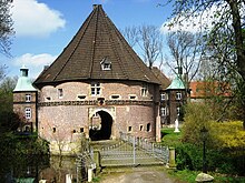
Bladenhorst
|
Bladenhorst
City of Castrop-Rauxel
Coordinates: 51 ° 34 ′ 13 ″ N , 7 ° 17 ′ 24 ″ E
|
||
|---|---|---|
| Residents : | 1141 (December 31, 2018) | |
| Incorporation : | April 1, 1926 | |
| Postal code : | 44579 | |
| Area code : | 02305 | |
|
Location of Bladenhorst in North Rhine-Westphalia |
||
Bladenhorst is a district of Castrop-Rauxel in the Recklinghausen district in North Rhine-Westphalia .
geography
Bladenhorst is the westernmost district of Castrop-Rauxel and has a rural character. After Pöppinghausen was originally a scattered settlement, a small settlement core developed in the course of the 20th century.
The district is in the north by the Rhine-Herne Canal limited and the west borders Bladenhorst to the Herne district Börnig . In the east, Bladenhorst extends to the Castrop-Rauxel main station and, with the residential area on Victorstrasse, includes part of the Castrope-Rauxel city center. The southern boundary is essentially the federal motorway 42 .
The northeast of the district is characterized by the extensive facilities of the Rütgerswerke and the conversion area of the former Victor colliery . The Castroper Holz , an old hornbeam - oak forest area, extends to the south of the district . The Deininghauser Bach and the Landwehrbach flow through Bladenhorst .
history
Bladenhorst is an old Westphalian peasantry and historically belonged to the county of Mark . The first documentary mention comes from the year 1220. Since the 19th century Bladenhorst formed a rural community in the district of Bochum in the Prussian province of Westphalia . The community initially belonged to the Herne Office and from 1897 to the Baukau Office. In 1872 the Victor 1/2 colliery was sunk in Bladenhorst and in 1897 the Rütgerswerke were founded in Bladenhorst. On April 1, 1908, the neighboring community of Pöppinghausen was incorporated into Bladenhorst, which now formed its own office. On April 1, 1926, Bladenhorst was one of the founding communities of the new town of Castrop-Rauxel.
Population development
| year | Residents | source |
|---|---|---|
| 1824 | 139 | |
| 1846 | 148 | |
| 1871 | 144 | |
| 1885 | 213 | |
| 1895 | 258 | |
| 1910 | 1453 | |
| 1925 | 1758 | |
| 1965 | 2041 | |
| 2018 | 1141 |
Architectural monuments
Under monument protection are in Bladenhorst the moated castle " Schloss Bladenhorst " the forest cemetery, the farmhouse West ring 246 and the working class neighborhood of Rutgers in the St. Mark, the Julius and Vördestraße.
traffic
The port of Victor on the Rhine-Herne Canal is used for loading coal. The Castrop-Rauxel-Bladenhorst junction of the A 42 is in Bladenhorst .
Individual evidence
- ↑ a b Population statistics Castrop-Rauxel 2018 (pdf)
- ↑ a b c d e genealogy.net: Bladenhorst
- ^ The municipalities and manor districts of the Province of Westphalia in 1871
- ^ Community encyclopedia for the province of Westphalia 1885
- ↑ 1895 census
- ↑ Uli Schubert: German municipality register 1910. Retrieved on February 2, 2017 .


