Harlinghausen (Prussian Oldendorf)
|
Harlinghausen
City of Preussisch Oldendorf
Coordinates: 52 ° 18 ′ 48 ″ N , 8 ° 29 ′ 5 ″ E
|
|
|---|---|
| Height : | 52 m above sea level NN |
| Area : | 5.52 km² |
| Residents : | 1264 (Jan. 1, 2007) |
| Population density : | 229 inhabitants / km² |
| Incorporation : | 1st January 1973 |
| Postal code : | 32361 |
| Area code : | 05742 |
|
Location of Harlinghausen in Preußisch Oldendorf
|
|
Harlinghausen is a district of Preußisch Oldendorf in the Minden-Lübbecke district in East Westphalia .
geography
Geographical location
Harlinghausen is located on the northern slope of the Wiehengebirge , the center of the natural area of the Lübbecker Loessland . Harlinghausen borders in the west on the federal state Lower Saxony , in the east on the core city Preußisch Oldendorf and the district Engershausen , in the north on the districts Getmold and Schröttinghausen , in the south on Eininghausen- Börninghausen .
The federal road 65 runs south of the core village in a west-east direction, again further south the route of the former Wittlager Kreisbahn .
The Landwehrbach runs near the western border, it flows into the Hunte just like the Heithöfer Bach. As Boden Bach coming from Wiehen, the center of the settlement from the old Saxon times is lined up next to it , earlier recognizable in particular in Courts 1 to 8 of the contribution register requested by the Great Elector Friedrich Wilhelm of Brandenburg towards the end of his reign . The Oldendorf area to the east of the Boden Bach is drained by the Great Dieck River, which reaches the Weser via the Great Aue .
From 1939 the air tank storage facility was planned and built on the northern slope of the Linke Berg with extensive railway facilities, even with a platform and the associated standard clock . The oil pipeline to the Getmold oil port on the Mittelland Canal ran along the western edge of Harlinghausen . The associated waterworks in the Masch together with the water reservoir in the forest above the LTL or simply the site enabled the rapid construction of the central urban water supply in Oldendorf after the Second World War.
At Harlinghausen's highest point, the location of the observation tower at 207 m above sea level. NN , the Wiehenturm was built with funds from the Northern Teutoburg Forest-Wiehengebirge Nature Park .
In the vicinity to the west, the road leads past into Eggetal thanks to the breakthrough of the Egge ridge in 1926 .
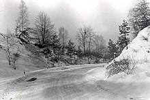
Memorial plaque :Built as an emergency work by the city of Pr. Oldendorf 1924–27 Thank God!
The mountain road leading up from the Prussian Oldendorfer town center runs, formerly - since it was built - surrounded by road trees, idyllically through a wonderful forest landscape. After a few significant inclines and skilfully inserted curves, the road finally nestles against the northern slope of the Egge and reaches the top of the pass in a final turn.
geology
With the large north-south dimension of the mash up over the crest of Wiehen addition comprising peasantry Harlinghausen a geologically rich area and reaches the Eastern Westfalia hills with Tonmergel-, lime and sandstone, the Mesozoic. It is therefore not surprising that traces of dinosaurs were found during blasting for the breakthrough through the harrow. The quarrying of natural stone for the foundation when building a house was worthwhile. To the north of the Egge down on the steep slope, several attempts to mine economical coal failed in the 19th century .
On the other hand, the Ice Age left loose rocks such as sand, gravel, loess or clay till in the transition areas to the North German Plain with abundant deposits of groundwater. The Harlinghausen settlement itself is located in the Wittlager Lößvorland, which is favorable for agricultural use and which merges into Sandlöß in the northern part.
history
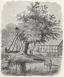
Harlinghausen was first mentioned in a document in 1242 and named as a settlement. The spelling of the place name as "Harlekeshusen" is probably derived from a personal name. A knight's seat developed in Harlinghausen from 1334 onwards, when the noble family Von dem Borne settled there after they had to cede the "Herrschaft Börninghausen " pledged by the Burgrave of Stromberg to the Counts of Ravensberg and Bruno von dem Borne had to cede a farm in Harlinghausen around 1300 had received a fief from the diocese of Minden . In 1620 Arnold von der Horst bought the estate in order to become like his father Johann von der Horst Ravensbergischer Drost in Vlotho , and in 1626 he sold it again to Goßwin von Gresten in Bielefeld , who in turn bought it in 1632 for 7000 Reichstaler to Philip Sigismund Von dem Bussche- Ippenburg sold. By the middle of the 19th century at the latest, the Harlinghausen manor became extinct when, after further changes of ownership, the estate's lands were sold or added to the Groß-Engershausen estate . The location of his house square, which had been encircled, is still recognizable by a low-lying meadow west of the main road and a little south of the village square . There is the village bell on the former syringe house , which Luise Bothe can still depict in the belfry in 1884 ; their lithography gives the impression of a thing place .
Harlinghausen has had its own cemetery since time immemorial, the Harlinghausen Leichenhof based on a plan from 1835; that is unique in the Evangelical Lutheran Parish Preussisch Oldendorf. In 1822 it was rebuilt on the southern side of the street. The village bell and memorial to the fallen soldiers of two world wars have given the former cemetery its dignity. Funeral trains from Schröttinghausen passed the Harlinghauser village bell on their long way to the Oldendorf cemetery and passed these cemeteries.
On January 1, 1973, Harlinghausen was incorporated into Preußisch Oldendorf.
Personalities
Sons and daughters
- Wilhelm Vortmeyer , farmer, entrepreneur and factory owner as well as local politician and city councilor in Preußisch Oldendorf.
Web links
- Air tank farm Preussisch Oldendorf With minor discrepancies, e.g. about the execution and intended post-war use of the enamelled steel tanks.
- Harlinghausen in the Westphalia Culture Atlas
Individual evidence
- ^ Hermann Hohmeyer, Die Bergstrasse (1928). City of Preußisch Oldendorf, city archive.
- ↑ Dieter Besserer: Manor Harlinghausen and its owners. Contributions to territorial development and aristocratic history in the area of Limberg Castle. Messages of the Mindener Geschichtsverein, year 62 (1990), pp. 35–74.
- ↑ Bürgergemeinschaft Harlinghausen (ed.): Harlinghauser history and stories. 750 years of Harlinghausen 1242-1992. Preussisch Oldendorf: Kölle Druck 1992.
- ^ Federal Statistical Office (ed.): Historical municipality directory for the Federal Republic of Germany. Name, border and key number changes in municipalities, counties and administrative districts from May 27, 1970 to December 31, 1982 . W. Kohlhammer, Stuttgart / Mainz 1983, ISBN 3-17-003263-1 , p. 325 .


