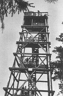
Weighing tower
The Wiehenturm is a 23.5 m high wooden observation tower south of Preußisch Oldendorf in the Wiehen Mountains . It is located north of the village of Büscherheide and around 300 meters east of the state border between Lower Saxony and North Rhine-Westphalia . The tower stands halfway between Minden and Osnabrück at 204 m above sea level. NN . Thus, its viewing platform is 227.6 m above sea level. NN .
A staircase with 103 steps leads to the platform of the tower. In 2010, an approximately 3 meter high, accessible steel structure was installed on the platform, so that it is now possible to look over the treetops, which in recent years have increasingly obstructed the unobstructed view in all directions. The weighing tower has been around 23 meters high since then.
At the moment (as of 08/2019) the weighing tower is closed due to disrepair.
Surroundings
The weighing tower, built in 1979, is near a car park and can be easily reached on foot. Next to him there is a refuge and a barbecue area . Its platform protrudes a little over the foliage in summer. One has a very nice view of the North German Plain up to 50 km away and to the Lahde power plant (38 km) near Petershagen and further in this direction - under the best conditions - to the over 60 km away, shimmering white waste dump (over 150 m above sea level) . NN ) of the potash mine south of Steinhude .
Nearby observation towers are the Wartturm (10 km east) on the Wurzelbrink ( 325 m above sea level ) and 3 km south the tower on the Nonnenstein ( 274 m above sea level ).
The forerunner of the Wiehent tower was the Dahlinghauser observation tower on the Schwarzen Brink ( 211 m above sea level ) in the Hanoverian. The wooden tower was constructed with the material available at the time, similar to the cradle tower, and stood 1.2 km west-northwest of today's car park above the opening . Under this name, the crossing of the northern foothills of the Egge between the peaks of Schwarzer Brink and Egge ( 198 m above sea level ) through the driveway to develop the western Eggetal from the north is common. A plaque commemorates the emergency work initiated by the city of Preußisch Oldendorf from 1924 to 1927. A lime kiln used to be located a little south under the Wiehenturm tower.
The Dahlinghauser tower had to be demolished after 1945 because it was dilapidated; during the Second World War it was used for an observation post to protect the former camouflage on the steep northern slope of the 157 m above sea level north of the Egge . NN leaning air tank farm LTL , s. Web links .
Use as a radio tower
Because the tower offers a good view to the north, it has been used as a radio tower for amateur radio competitions in recent years . The antennas were set up on the platform on the support pillars. The weighing tower itself has no power connection; therefore a diesel unit was used. The radio equipment (radios etc.) was in a caravan by the tower.
The weighing tower is located directly at an amateur radio relay station in the 2 m band (call sign DB0WY) on the state border. Therefore the relay had to be switched off due to the high electromagnetic field strengths during the competitions. The antennas (approx. 7 m above the platform) were also earthed ( lightning protection ).
The facility was set up for 24 hours on the first weekend in March, May, July and September by the contest group DK0LK. DK0LK is the club station of the local association N22 of the DARC . From here the longest connections, Portugal (~ 2000 km, Sporadic-E ), to Latvia (~ 1250 km, tropospheric overreach ) and Hungary (approx. 950 km without overreach) come.
DK0LK has been using the watch tower on the Wurzelbrink since 2005 .
Web links
- Amateur radio in the Wiehengebirge and the surrounding area. Local association N-22 of the German Amateur Radio Club
- Air tank farm Preussisch Oldendorf
- Air tank farm. General information about the story
Individual evidence
- ↑ The Wiehenturm ( Memento of the original from November 13, 2014 in the Internet Archive ) Info: The archive link has been inserted automatically and has not yet been checked. Please check the original and archive link according to the instructions and then remove this notice. (Status 2014 in Das Eggetal )
- ↑ Weighing tower has been raised by almost three meters. Retrieved from the Osnabrücker Zeitung on November 4, 2010
- ^ Homepage of the city of Preussischoldendorf: Wiehenturm closed , accessed on October 1, 2019
- ↑ Observation tower ( page no longer available , search in web archives ) Info: The link was automatically marked as defective. Please check the link according to the instructions and then remove this notice. on the website of Preußisch Oldendorf
Coordinates: 52 ° 17 ′ 21.5 " N , 8 ° 27 ′ 52.7" E


