Eggetal

The Eggetal is a longitudinal valley in the Wiehen Mountains, located between the former district towns of Lübbecke and Melle .
geography
The Eggetal lies in the catchment area of the Weser . By far the largest part of the valley drains over the Mühlenbach to the east into the Große Aue , a small area (around 85 ha of the valley) of the south-western Büscherheide area, however, over the Glanebach and around 10 ha of the "In der Gehle" area across the Green Lake into the Hunte .
The valley is bounded in the north by the ridge of the " Egge " with Limberg Castle , in the east by the [Große Aue], which takes the name of the Mühlenbach up to Bad Holzhausen , in the south by the Wiehen main ridge with the Rödinghauser Berg and in the West through the forest in the valley floor of the Glanebach. In the east, the valley passes into the breakthrough valley of the Great Aue at the district of Fiegenburg, the northern spacious valley floor of which is occupied by the large Crollage estate .
If the tree line is set equal to the valley border, the Eggetal has an area of approx. 700 ha. The town of Preußisch Oldendorf , thus part of North Rhine-Westphalia , includes the middle and east of the valley with the villages of Börninghausen-Masch, Börninghausen and Eininghausen; this is the largest part with around 550 ha (i.e. 78.5 percent of the area). Around 110 hectares (15.7 percent) with the high-lying village of Büscherheide at the west end of the valley belong to the city of Bad Essen and thus to Lower Saxony . The state border is roughly formed by the district roads K 79 / K 239, which run in a north-south direction. Strictly speaking, the valley is not only politically "divided in two", around 26 hectares (3 percent of the area) are in the south-west of the forest-free valley area Part of the city of Melle / district of Osnabrück / Lower Saxony and around 5 hectares (around 1/2 percent) of the “In der Gehle” area, with the Mennonite holiday home, are even part of Rödinghausen in the district of Herford / North Rhine-Westphalia. This means that the valley is "divided into three" at district level and even "divided into four" at municipal level. From the altitude, the valley extends from 70 m above sea level. NN around Gut Crollage in the east up to 215 m above sea level. NN on a field north of Büscherheide. Because of this height difference, which is comparatively large for the north-west of Germany, within the valley even strangers can sometimes perceive striking climatic and weather differences.
history
In the course of global warming after the last ice age began around 8000 BC. The gradual reforestation of the Eggetal. During this time people settled the Eggetal, as numerous Neolithic finds prove. Prehistoric man used the occurrence of dark gray pebble geodes, which he found in outcrops of the Wiehen Mountains, as raw material for stone axes. The extent to which permanent settlements existed in prehistory is not known. Settlements on a larger scale will probably only have occurred after the turn of the century around the year 600 through the advancing Saxons. It is believed that the Saxons reached the Wiehen Mountains during their expansion to the south around the year 500-600. Here they met the Angrivarians who they subjugated. Gradually, both tribes merged. The settlements in the Eggetal are therefore likely to have arisen in a planned settlement process around the year 500 - 600, when the Saxons reached the Wiehen Mountains. Taking into account the spelling of 993, the place name Börninghausen may have been derived from Born-Brunnen .
Agriculture and forestry in the Eggetal
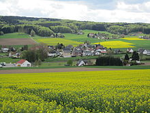
Fruit cultivation : Just a few years ago, there were extensive orchards (apple, pear), especially on the southern slopes of this sun-drenched valley, which gave the valley a flair of old country when the apple blossoms in spring . Fruit growing has a certain tradition here: As early as 1822 , the administration in Preussisch Oldendorf launched campaigns in the Eggetal to promote the cultivation of fruit trees in the form of tall trunks, which primarily involved the development of orchards near the farm. In the years 1948 / 1949 some medium-scale farmers began with the cultivation of low-standard fruit in plantation form . The cultivation area increased year by year and finally there were around 40,000 fruit trees on 25 hectares in the 1970s. Due to the generational change, this branch of business was later partly abandoned and in 1993 only 10,000 fruit trees could be counted on 7 hectares. Since then, fruit growing has continued to decline, although some plantations on the southern slope of the Limbergsattel still exist.
Forestry : The Börninghausen district, i.e. the Westphalian part of the Eggetal, has a forestry area of 234 hectares. In 1971 the forest area was owned by 127 individual farms, the sizes of which ranged from 0.09 to 23.83 hectares. The main area, about 217 hectares in size, is located on the northern slope of the Wiehengebirge, i.e. south of the Eggetal, at an altitude of 100 to 273 meters above sea level. NN. The remaining area of 17 hectares is on the Limbergsattel. This means that the majority of the forest there does not belong to the Börninghausen district, but to the adjacent districts to the north.
Attractions
At the southern border of the valley lies the Green Lake, one of the largest real mountain lakes in the Wiehen Mountains. You have a good overview of the whole valley from the platform of the Wiehenturm tower near the said national border. Not far from the border further down the valley is the Eininghausen bell .
Note: The above area data refer to the forest-free part of the area. If you include the surrounding wooded mountains up to the ridge, the valley would have an area of around 17.5 km².
Nature reserves
The 35.5 hectare Gehle nature reserve is located on the Rödinghauser side. The large forest area with partially moist valleys including numerous source streams has many valuable deciduous, mixed and coniferous forest stands. The streams that arise here and flow southwards are part of a partially protected sieve system that extends as far as the Else .
Parish
The Evangelical parish of Börninghausen encompasses the entire Eggetal, including Büscherheide. The municipality has 11.06 km² and has 1765 parishioners.
See also
Web links
- "Gehle" nature reserve in the specialist information system of the State Office for Nature, Environment and Consumer Protection in North Rhine-Westphalia
Coordinates: 52 ° 16 ′ 23.5 " N , 8 ° 28 ′ 21.8" E


