
Grüner See (Lower Saxony)
| Green lake | ||
|---|---|---|

|
||
|
The partly icy Green Lake in March 2006. Its turquoise-green color is easy to see. |
||
| Geographical location | near Buer , Wiehengebirge , Osnabrück district , Lower Saxony |
|
| Drain | Hunte in 2 km | |
| Location close to the shore | Buer | |
| Data | ||
| Coordinates | 52 ° 15 '48 " N , 8 ° 27' 16" E | |
|
||
| Altitude above sea level | 145 m | |
| surface | 0.1 ha | |
| volume | approx. 1000 m³ | |
| scope | 110 m | |
| Maximum depth | approx. 2 m | |
| Middle deep | approx. 1 m | |
|
particularities |
Artificial mountain lake |
|

|
||

The Green Lake is a lake near Melle - Buer near the Lower Saxony - North Rhine-Westphalian border. With just under 1,000 m², it is one of the largest lakes in the Wiehen Mountains east of the Hunte and one of the northernmost mountain lakes in Germany.
geography
The Green Lake is located in the district of Osnabrück and belongs to the city of Melle . It is located around 4 km northeast of Buer and around 400 m east of the Großer Kellenberg (211 m above sea level) and around 500 m west of the state border at around 145 m above sea level. NN .
Its inflow takes place on its north bank via a stream that flows into the lake via a small waterfall , the highest of the Wiehen Mountains. In the cascade, the waters plunge around 5 m into the depth.
On its southern bank, the lake is drained by a stream into the Hunte, only 2 km away . This brook has its source at a height of 240 m in the Westphalian region in Rödinghausen -Gehle. It initially flows northwards to the Eggetal , following the slope of the northern roofing of the mountains , after a little more than 600 m it changes its course at the Hunte / Große Aue - watershed and flows through a breakthrough valley into the Hunte.
History and origin of name
The Green Lake owes its existence to the fact that there was a small quarry there until the 1930s . First, from 1902, slate- like stone was extracted there for road construction and quarry stone for buildings. From 1917 to 1936 the plant was operated as a quarry for the district of Osnabrück. The mining then had to be stopped because of the excessive inflow of groundwater.
In 2003 the bottom of the lake and the bank area were extensively desludged by the Buer local history association (district of Melle ).
The name Green Lake is derived from the "turquoise-green" color of its water.
Hydrology
Assuming an average rainfall of 800 mm / year in its catchment area and an average depth of one meter, the lake has an annual inflow of about 95,000 m³ from the described brook and 800 m³ from direct input from precipitation on the lake surface. Accordingly, the lake water is exchanged around 100 times a year, or in other words, every 3 to 4 days.
Accessibility of the lake
The Green Lake is located not far to the east of Kreisstraße 203 (Kellenbergstraße) and can be easily reached on foot in five minutes from a parking lot via a signposted path. The “Markendorf-Grüner See” bus stop is not far away. There is a small refuge with seating on the west bank. Information boards provide useful information about the lake and the surrounding area. As a bathing lake, it is also rather unsuitable due to its shady location in the forest and the high water exchange and the resulting low water temperature, and there is also a lack of suitable "sunbathing areas". From the lake, an initially steep, but later, comfortable hiking trail leads to the Westphalian 274 m high Nonnenstein , on the summit of which there is an openly accessible observation tower.
Nearby, approx. 1.8 km in a north-easterly direction, at the intersection between the K 203 and the K 40 / K 79 on the southern edge of the scattered settlement of Büscherheide , a tavern offers home-style, Eggetal cuisine.
Picture gallery
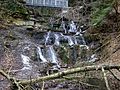
The largest waterfall in the Wiehengebirge on the Green Lake, March 2006

Waterfall, 2009

Information board at the Green Lake

Green lake with drain in the foreground, 2009


