Melle district
| coat of arms | Germany map | |
|---|---|---|

|
Coordinates: 52 ° 19 ′ N , 8 ° 22 ′ E |
|
| Basic data (as of 1972) | ||
| Existing period: | 1885-1972 | |
| State : | Lower Saxony | |
| Administrative region : | Osnabrück | |
| Administrative headquarters : | Melle | |
| Area : | 254.02 km 2 | |
| Residents: | 41,200 (Dec 31, 1971) | |
| Population density : | 162 inhabitants per km 2 | |
| License plate : | MEL | |
| Circle key : | 03 5 35 | |
| Circle structure: | 32 municipalities | |
The district of Melle was a district in the administrative district of Osnabrück from 1885 to 1972 .
Neighboring areas
At the beginning of 1972 the district bordered clockwise in the west, beginning with the districts of Osnabrück and Wittlage (both in Lower Saxony) and the districts of Lübbecke , Herford and Halle (Westphalia) (all in North Rhine-Westphalia ).
history
The district was formed in 1885 in the Prussian province of Hanover from the old Grönenberg office and the city of Melle . After 1946 the district became part of Lower Saxony . As part of the regional reform in Lower Saxony , it was incorporated into the Osnabrück district on July 1, 1972 . All municipalities in the district were united in the city of Melle.
Population development
|
|
District administrators
- 1872–1889 Conrad Hermann Albrecht von Wehrs
- 1889–1919 Otto von Pestel (1848–1919)
- 1919–1928 Ludwig von Bar (1886–1928)
- 1928–1934 Karl Gossel (1892–1966)
- 1934–1935 Karl Glehn
- 1935–1943 Hermann von der Forst
- 1943–1945 Gustav Lemke
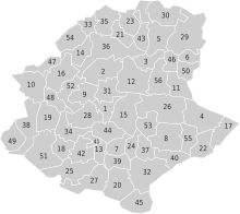
Communities
The municipalities of the district of Melle with the number of inhabitants on June 6, 1961:
|
|
|
1 Bruchmühlen has also been in use for Bennien and Düingdorf since 1322
2 The community Eicken-Bruche was created in 1929 through the merger of the two communities Eicken, parish Buer and Eicken, parish Melle .
3 formerly also called: Handarpe, parish Wellingholzhausen
4 formerly also called: Schlochtern, parish Sondermühlen
5 formerly also called: Schlochtern, parish Wellingholzhausen
6 formerly also called: Handarpe, parish Sondermühlen
The above structure lasted until 1970. The regional reform in Lower Saxony was carried out in two steps in the Melle district. First, on January 1, 1970, a series of incorporations took place:
- The municipalities of Altenmelle, Bakum, Dielingdorf, Drantum, Eicken-Bruche, Eickholt, Gerden, Handarpe, Sondermühlen, Laer and Niederschlochtern were incorporated into the city of Melle.
- The communities of Handarpe, Himmern, Kerßenbrock, Nüven, Peingdorf, Oberschlochtern, Uhlenberg and Vessendorf were incorporated into the community of Wellingholzhausen.
- The communities Bennien, Döhren, Groß Aschen, Hoyel, Krukum, Westendorf and Westhoyel were merged to form the new community Riemsloh .
The remaining 29 municipalities were in four joint communities listed. From 1970 to 1972 the district of Melle was divided into the following 32 municipalities:
In 1972 the district was dissolved, all municipalities were combined to form the city of Melle and this was assigned to the Osnabrück district .
License Plate
On July 1, 1956, the district was assigned the distinctive sign MEL when the vehicle registration number that is still valid today was introduced . It was issued until October 11, 1972. Due to the license plate liberalization , it has been available in the Osnabrück district since June 11, 2018 .
Web links
- City of Melle
- City of Melle: Land use plan reorganized 2004. Explanatory report (municipal structure in the Melle district, see Chapter 4) (PDF; 6.8 MB)
Individual evidence
- ^ Federal Statistical Office (ed.): Historical municipality directory for the Federal Republic of Germany. Name, border and key number changes in municipalities, counties and administrative districts from May 27, 1970 to December 31, 1982 . W. Kohlhammer, Stuttgart / Mainz 1983, ISBN 3-17-003263-1 , p. 256 f .
- ↑ Statistical Yearbook for the Federal Republic of Germany 1973
- ↑ Uli Schubert: German municipality register 1910. Retrieved on March 29, 2013 .
- ^ Community encyclopedia for the Free State of Prussia: Province of Hanover Verlag des Prussian State Statistical Office, 1930
- ↑ Law on the expansion of the city of Melle of 25 November 1969
- ^ Law on the reorganization of the community of Wellingholzhausen of November 25, 1969
- ↑ Law on the formation of the Riemsloh community of July 8, 1969
- ↑ Law on the reorganization of the municipalities in the Osnabrück area of May 10, 1972


