
District of Braunschweig
| coat of arms | Germany map | |
|---|---|---|

|
Coordinates: 52 ° 16 ' N , 10 ° 31' E |
|
| Basic data (as of 1974) | ||
| Existing period: | 1833-1974 | |
| State : | Lower Saxony | |
| Administrative region : | Braunschweig | |
| Administrative headquarters : | Braunschweig | |
| Area : | 409.74 km 2 | |
| Residents: | 96,800 (Dec. 31, 1973) | |
| Population density : | 236 inhabitants per km 2 | |
| License plate : | BS | |
| Circle key : | 03 7 32 | |
| Circle structure: | 66 parishes | |
| Address of the district administration: |
Eiermarkt 4–5 3300 Braunschweig |
|
| District Administrator : | Fritz Lau | |

The district of Braunschweig was a district in Lower Saxony until 1974 . It was last 409.74 km² and had 96,800 inhabitants. In the 1960s it was only 48th among the then sixty districts of Lower Saxony in terms of area, but eighth place in terms of population.
geography
Neighboring areas
At the beginning of 1974 the district bordered in a clockwise direction in the west, beginning with the districts of Peine , Gifhorn , Helmstedt and Wolfenbüttel and the independent city of Salzgitter . The city of Braunschweig, which has been an independent city since 1925, was enclosed by the area of the district.
Thedinghausen exclave
For historical reasons (belonging to the Duchy or Free State of Braunschweig as an exclave), part of the Braunschweig district was about 150 km from Braunschweig in the north-west: the area around Thedinghausen and Emtinghausen on the Weser between Bremen and Verden , then with almost 5,000 inhabitants approx. 63 km². District council meetings were held here regularly in what was then the Hotel Braunschweiger Hof . Thedinghausen and Emtinghausen have belonged to the Verden district since July 1, 1972 . The coat of arms of the municipality of Thedinghausen and the integrated municipality of Thedinghausen is based on that of the former district of Braunschweig to this day. The main road in Thedinghausen still bears the name Braunschweiger Straße after the former state capital and district town.
history
The circle was created in 1833 when the Duchy of Braunschweig was divided into six circles.
In 1850 the district area was expanded by adding the “ Thedinghausen Office, both in relation to the administration of justice and to the administration of the Braunschweig district”, which had previously belonged to the Holzminden district (see history of the Holzminden district ) .
With the entry into force of the recast city order of the State of Braunschweig , the city eliminated Brunswick on April 1, 1925 out of the circle. In 1931, the district of Braunschweig gave the municipality of Veltenhof and on April 1, 1934 the municipalities of Gliesmarode , Lehndorf , Melverode , Ölper , Querum , Riddagshausen and Rühme to the independent city of Braunschweig. In 1941, as part of the reorganization of the national borders of Braunschweig and Prussia, the communities of Ölsburg and Neuölsburg were reclassified from the Braunschweig district to the Peine district in what was then Prussia as part of the so-called Salzgitter Act . At the same time, the municipality of Woltorf , which had previously belonged to the district, was incorporated into the Prussian municipality of the same name in the district of Peine.
On July 1, 1968, the communities of Wendeburg , Wendezelle and Zweidorf merged to form a new community of Wendeburg . Two years before the final dissolution of the Braunschweig district was the last change in its territorial status: The Thedinghausen district, which had been part of it for 122 years, was spun off on July 1, 1972 and assigned to the Verden district. The municipality Essenrode was in the newly formed unified community on the same day teaching incorporated and thus came to Brunswick County. While the municipalities of the Thedinghausen office were assigned to the Verden district, Essenrode was previously a municipality in the Gifhorn district . At the time of its spin-off, the Thedinghausen office consisted of the member communities Ahsen-Oetzen , Dibbersen-Donnerstedt (with the localities Dibbersen and Donnerstedt ), Eißel , Holtorf-Lunsen (with the localities Holtorf and Lunsen ), Horstedt, since January 1, 1966 , Thedinghausen and Werder existing joint community Thedinghausen and the communities Bahlum and Emtinghausen .
On March 1, 1974, the Braunschweig district was dissolved. The city of Braunschweig - previously the administrative seat of the Kragenkreis - became the district's legal successor. At that time still belonged to the area of the district
- the 66 communities Abbenrode , Alvesse , Beienrode , Bettmar , Bevenrode , Bienrode , Bodenstedt , Bortfeld , Broitzem , Cremlingen , Denstorf , Destedt , Dibbesdorf , Duttenstedt , Erkerode , Essehof , Essinghausen , Flechtorf , Fürstenau , Gardessen , Groß Brunsrode , Groß Gleidingen , Harvesse , Hemkenrode , Hötzum , Hondelage , Hordorf , Klein Brunsrode , Klein Gleidingen , Klein Schoeppenstedt , Köchingen , lamb , teaching, Liedingen , Lucklum , Mascherode , Meerdorf , Neubrückenstraße , Niedersickte , Obersickte , Rautheim , Rüningen , Schandelah , Schapenberg , Schulenrode , Sierße , Sonnenberg , Sophiental , Stöckheim near Braunschweig , Thune , Timmerlah , Vallstedt , Vechelade , Vechelde , Veltheim , Völkenrode , Volkmarode , Waggum , Wahle , Watenbüttel , Weddel , Wedtlenstedt , Wendeburg , Wenden , Wendhausen and Wierthe as well
- the municipality-free areas Beienrode, Buchhorst, Essehof I, Essehof II, Essehof III, Meerdorfer Holz, Querum, Sophiental I, Sophiental II and Wendhausen.
The localities of the dissolved district were incorporated into the city of Braunschweig or incorporated into the districts of Helmstedt, Peine and Wolfenbüttel as follows.
( Map with all linked pages: OSM | WikiMap )
![]()
|
|
|
|
|
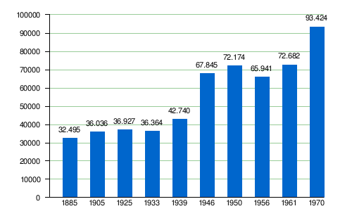
Population development
Population numbers according to the respective area
The district was significantly reduced in size in 1925 when the city of Braunschweig left.
| year | Residents | source | Timeline |
|---|---|---|---|
| 1890 | 141,632 |

|
|
| 1900 | 171,813 | ||
| 1910 | 191.112 | ||
| Outsourcing of the city of Braunschweig | |||
| 1925 | 49.176 | ||
| 1933 | 48,891 | ||
| 1939 | 43,799 | ||
| 1950 | 72.182 | ||
| 1960 | 69,900 | ||
| 1970 | 93,400 | ||
| 1973 | 96,800 | ||
Population figures according to the area in 1970
|
footnote
(1) 1905: There are different population data for this year.
politics
In the 28 years from 1946 to the dissolution of the Braunschweig district in 1974, eleven district administrators (including one in two different periods) and two senior district directors held office .
District administrators
| Term of office from |
Term of office until |
Surname | comment |
|---|---|---|---|
| 1851 | Carl von Hohnhorst | ||
| 1857 | Adrian Bernhard August Orth | ||
| 1886 | Eduard Orth | ||
| 1895 | Conrad Langerfeldt | ||
| 1913 | Robert Boden (District Director), Blankenburg | ||
| 1914 | Paul Rini (District Director), Helmstedt | ||
| 1923 | Henri Erdmann | ||
| 1931 | Johannes Lieff | ||
| 1931 | Wilhelm Kybitz | ||
| 1936 | Gustav Arendts | provisional | |
| 1938 | 1945 | Friedrich Bergmann , Blankenburg | |
| Jan. 1946 | Nov 1946 | Friedrich Brandes , Wendhausen | |
| Nov 1946 | Dec 1947 | Richard Keye , Rüningen | |
| Dec 1947 | Nov. 1948 | Emil Karcher , Essinghausen | |
| Dec 1948 | Dec 1951 | Wilhelm Fick , Wenden | |
| Dec 1951 | March 1952 | Hans Heldt ( FDP ), Vechelde | |
| June 1952 | Dec 1952 | Hans Heldt (FDP), Vechelde | |
| Dec 1952 | Dec 1954 | Martin Elsner ( GB / BHE ), Volkmarode | |
| Dec 1954 | Nov 1956 | Robert Kugelberg ( SPD ), Stöckheim | |
| Nov 1956 | Apr. 1961 | Richard Lippe , Wendeburg | |
| Apr. 1961 | June 1963 | Wilhelm Schlueter (SPD), Stöckheim | |
| June 1963 | Oct 1964 | Martin Elsner, national marauder | |
| Oct 1964 | Nov 1972 | Carl Lauenstein ( CDU ), Bodenstedt | |
| Nov 1972 | Feb 1974 | Fritz Lau , Stöckheim | officiated until the district was dissolved |
Upper District Directors
- October 1946 to January 1965 Helmut Meyer , Braunschweig
- February 1965 until the Walter Geffers district , Braunschweig, was dissolved
License Plate
On July 1, 1956, the district (and thus also the Thedinghausen exclave) was assigned the distinctive sign BS when the license plates that are still valid today were introduced . In the independent city of Braunschweig it is still issued today.
literature
- Edeltraut Hundertmark (arr.): The district of Braunschweig. Braunschweig administrative district . In: Die Landkreise in Niedersachsen , Volume 22, I. Official district description, II. Official district description. Appendix, Walter Dorn Verlag, Bremen-Horn 1965
Web links
- Heinrich Heidersberger : District Office. Dataset 83005634. In: Deutsche Fotothek . Saxon State Library - Dresden State and University Library , 1959, accessed on December 6, 2011 (photo of the former district building on the Eiermarkt in Braunschweig).
Individual evidence
- ↑ a b Walter Geffers: Farewell to the district Braunschweig . In: Landkreis Braunschweig (Ed.): Heimatbote des Landkreis Braunschweig 1974 . Oeding, Braunschweig 1974, p. 20-26 .
- ↑ a b illustration on www. territorial.de , accessed on April 25, 2012
- ↑ Ordinance on territorial adjustments in the area of the Hermann-Göring-Werke Salzgitter. From June 25, 1941 , Reichsgesetzblatt I, p. 357.
- ↑ a b Federal Statistical Office (ed.): Historical municipality register for the Federal Republic of Germany. Name, border and key number changes in municipalities, counties and administrative districts from May 27, 1970 to December 31, 1982 . W. Kohlhammer, Stuttgart / Mainz 1983, ISBN 3-17-003263-1 , p. 266 ff .
- ^ The communities in the Braunschweig district . In: Landkreis Braunschweig (Hrsg.): Heimatbote des Landkreis Braunschweig 1972 . Oeding, Braunschweig 1972, p. 162–167 (information on the Thedinghausen office on p. 166, information on the Thedinghausen municipality on p. 167).
- ^ The localities in the Braunschweig district . In: Landkreis Braunschweig (Ed.): Heimatbote des Landkreis Braunschweig 1968 . Oeding, Braunschweig 1968, p. 170-173 .
- ↑ a b c d e f g h Michael Rademacher: German administrative history from the unification of the empire in 1871 to the reunification in 1990. braunschweig.html. (Online material for the dissertation, Osnabrück 2006).
- ↑ Statistical Yearbook for the Federal Republic of Germany 1972
- ↑ Statistical Yearbook for the Federal Republic of Germany 1975
- ↑ Gustav Uelschen: The population in Lower Saxony from 1821 to 1961 . In contradiction to this, the population of 49,602 is given for the year 1905 at www.territorial.de Landkreis Braunschweig .
- ^ District administrators and senior district directors from 1946 . In: Landkreis Braunschweig (Ed.): Heimatbote des Landkreis Braunschweig 1974 . Oeding, Braunschweig 1974, p. 27 .

1972 dissolved: District of Bersenbrück | District of Blankenburg | District of Melle | Wittlage district | Zellerfeld district
1973 dissolved: District of Duderstadt | Münden district
1974 dissolved: District of Braunschweig | District of Burgdorf | District of Einbeck | District of Hildesheim-Marienburg | District Neustadt am Rübenberge | Springe district
1977 dissolved: District of Alfeld (Leine) | Aschendorf-Hümmling district | District of Bremervörde | Fallingbostel district | District of Gandersheim | County of Diepholz County | County Hoya county | County of Schaumburg | District of Hadeln | District of Lingen | District of Meppen | North County | Rotenburg (Wümme) district | District of Schaumburg-Lippe | District of Soltau | District of Wesermünde
2001 dissolved: District of Hanover
Disbanded in 2016: District of Osterode am Harz