
Egg market (Braunschweig)
| Egg market | |
|---|---|
|
|
|
 |
|
| Eiermarkt, view to the south | |
| Basic data | |
| place | Braunschweig |
| District | Old town |
| Created | in the middle ages |
| Hist. Names | Steynmarkt |
| Connecting roads |
At the Martinikirche food stall Petersilienstraße Steinstraße |
| Cross streets | (formerly) Jacobstrasse |
| Buildings | Jakobskirche , Jakob-Kemenate , landscape house |
| use | |
| User groups | Pedestrian traffic , bicycle traffic , car traffic |
| Road design | Cobblestones |
| Technical specifications | |
| Street length | 100 m |
The Eiermarkt is a street in Braunschweig . It is one of the oldest part precincts of Old Town .
history
.png)
.JPG&filetimestamp=20121028094527&)
The area around the egg market is one of the first urban centers in Braunschweig. On an elevation in the swampy area of an Oker crossing , a rest area was created, later a place of residence for the merchants. The Eiermarkt was presumably located near old military and trade routes that ran through the city, such as Breite Straße , Hutfilter , Kaiserstraße , Reichsstraße and the Kohlmarkt . The oldest surviving building on the street and probably the oldest church in Braunschweig is the Jakobskirche . Next to it is a created in 1250 Kemenate that the oldest preserved secular buildings owned by the city. The property on the corner of Eiermarkt and Petersilienstraße belonged to the St. Jakobi parish for a long time; as early as 1346, the house there was known as sunte Jacoppes wedeme ("parish of Saint Jacob"). It was later used as the second preacher's house for the Saint Martini congregation.
A historical map describing around the year 1400 shows the Steynmarkt, an almost square square , in the south of today's Eiermarkt . According to other investigations, there was no space there. The name "Eiermarkt" was first mentioned in 1479. Up to this point the area was added to the stone market. Presumably rural products were sold there. Opposite was the “Ratsapotheke” on the corner of the street Garküche , which has been in use since 1476 and was later also known as the “Large Pharmacy” or “Martini Pharmacy”. A map from 1755 shows the Eyer Marckt or the Eier Marckt as an L-shaped street, the second section occupying the position of today's Steinstraße. In 1765 the "Ducal Leihhausanstalt" was set up in the house at Jacobstrasse 3 and is considered the first German bank. Part of this building was the bower, which today belongs to the egg market. In 1765, a rococo- style house was built on the southeast corner . It was a two-story half-timbered building, the entrance of which was in the rounded south-west corner at the south end of the Eiermarkt. It was used as a pawnshop and later, until its destruction in World War II, as the administrative seat of what was then the Braunschweig district. On the north-west corner, the late Baroque - early Classicist " Landscape House " was built by Christian Gottlob Langwagen from 1793 to 1798 .
Almost all buildings on the Eiermarkt were destroyed by bombing during the Second World War. The area then lay fallow for a long time; only archaeological investigations were carried out. Even after the Second World War, the northern part of Eiermarkt 1 was still home to the “Martini Pharmacy” and the Graff bookshop in the southern part until 1958 . In the 1950s, a new building was erected in place of the destroyed district administration building, which took over administration until the district was dissolved in the early 1970s. Today the city of Braunschweig uses it as an administrative building. In some cases, reconstruction did not begin until the 1970s to 1990s.
The landscape house was rebuilt in a somewhat simplified form from 1990. Since then, most of the west side of the egg market has been taken up by a new building. Together with a former town house immediately south of the landscape house, the complex of landscape house and new building has since served as the district court of the city and the communities of Vechelde and Wendeburg . During the reconstruction, special emphasis was placed on maintaining the historic street location, the visual relationships and the number of floors. The western part of the former Jacobstrasse, which led to the Kohlmarkt, was only set up as an entrance to the " Jakob-Kemenate ". A synthesis of historical and avant-garde architectural motifs was chosen for their reconstruction. The Jakob-Kemenate was inaugurated in 2006.
Plant and traffic
The Eiermarkt runs roughly from north to south, with a slight bend in the northern section. It is mainly used for local traffic and is not greened. At the southern end there is a small extension of the street space towards Steinstraße. By cobblestones and lanterns in the style of the 19th century the street was given back some of their earlier Gepräges. There are sidewalks on both sides of the street. To the north is the An der Martinikirche square, which is sometimes referred to as the “egg market”. At the southern end, the egg market continues in the offset street Alte beinhauerstraße .
Buildings
| Egg market | |
|---|---|
The egg market on a map of the city of Braunschweig from 1899
|

.jpg)

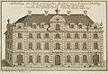
The council pharmacy (representation from 1717)
Martini pharmacy (engraving from 1778)

Jakobskirche
(representation from 1711)
Pawnshop at the corner of Eiermarkt and Steinstrasse (1892)


- Egg market 1
- The four-storey, plastered and white-painted house on the corner of the cookshop is used for residential purposes and practices.
- Egg market 1A
- The jakob-kemenate, which opened in 2006, serves cultural purposes, such as art exhibitions.
- Egg market 2
- The sandstone west wall of the towerless Jakobskirche borders the Eiermarkt. It is used as the community room of the Protestant parish of St. Martini .
- Egg market 3
- The Sankt Martini community office is located in Eiermarkt 3. The house with its modern structured facade sets itself apart from historical architectural styles.
- Egg market 4–5
- The house on the corner of Eiermarkt and Steinstrasse is a complex of a modern building with a coffin roof in Eiermarkt and a house with a hipped roof on Steinstrasse . This is where the Department of Children, Youth and Family of the City of Braunschweig is located with the Office for Education Funding.
- At the Martinikirche 8
- The entrance to the district court is in the new landscaped house. Only the portico at the An der Martinikirche is from the previous building. A former town house, which also belongs to the district court, is located in the south of the Eiermarkt. It was also rebuilt after the war.
- The east facade of the new district court building takes up a large part of the egg market. In the south it borders on Petersilienstraße, in the west on tournament street . The facade is structured with regularly recurring windows and sandstone pilaster strips ; the top is an implied tiled roof with dormers . There is an underground car park in the basement.
- Egg market 8
- The former town house is the only house on the west side that does not belong to the district court. It serves as a residential building.

The Jakobskirche

The Jakob-Kemenate, on the far left the Jakobskirche
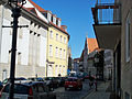
Looking north, on the left the facade of the new district court building


.JPG&filetimestamp=20121028094527)
Others
The “multi-storey car park Eiermarkt” is located west of the Eiermarkt between Güldenstrasse , Heydenstrasse , Tournamentstrasse and Petersilienstrasse.
literature
.JPG)
- Johannes Angel: egg market. In: Luitgard Camerer, Manfred Garzmann, Wolf-Dieter Schuegraf, Norman-Mathias Pingel (eds.): Braunschweiger Stadtlexikon. Meyer, Braunschweig 1992, ISBN 3-926701-14-5 , p. 65.
- Jürgen Hodemacher : Braunschweig's streets - their names and their stories. Volume 1: Inner City. Elm-Verlag, Cremlingen 1995, ISBN 3-927060-11-9 .
- Wolfgang Kimpflinger: Monument topography Federal Republic of Germany , architectural monuments in Lower Saxony, Volume 1.1 .: City of Braunschweig, Part 1. Hameln 1993, ISBN 3-87585-252-4 , pp. 85-86.
- Heinrich Meier : The street names of the city of Braunschweig. In: Sources and research on Brunswick history. Volume 1, Wolfenbüttel 1904, pp. 38-39, ( digitized version ).
- Paul Jonas Meier , Karl Steinacker : The architectural and art monuments of the city of Braunschweig. 2nd, expanded edition, Braunschweig 1926.
Web links
- The egg market at braunschweig.de
Individual evidence
- ↑ a b c d Meier: The street names of the city of Braunschweig. P. 39.
- ↑ The egg market at braunschweig.de, accessed on October 23, 2012.
- ↑ Kimpflinger: Monument topography of the Federal Republic of Germany, architectural monuments in Lower Saxony, Volume 1.1 .: City of Braunschweig, part 1. p. 86.
- ^ Meier: The street names of the city of Braunschweig. P. 38.
- ↑ a b Luitgard Camerer, Manfred Garzmann, Wolf-Dieter Schuegraf, Norman-Mathias Pingel (ed.): Braunschweiger Stadtlexikon. Meyer, Braunschweig 1992, ISBN 3-926701-14-5 , p. 65.
- ↑ Jakob-Kemenate at braunschweig.de, accessed on October 23, 2012.
- ^ Elmar Arnhold, Sándor Kotyrba: Cityscape in Transition - Braunschweig - Volume II. Kotyrba Verlag, Braunschweig 2012, ISBN 978-3-942712-23-1 , pp. 42–43
- ^ Hermann Bollmann: Braunschweig rubble plan. Bollmann-Bildkarten-Verlag, Braunschweig.
Coordinates: 52 ° 15 ′ 42 ″ N , 10 ° 31 ′ 2 ″ E