Mascherode
|
Mascherode
City of Braunschweig
|
|
|---|---|
| Coordinates: 52 ° 13 '24 " N , 10 ° 33' 58" E | |
| Height : | 84 m above sea level NN |
| Residents : | 3827 (Dec. 31, 2017) |
| Incorporation : | March 1, 1974 |
| Postal code : | 38126 |
| Area code : | 0531 |
|
Mascherode in Braunschweig
|
|
|
Village church
|
|
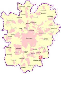
Mascherode is a southern district of Braunschweig . It is located in District 213 - Südstadt-Rautheim-Mascherode .
Surname
The name Mascherode is made up of Masch for wet alluvial land and clearing and means "clearing in wetland". The place is still surrounded by forest on three sides and has a high water table in the old village center. The East Westphalian dialect is "Maschero (e)". Sometimes you hear "Matschedero" as a joke. In the 17th and 18th centuries, the Latinized forms Masqueroda or Masquerode were often used in documents .
It used to be mistakenly assumed that Mascherode was the old Marquarderode. Today, however, we know that this Marquarderode, which became desolate at an early age , was located in the area of today's Siegfriedviertel , where the Ärkeröder field was still shown on old maps in the 18th century .
history
The villages with the ending -rode are assigned to the second clearing period from 1000 AD. While the neighboring towns of Salzdahlum and Sickte 888, Stöckheim and Melverode 1007 and Rautheim 1031 are mentioned, Mascherode does not appear in the deed of the Halberstadt Monastery until 1192 . The Riddagshausen Abbey then exchanged by the Cathedral Chapter Halberstadt two hooves in Marsceroth one.
The Riddagshausen monastery gradually managed to take possession of the entire village: in 1204 it acquired six more Hufen in Marsekerod and the Kohliholz from King Otto IV, and these acquisitions in villa Mascherode in 1208 were confirmed by the Bishop of Halberstadt. In 1219 he left the church with the bailiwick in Marsceroth to the Cistercian monastery , and Count Palatine Heinrich probably gave the church patronage in the same year .
After the monks had acquired the whole village, they set up an estate, a so-called grangie , on which a “magister” Dietrich is attested in Marscheroth as early as 1248 , to work from their own hands in addition to the daily prayers of the hour to live. These Grangien soon suffered from a lack of offspring, so that the duke allowed the monastery in 1335 to resettle farmers in Mascherode.
After the re-establishment, Mascherode belonged entirely to the Riddagshausen monastery. The convent, and at its head the abbot, was the landlord of all courts, drew the tithe and exercised the lower jurisdiction . In addition, the monks continued to look after the village ecclesiastically for centuries, because Mascherode was raised to the parish seat only after the Reformation in 1576.
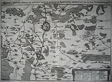
In its long history, Mascherode was repeatedly drawn into the fighting between the Duke of Braunschweig-Wolfenbüttel and the free Hanseatic city of Braunschweig and therefore repeatedly robbed, looted and destroyed by both sides; It was particularly bad in 1492, during the turmoil of the Reformation from 1542 to 1553, 1602, 1605, 1615 and the Thirty Years' War . When the dukes were finally able to besiege and conquer the city of Braunschweig successfully in 1671 , they pitched their army camp in the Riddagshausen monastery villages, at that time over 20 wounded soldiers died in Mascherode alone.
The dependence on the monastery did not end until the 19th century. After the dissolution of the Riddagshausen monastery court, Mascherode came to the eastern canton of Wolfenbüttel in the Westphalian era in 1807 and became part of the newly formed Riddagshausen district court in 1814, from which the Braunschweig district later emerged.
In the 1830s and 1840s, the land taxes , hand and tension services and the tithe to the monastery were replaced and the farmers became owners of their farms. The separation carried out from 1847 to 1853 and radical changes in agriculture such as the abolition of three-field farming , the introduction of artificial fertilizers and the cultivation of sugar beet led to the prosperity of the farmers.
In the middle of the 19th century, the limestone lying south of the village gained economic importance. The farmers Bötel and Friese were the first to mine the limestone, at the end of the 19th century Conrad Mesecke built a lime works and finally in 1903 a large lime works was built by Rudolph Bannow. The factory brought new life to the village; seasonal workers were employed from all over Central Europe. The work came to a standstill in the 1920s with the global economic crisis and could only be continued temporarily until the 1950s. Another large employer in the early 20th century was the Vosssche Gutsverwaltung. Many Poles came to Mascherode at this time, some stayed permanently.
Despite this relative upswing, Mascherode remained dominated by agriculture, even though the number of craftsmen and commuters to Braunschweig increased. A turning point was the end of the Second World War . Now numerous refugees and displaced persons from the former German eastern regions came to Mascherode, which almost doubled the population. Many of the newcomers settled on the southern edge of the village in the 1950s.
From the 1960s onwards, another increase in population began with people moving from Braunschweig who built houses in Mascherode. At the same time, agriculture began to decline.
During this time, the independent community developed into the preferred residential area of the then district and the independent city of Braunschweig. Numerous projects decided by the municipal council and the administration supported the attractiveness and growth of the place, so that the number of inhabitants more than doubled by the time it was incorporated, while still preserving tradition and history.
Investments in the area-wide sewer system in the historic town center as well as in the development of large new residential areas were implemented. A separate sewage treatment plant was built, public transport and school bus connections were implemented, a kindergarten was built, the cemetery and the funeral chapel were expanded, the parish building and parish hall for social events were renovated, a new fire station and a sports hall were built. Tennis courts and a riding facility were a popular leisure center. Doctors and a pharmacy provided health care for the residents.
The plans to expand a small central shopping center for better local supplies for the community could no longer be realized due to the incorporation.
In 1974 the place came to the city of Braunschweig as part of the administrative reform, after parts of the Feldmark had already been incorporated in 1934 for the construction of the "Siedlung Mascherode" (since 1955 Braunschweiger Südstadt ).
From 1960 to 1974 (until it was incorporated into the city of Braunschweig), Werner Rost was the full-time municipal director.
geography
Mascherode lies at a height of 84 m in the glacial valley of the Oker , south-southeast of the Braunschweig city center. Except for the southwest, the place is completely enclosed by forest. The southern edge of Mascherode bordered the Braunschweiger Landwehr archeological cultural monument in the 15th century . The Spring , a spring pond that flows into the Oker, rises in the area of the village . The Heidbergsee recreation area borders directly on Mascherode .
administration
Mascherode has been part of the Südstadt-Rautheim-Mascherode district since 1974 . District Mayor is Jürgen Meeske ( SPD ), Deputy Achim Weitner-von Pein ( GREEN ).
coat of arms
Blazon : “Divided by silver over red; above a red lion head, below a silver tree stump. ”The colors of the coat of arms correspond to those of the city of Braunschweig.
The coat of arms shows a red lion head on a white background in the upper half and a white tree trunk in the lower half. The lion symbolizes that the place belongs to the city of Braunschweig. The tree trunk stands of course for the clearing activity of the Masch in the swamp area, which preceded the settlement.
The coat of arms was designed by the heraldist Philipp Schmidt and adopted on March 8, 1979 by the Mascherode local council.
societies
- In 1906 the “Pig Insurance Interest in Mascherode” was founded as a neighborhood aid organization. The General Assembly decided on April 27, 1980 to dissolve the pig fund .
- 1919 Founding of the sports club TV Mascherode as a local sports club. This celebrated its 100th anniversary in 2019 on the forest sports field in Mascherode.
Attractions
- The Friedenseiche natural monument was planted by Sedan in 1873 on the occasion of the German victory peace .
- The old cloister courtyard from the 13th century with a historicist cowshed from the 19th century.
- The village church from the 12th century. With about Martin Luther's 400th birthday planted Luther Linde from 1883.
- Archaeological cultural monument Braunschweiger Landwehr in the southwest of Mascherode.
- The Mascheroder Holz has been a landscape protection area since 1969 and has been part of the Mascheroder- and Rautheimer Holz nature reserve since 2019 .
literature
- G. Count of Bocholtz-Asseburg: Asseburg document book. Part 1, Hanover 1876.
- Fritz Habekost: Chronicle of Mascherode. Braunschweig 1982.
- Henning Habekost, Jürgen Kuck: The mural from Mascherode. Braunschweigische Landschaft e. V. 2007.
- Hermann Kleinau : Geschichtliches Ortverzeichnis des Landes Braunschweig L – Z , In: Publications of the historical commission for Lower Saxony (Bremen and the former states Hanover, Oldenburg, Braunschweig and Schaumburg-Lippe) , XXX, Geschichtliches Ortverzeichnis von Niedersachsen , 2, Land Braunschweig August Lax Publishing bookstore, Hildesheim 1968
- T. Schmidt: Document book of the Halberstadt Monastery and its bishops. Part 1, Leipzig 1883.
- Helmut Weihsmann : Building under the swastika. Architecture of doom. Promedia Druck- und Verlagsgesellschaft mbH, Vienna 1998, ISBN 3-85371-113-8 , pp. 315-316.
Web links
- Mascherode on the official homepage of the city of Braunschweig at braunschweig.de
- Family book by Mascherode from 1542
- Mascherode's private website (is no longer managed)
- Chronicle of the southern city
Individual evidence
- ↑ Population statistics on braunschweig.de, accessed on July 29, 2018
- ↑ When creating the parish registers, Pastor Wiegmann noted in 1652 parochia Mascherodana, verius Marquarderodana (= Parish Mascherode, actually Marquarderode) and Hassel and Bege wrote Mascherode in 1802 , in old times Markwarderode (G. Hassel and K. Bege: Geographisch = statistical description of the Principality of Wolfenbüttel and Blankenburg, Volume 1, Braunschweig 1802, page 361).
- ^ Historical index of the state of Braunschweig. P. 396.
- ^ Document book of the Halberstadt Monastery I 335
- ↑ Asseburg Document Book I 32
- ^ Document book of the Halberstadt Monastery I 445
- ^ Lower Saxony State Archive Wolfenbüttel, signature 24 Urk 44
- ↑ Lower Saxony State Archives Wolfenbüttel, signature 24 Urk 45
- ^ Lower Saxony State Archives Wolfenbüttel, signature 24 Urk 92
- ↑ Lower Saxony State Archives Wolfenbüttel, signature 24 Urk 642
- ↑ Inheritance register of the Riddagshausen monastery from 1605 (Lower Saxony State Archives Wolfenbüttel, call number 19 Alt 155)
- ↑ certificate of appointment of the Reverend Johan Paseker in Landeskirchlichen Archives in Wolfenbüttel
- ^ Arnold Rabbow: New Braunschweigisches Wappenbuch. Braunschweiger Zeitungsverlag, Meyer Verlag, Braunschweig 2003, ISBN 3-926701-59-5 , p. 17.
- ↑ Forests and small bodies of water between Mascherode and Cremlingen , profiles of the Natura 2000 areas, Federal Agency for Nature Conservation . Retrieved May 30, 2019.
- Remarks
- ↑ 1 hoof is about 24 acres


