Stöckheim (Braunschweig)
|
Stockheim
City of Braunschweig
|
|
|---|---|
| Coordinates: 52 ° 12 ′ 46 ″ N , 10 ° 31 ′ 21 ″ E | |
| Height : | 74 m above sea level NHN |
| Residents : | 6369 (December 31, 2015) |
| Incorporation : | March 1, 1974 |
| Postal code : | 38124 |
| Area code : | 0531 |
|
Location of Stöckheim in Braunschweig
|
|
|
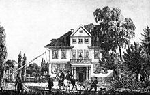
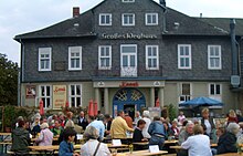
The large Weghaus and rococo pavilion mark the end of the earlier Baroque street that led from Wolfenbüttel.
|
|
Stöckheim is a district in the south of Braunschweig an der Oker , which looks back on over 1000 years of history and has developed from a farming village into an urbanized district in the last hundred years. Before it was incorporated into the Braunschweig urban area in 1974, Stöckheim belonged to the Lower Saxony district of Braunschweig and until 1962 was known as Klein Stöckheim, as a demarcation from today's Wolfenbüttel district of Groß Stöckheim . Stöckheim belongs to the city district 211 - Stöckheim-Leiferde .
geography
Geology and altitude information
Stöckheim is located on the steep east bank of the Oker, which swings extensively to the east between Leiferde and Rüningen and puts the place at an average level of 72 m above sea level. NHN happens. The bank reaches about 75 m at the medieval church built directly on the river. The floor of the Stöckheimer Flur is determined by the loess-covered lower terrace of the river, which extends eastward between the chalk formations of the Lechlumer Holz in the south and the northern Ice Age deposits near Melverode and gently rises to over 80 m in the direction of Mascherode. In the direction of Salzdahlum , the area at Heinebecksberg reaches a height of 122 m. In terms of nature, this hollow belongs to the hill country of East Brunswick , the Okeraue to its sub-area Börßum-Braunschweiger Okertal .
Location and land use
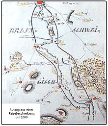
The water seeped into the karst chalk-limestone formations emerges in the Mascheroder Spring and other ditches and mainly strives towards Stöckheim. Today the Siekgraben as well as a creek not named on the maps, which flows through the ponds of the Schriftsassenhof, are visible above ground. The northern Springbach forms the border with Melverode , which is connected to Stöckheim via the historic trunk road from Braunschweig via Wolfenbüttel to Leipzig. The centers of Braunschweig and Wolfenbüttel are about 6 km from the Stöckheimer Markt.
The neighboring towns on the left bank of the Oker are Leiferde and Rüningen, to which an Oker bridge leads each. The Stöckheimer Flur stretches mainly to the east in the direction of Mascherode, where the Stöckheimer Forest is located in continuation of the Lechlumer Holz. In this is the natural monument ND-BS30, a winter horsetail-oak-hornbeam forest. The fertile loess soil is now used for growing wheat and beet, the moist meadows in the Okeraue for cattle breeding. A large part of the agricultural area has been built on with residential buildings since the 1930s and with blocks of flats since the 1960s, with the settlements developing along the north-south axis. Since the construction of the federal autobahn 395 (today's federal autobahn 36 ) towards Bad Harzburg in the 1960s, it has formed the eastern and south-eastern boundary of the settlement. In the south, Stöckheim shares a border with Wolfenbüttel.
history
Traces of prehistory and early history
Numerous traces of settlement have been found in the Stöckheimer Flur, dating back to the Neolithic about 5000 years ago and even further back. One area of discovery is the area close to the Oker and a little higher up on Quaelenberg north of the old town center at the height of Rüningen, after which a street is named. Further areas are located south of the road to Leiferde, on the slope of the Schieferbergs and in the small desert Mark tubs directly in front of the Oker Bridge and desert Mark on the slope by the motorway. The Mark desert was evidently inhabited until the 14th century. Equipment from the time of the birth of Christ and from the Merovingian period was also found there. A continuous settlement since the Bronze Age could not be proven. In the center of Stöckheim there are finds from the Roman Empire at the Protestant church and on Bornstedt's private property from the 5th to 6th centuries.
In addition to the above-mentioned north-south trunk road on the right of the Oker, Stöckheim is also located on a historic west-east connection. After Leiferde, the Okeraue narrows at the Wüsten Mark , so that a river crossing was already possible here earlier. This path, which is also called Deiweg on the western edge of Leiferdes and points to an old road , connects the Steterburg monastery with Salzdahlum.
First mention and name
The first written mention of Stöckheim can be found in Heinrich II's royal charter from 1007 under the name Stokkem . The place name is often present in the region and beyond (Groß Stöckheim, Flachstöckheim and other places that have become desolate). Bornstedt refers to the similar location of these places on a high river bank with coppice use . "Stock" is derived from the Old High German stoc , which means "stick, bar, tree stump". Alder trees and willows were probably the preferred choice for stick rash on the Oker. A similar name explanation is given in the article on Flachstöckheim from the literature. Another interpretation derives the name from the English term "stock" for storage space. In the traditions, the name variant Capelstockem appears, which Bornstedt traces back to the word chapel and this in turn to the church and the possessions of the Steterburg monastery mentioned since 1244. The place name book for the city of Braunschweig rejects this and derives it from the Middle Low German word kavele for “ prepared wood for loosening ” or “willow rod”. There, the phonological development of the umlaut ö as a specific East Westphalian language variant is presented. The derivation of the place name from the term for storage space is discarded.
For centuries the place was called Klein Stöckheim as a distinction to the nearby Groß Stöckheim. The name change from "Klein" Stöckheim to "Stöckheim" took place on August 9, 1963, probably at the instigation of the company Agfa-Gevaert, which was then based there .
The farming village until the Thirty Years War
The location of Stöckheim an der Heerstraße between the city of Braunschweig, which was striving for independence in the late Middle Ages, and the ducal residence city of Wolfenbüttel, almost regularly led to sieges, pillage or the forced supply of mercenaries. Heinrich the Lion already led his troops against the neighboring town, which was then ruled by Gunzelin von Wolfenbüttel . In 1432 it was the descendants of Heinrich, the brothers Wilhelm the Victorious and Heinrich the Peaceful , who fought over the inheritance. The Braunschweiger, who were fighting on Heinrich's side, burned down Stöckheim. In 1531 the Lutherans of the Schmalkaldic League fought on Braunschweig's side against the Catholic Wolfenbüttel, from which Stöckheim was not spared. In the Thirty Years' War the siege of Wolfenbüttel in 1627 with the construction of an Okersta dam, the Schwedendamm, has been handed down, in which the 12,000-strong Pappenheim troops chose Stöckheim as their headquarters. In 1641 the devastation of Stöckheim and Melverode was so lasting that the pastor at the time sought refuge with the village children in Braunschweig.
The old way and the baroque street
After the Thirty Years' War, Duke Rudolf August von Braunschweig-Wolfenbüttel conquered the city of Braunschweig in 1671. He then moved his residence from Wolfenbüttel to Braunschweig and around 1680 had a completely new boulevard built as a connecting route between the two residences, the so-called Herrschaftliche Weg , which was later expanded into Barockstraße .
Old way
Coming from Melverode at the height of today's Hopfenkamps, the former Heerstraße bend to Rüninger Weg and crossed the Hohe-Wiese-Bach that used to flow there . This section can still be recognized today by the conspicuously diagonal south border of the old cemetery, which was west of the old road. This led on to the Alter Weg through the historic town center and the Stöckheim-Süd building area in the direction of Feldmark and has been preserved there as a farm road. To the south of the autobahn, which is interrupting the way today, we passed the High Court along the Lechlumer Holz towards Wolfenbüttel. There, too, the street is called Alter Weg, as a distinction to the Neue Weg. The route, which in 1752 was still mapped as "Damm and Heerstraße to Wolfenbüttel", lost its importance for supra-regional traffic after the rulership was released and was called Dorfstraße in Stöckheim until it was incorporated.
Great way home
Duke Rudolf had a dead straight path laid across the Lechlumer Holz parallel to the old Heerstraße, which was blocked off with barriers on both sides and reserved only for the ducal family. In Stöckheim, the route ended at the Großer Weghaus, which was designed as a customs and guest house in 1691 and which the stately guests could enter with their coaches. To the east of it was a baroque garden, which is indicated by the current street name Am Weghausgarten. On the north side of the Weghaus, the street was continued in a straight line in today's Leipziger Straße and connected to the old Heerstraße. Shortly after the Weghaus a connecting path led diagonally to the community bakery and further over the shepherd's house on Hohen Weg towards the cemetery and across from today's elementary school at Ütschenpfuhl on Rüninger Weg. Today the first section is still there as a lane called Bäckerstieg. Many years later the Weghaus housed Gotthold Ephraim Lessing during his stays between Wolfenbüttel and Braunschweig and later Wilhelm Raabe with his clothes sellers. Today it is used as a residential and commercial building, artist studio and restaurant.
Star house
In the course of the new path, the Sternhaus, first mentioned in 1687, was built on Wolfenbütteler terrain as a princely pleasure house in the middle of the forest. It owes its name to the eight-beam paths. The house was used as a restaurant and was valued by society at the time. It existed until 1840 as an octagonal half-timbered house with a beer cellar and four entrances. The Sternhaus, which still exists today, was only built after the tram line to Wolfenbüttel opened in 1897 and was also used for many decades. The line was discontinued in 1954 and replaced by a bus service. The house is still available for private parties today.
Antoinettenruh
Although it also belongs to Wolfenbüttel, the Antoinettenruh Castle, which was built in 1733 for the Braunschweig Duke's daughter and later Duchess Antoinette Amalie on the southern edge of Lechlumer Holz, is significant for the ensemble as a whole, although it only existed until 1832. It was oriented to the south to the city of Wolfenbüttel and thus marked the beginning of the Herrschaftliche Weg am Wald.
Fontsassenhof
At the end of the entire “Barockstrasse” ensemble, from 1752 the expansion of the Schriftsassenhof in the immediate vicinity of the Weghaus took place. The written address is already certified for the year 1700 for a Cammer-Rath Müller. The transfer of ownership and rights to the banker Friedrich Ludwig Metzner, whose widow married the Ducal Commissioner Lutterloh in 1763, is attested for 1752 . This was director of the forerunner of the Braunschweigische Staatsbank . It is not certain whether he or the previous owner initiated the expansion of the farm.
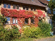
A half-timbered house from 1651 already existed on the property, as the previous owner of which is known as a pig trimmer in 1566, whose 350th anniversary was celebrated in 2001 on the Open Monument Day. The bar inscription shows the year of construction and the owner Johan Iserlok. The house is therefore probably the oldest preserved house in Stöckheim and has been completely integrated into the baroque ensemble. The house is two-story and the upper floor cantilevers over the ground floor on finely designed lugs . The roof is noticeably acute-angled and towers over the immediately adjacent buildings, to which there are no direct passages in the living areas. A special feature is the complete basement in the area close to the oyster. It was used as a warehouse for many years and as a residential building again since the 1970s and has been renovated several times. Like the entire Schriftsassenhof, it is a listed building.
Immediately to the west is a two-storey residential building that merges into the strikingly designed mansion. The style of the facade, especially on the entrance side of the manor house facing Leipziger Strasse, corresponds to the style of the North German Baroque. The interior is already attributed to the Rococo . On the ground floor, the visitor is welcomed in an entrance hall, from which the spacious rooms equipped with chimneys lead off and a generous double curved baroque staircase leads to the upper floor. There, in addition to the living rooms, the centrally located representative master bedroom should be mentioned, which was probably also the residence of stately guests.
A large garden extends to the main street, the former access to which is closed off by a portal with a two-winged gate. Incidentally, the property is separated from Leipziger Strasse with a half-height wall. Towards the Alter Weg, the farm buildings are arranged in the manner of the three-sided courtyard typical of Stöckheim, of which the former stable along the street has a large courtyard entrance. The site is privately owned, the agricultural buildings are used as storage rooms and horse stables.
Baroque garden and rococo pavilion
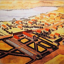
The Schriftsassenhof included a site extending south to today's Leiferdestrasse, which was designed as a large baroque garden with two ponds lying one behind the other. These are still available on the grounds of the farm. They are fed by a stream from the area to the east of the settlements, which crosses Leipziger Strasse directly at the pavilion. The drainage takes place through a pipe to the Oker. The ponds were still used in the 20th century for the rearing of carp and eels. The rest of the former garden area south of the connecting path between Leipziger Straße and Altes Weg is now built on.
In the course of the garden, which is lavishly equipped with bridges and statues, the Rococo pavilion was also built and integrated directly into the wall at the end of the Baroque Street. It is in direct line with the ponds and is accessible from the garden side at ground level. It is two-story, a bay window on the upper floor arches towards the street clearly over the footpath that runs there today. The design has several special features: The floor plan is a skewed rectangle, with the entrance hall opening in a trapezoidal shape to the room and thus providing spatial width despite the wall facing the stairwell. The stairs to the upper floor end in a wooden structure that is perceived in the room as a cupboard between two windows. Incidentally, the upper floor impresses with lush stucco work and a richly decorated fireplace. Martin Peltier de Belfort , who was active at the court of Charles I at the time, is accepted as the architect of the manor house . The stucco work is attributed to Giuseppe Buzzi.
The pavilion was used as emergency quarters after the war and was neglected for many years. In 1989 the city of Braunschweig leased it and had it completely restored by the preservation department. A kitchenette and a utility room with toilets were set up on the ground floor, the stucco work on the upper floor was completely restored and the floor was prepared as an event room. The facade was newly plastered in the upper area and designed in color in accordance with monument conservation guidelines. Since then, the pavilion has been open to the public and is used regularly for cultural events and exhibitions.
Oker shipping and expansion of the Oker
Oker extension 1747
For the upper reaches of the Oker, rafting from the Harz Mountains and freight traffic with boats have been handed down since the 15th century , such as stone transport from Öselberg to Braunschweig. In the 18th century, Duke Karl I made the Oker navigable and in 1747 had the river bank between Wolfenbüttel and Braunschweig cleared for necessary towpaths. Contrary to his earlier approach, the farmers were compensated for the felled willow trees and the abandoned flax rotting. A pier was built in front of the southern city gates of Braunschweig in the Bruch area. A port was built in Stöckheim where the crews of the ships were changed, the street name Am Schiffhorn still indicates this. 489 journeys are documented for 1753, most of which carried beer, bread and building materials. In particular, the beer was demonstrably "nibbled" by ship's crews, which is evident from court records. Shipping was completely uneconomical and was stopped again in 1770.
Oker regulation 1963
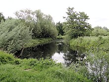
After these significant interventions in the natural river environment, the so-called oker regulation followed almost 200 years later from 1963. In the course of this, three meanders of the Oker were pierced and the course of the river straightened: On the Schiffhorn, the island was created with a side arm still connected to the Oker on one side. This was dredged in 2014 and is to be connected to the river on both sides again. To the north of the church there used to be a sewage treatment plant, there on Bruchweg the Oker was pierced and the area was filled up. Today the AWO kindergarten, the festival meadow and the remains of the sewage treatment plant that serve as a toboggan hill are located here. Another branch is connected to the Rüninger weir on one side with the Oker. Since then, the water that drains off faster due to the straightening of the Ocher has been dammed at the Rüningen weir, which was completed in 1965 and which replaced the old weir of the Rüningen mill . Weirs impair the ecological permeability of the river because they hinder the migration of organisms and animals. The Rüninger weir was equipped with a bristle fish ladder in the 1990s to enable salmon and other fish to migrate. The meadows between the church and Rüninger Mühle are regularly flooded during floods.
Political conditions between 1930 and 1945
In the Free State of Brunswick since the state elections in 1930, a conservative government ruled under Nazi leadership, while the city of Braunschweig and some rural communities still majority chose the SPD and the KPD. In (then still) Klein Stöckheim, 292 SPD and 33 KPD voters were opposed to 112 bourgeois and 62 NSDAP voters in the state elections - a clear left-wing majority. It looked similar in the neighboring villages of Rüningen and Leiferde. The following years in Braunschweig were marked by the massive persecution and suppression of left-wing forces up to bloody terror. Nevertheless, the result of the state elections on March 5, 1933, despite the nationwide seizure of power by the National Socialists, again resulted in a clear majority for Social Democrats and Communists (272 SPD, 51 KPD, 22 DNVP and 162 NSDAP). Dietrich Kuessner describes this day as a “great day in the history of the Stöckheim left”. This time, too, the results in the two neighboring communities were similar.
The Nazis only founded their own local group in the following months. In order to get the political bodies under their control, the state government resorted to a trick: It declared the results of the municipal and district council elections, which were also favorable for the left, to be invalid and stipulated that these bodies would have to be divided according to the composition of the state parliament, different from the outcome of the election. Accordingly, the local group leader Michael Naujok was appointed mayor by the NSDAP district leader Dröge.
At the same time, the parish office of the parish had been occupied by Pastor Willi Kramer from 1929, who showed himself to be a sympathizer of the National Socialists at an early stage and made this public in 1932. In fact, from 1933 onwards, the Braunschweig regional church saw a reversal of church resignations to a significant increase in church members. Obviously, the church was “in” again with the Nazis, but there were always disputes at the local level between the atheist local group leader, who was loyal to the line, and the also National Socialist pastor, who sometimes let the bells ring for days on the occasion of the Wehrmacht victories. He was in office until 1959.
In addition, Klein Stöckheim was directly affected by the war: over 100 prisoners of war and forced laborers, most of whom came from Poland, were quartered in the Großer Weghaus . From 1940 there were air raids and bombings almost every day. On March 31, 1945, the village church was so badly destroyed that it could only be rededicated ten years later. At the end of the war, the last forces were mobilized before the American invasion and the Oker Bridge to Rüningen was blown up, with the buildings of the Rüningen mill being partially destroyed.
Development into an urban city settlement
The population of Stöckheim was less than 600 in 1905. At that time, the village only expanded between Leiferdeweg and the Old Cemetery. In 1939, with the first settlements around Siedlerstrasse, the number of inhabitants rose to almost 1,100 and, due to the strong influx of people after the Second World War, exceeded the 2,000 mark in the 1950s and 4,000 in the 1960s. The status in 2014: over 6,000 inhabitants. The population increased tenfold within a hundred years. Over the decades, Stöckheim was relatively systematically expanded to include individual neighborhoods, with massive blocks of flats also being built in the 1960s at Brauerskamp and Quälenberg and in the 1990s in the Else-Hoppe-Straße area. The rest of the settlement structure is determined by row houses and detached single-family houses. The attractiveness of Stöckheim as a place to live results from its natural location between the city centers of Braunschweig and Wolfenbüttel as well as the very good transport connections by public transport and the motorway. As the population increased, so too did the infrastructure for raising children, retail and traffic, and cemeteries. With the design of the Stöckheimer Markt and the tram connection that took place in 2006, this development was also given an urban development and the location was given a new center.
The Bothner machine factory with 95 employees (today the Am Apfelgarten settlement) and the Matthiesen clothing factory with 160 employees (today the textile retail trade on Mascheroder Weg) appeared as larger business operations and are no longer available today. The settlement of the Gevaert company in 1962 is noteworthy because its buildings were later handed over to the Volkswagen Foundation. It supported the establishment of the Society for Molecular Biological Research, a forerunner of today's Helmholtz Center for Infection Research .
Culture and sights
In addition to the buildings on the historic Baroque Street already mentioned, there are other sights.
Churches
The Evangelical Lutheran Church of the Holy Passion of Christ in Braunschweig is located near the Oker and was first mentioned in a document in 1244. After the war destruction in March 1945, the church building was rebuilt and rededicated in 1955. The church building is characterized by Romanesque window groups. The community belongs to the Parish Association of Braunschweig Süd (since June 2014) of the Braunschweig Provost and runs a kindergarten with a crèche, the modern and light-designed community center at Kirchenbrink is open for cultural activities. Pastor of the pastoral care district is currently Pastor Wiltrut Becker.
The Roman Catholic Church of the Holy Trinity from 1966 is located on Leipziger Strasse. A Catholic parish was formed through the influx of refugees and displaced persons as a result of the Second World War . In 2006 the church came to the parish of St. Bernward in Braunschweig-Heidberg, and since 2013 it has been used by a Syrian Orthodox community.
Yards
There is only one full-time farm in Stöckheim that cultivates the meadows and arable fields and is also known nationwide for its pony breeding. In the old town center there are other typical three-sided courtyards that are no longer used for agriculture. Along the Alter Weg there are several typical half-timbered houses as well as the already mentioned Schriftsassenhof, as well as the Art Nouveau building of the Burgmeierhof, which is popularly known as the beet castle, and which stands out from the village image on the Alter Platz . The name is explained by the relative prosperity that beet farmers used to enjoy. Several three-sided courtyards with their half-timbered houses have fallen victim to the building boom since the turn of the millennium, and especially since 2010, and the plots have been heavily condensed with condominiums.
Water alley
The villagers used to have the right to free access to the river to fetch or wash water there. In addition, the roofs of historical buildings do not drain into a gutter, but into an eaves stone running along the ground or into a sloping trickle. Both can be found in the last preserved Wassergasse immediately adjacent to the Rübenschloss . It actually runs as a public path from the Alten Platz to the Oker, but it is fenced off.
The high court
The former central execution site of the Principality of Braunschweig-Wolfenbüttel is located at the southern end of the Stöckheimer Feldmark, directly on the old Heerstraße in Lechlumer Holz. Today a memorial stone and an information board point to them.
Culture
The Rococo pavilion is used as a venue for smaller exhibitions, readings and demonstrations. The cultural institute of the city of Braunschweig and the association “Kultur vor Ort Stöckheim-Leiferde e. V. ”have been organizing events there and in the parish hall of the Evangelical Church in Stöckheim and in the church in Leiferde since 1993. In addition, there are open family Sundays every year in the form of guided themed bike tours, storytelling walks or other hands-on activities. Several artists and artisans from Stöckheim and Melverode organize a weekend with “open workshops” every year. There are several choirs in Stöckheim. A trombone choir has been active in the Evangelical Lutheran parish since 1995.
Other attractions
In the north of Stöckheim are the Noahs Ark Zoo Braunschweig and the production company of the Braunschweiger Mumme .
The “Winter Horsetail-Oak-Hornbeam Forest” (ND-BS30) is a natural monument in the Stöckheim Forest, which can be easily seen from a forest path.
Infrastructure and club life
Education and Research
The following educational institutions are available in Stöckheim:
- three day care centers
- a primary school
- a secondary school (branch of the Raabeschule grammar school ; former Stöckheim orientation level )
- a local library of the Braunschweig City Library
The Helmholtz Center for Infection Research is located in the east of the town on the federal motorway , and the German Collection of Microorganisms and Cell Cultures is also located on its premises .
traffic
Stöckheim is connected to the federal motorway 36 via the Braunschweig-Stöckheim junction . The main traffic axis Leipziger Straße running right through Stöckheim was completely redesigned in 2005 and 2006 in connection with the construction of the tram route.
Stöckheim is connected with the tram line 1 and the bus line 431 in local transport in Braunschweig . You can get to the city center in around 20 minutes with line 1, which runs every 10 minutes via the main station on weekdays . Since October 2008 there is no direct bus connection from Stöckheim to Wolfenbüttel. From October 2009 to June 2010, line 421 operated again between Salzdahlum, Stöckheim and Wolfenbüttel, although it was heavily restricted in comparison to earlier times.
Volunteer firefighter
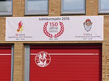
As one of the oldest fire brigades in the former state of Braunschweig and the oldest fire brigade in the city of Braunschweig, the Stöckheim volunteer fire brigade , founded on February 5, 1866, ensures fire protection and general help, especially in its district. On March 30, 1870, the "Klein Stöckheim Fire Brigade" was one of the founding members of the Braunschweig Regional Fire Brigade Association . It currently has the two vehicles TSF-W and MTF , the latter a loan vehicle from the ABC train . Both are used within Stöckheim and also in Braunschweig. Together with the fire brigades from Leiferde , Stiddien , Geitelde and Riddagshausen , the Stöckheim fire brigade forms specialist train 88 of the Braunschweig volunteer fire brigade, which serves as a personnel reserve in the south of Braunschweig.
The youth fire brigade Stöckheim is the second oldest youth fire brigade , after Watenbüttel , in the city of Braunschweig. It was founded for the 100th anniversary on February 1st, 1966. In addition to the youth fire department, Stöckheim has had a children's fire department for children between the ages of 6 and 10 since October 12, 2011 .
Village festivals
For years, the Stöckheimer Volksfest was organized by a working group consisting of a sports club, fire brigade, political parties and local small businesses. Currently, the Easter fire on Holy Saturday and the Stöckheim Advent market on the Saturday before the 1st Advent are just as traditional as setting up a maypole opposite the Stöckheim market.
coat of arms
The coat of arms is divided diagonally and shows a soaring golden lion on a red background in the upper half and a wagon wheel in the lower half.
The lion symbolizes the earlier relationship between the village and the Guelph dukes of the city of Wolfenbüttel, while the wheel refers on the one hand to the old military and trade route that ran from the Harz to Braunschweig and led through the village and on the other hand stands for the Große Weghaus in where the travelers stopped.
Wilhelm Krieg designed the coat of arms and it was adopted by the Stöckheim local council on October 13, 1980.
Personalities
- Wilhelm Bornstedt (* August 16, 1905; † March 28, 1987), 1974 to 1983 city home curator of Braunschweig and home curator of Stöckheim, awarded the Lower Saxony Order of Merit.
- Robert Kugelberg (born January 27, 1886 - † November 20, 1964), politician (SPD), member of the Braunschweig and Lower Saxony state parliaments, district administrator of the Braunschweig district from 1954 to 1956.
- Fritz Lau , District Administrator of the Braunschweig district from 1972 to 1974.
- Günther Müller-Stöckheim (born December 17, 1913 - † July 16, 1943), naval officer.
- Wilhelm Schlueter (born May 11, 1900 - January 26, 1976), politician (SPD), member of the state parliament from 1955 to 1967, district administrator of the Braunschweig district from 1961 to 1963, mayor and honorary citizen of the community of Klein Stöckheim .
literature
- Wilhelm Bornstedt : Chronicle of Stöckheim settlement geography, social and cultural history of a Brunswick village. ACO-Verl. And Druck-GmbH, Braunschweig 1967, OCLC 832954608 .
- Evangelical Church Community Stöckheim (Ed.), Rudolf Zehfuß: 70 years of the end of the war - "Times are coming, times of construction" - The checkered history of the church in (Klein-) Stöckheim , Braunschweig 2015.
- Mathias Haenchen: The Rococo pavilion of the Stöckheimer Schriftsassenhof. Lower Saxony preservation of monuments, special edition Hanover 1992.
- Peter Valentin: 1000 Years of Stöckheim: a contemporary document from 2007. Working group 1000 Years of Stöckheim, Braunschweig-Stöckheim 2006, ISBN 978-3-86611-245-2 .
- Helmut Weihsmann : Building under the swastika. Architecture of doom. Promedia Druck- und Verlagsgesellschaft mbH, Vienna 1998, ISBN 3-85371-113-8 , p. 317.
Web links
- Homepage of the Stöckheim-Leiferde elementary school on grundschule-stoeckheim.de
- History of Stöckheim on braunschweig.de
- Stöckheim fire department
- Local culture association Stöckheim | Leiferde e. V.
Individual evidence
- ↑ Population statistics on braunschweig.de
- ↑ The street to the church is called Kirchenbrink, s. the entry Brink (settlement) and Brinksitzer . The height information is taken from the official maps of the Lower Saxony state survey, topographic map 1: 50: 000, status 2002.
- ^ City of Braunschweig: Umweltatlas Braunschweig January 1998. Map SK70-05 with reference to the source Technical University Braunschweig, Institute for Geology and Paleontology 1989
- ^ Franz Niquet: Prehistory and early history of the Stöckheim district. In: Wilhelm Bornstedt: Chronicle of Stöckheim settlement geography, social and cultural history of a Brunswick village. Braunschweig 1967.
- ^ Bornstedt: Chronicle of Stöckheim settlement geography, social and cultural history of a Brunswick village. P. 66 ff.
- ^ Stock digital dictionary . Retrieved January 26, 2015 .
- ^ History of Stöckheim on braunschweig.de
- ↑ Herbert Blume, Kirstin Casemir and Uwe Ohainski: The place names of the city of Braunschweig (= Jürgen Udolph [Hrsg.]: Lower Saxony Place Name Book (NOB) . Volume 9 ). Publishing house for regional history, Bielefeld 2018, ISBN 978-3-7395-1161-0 , p. 136 .
- ↑ City Chronicle Braunschweig. City of Braunschweig, accessed on May 23, 2017 .
- ↑ according to Rudolf Zehfuß in the Braunschweiger Zeitung of January 21, 2012, Braunschweig local section, p.19. this happened on August 9, 1962
- ↑ Prussian land survey 1752.
- ↑ Map of the village tour. Retrieved January 26, 2015 .
- ^ Bornstedt: Chronicle of Stöckheim settlement geography, social and cultural history of a Brunswick village. P. 98 ff.
- ^ Bornstedt: Chronicle of Stöckheim settlement geography, social and cultural history of a Brunswick village. P. 223 ff.
- ↑ Note: The oldest house after Bornstedt was the Dorfkrug opposite the Schriftsassenhof, which had been attested since 1566 and was demolished in the 1960s.
- ^ Bornstedt: Chronicle of Stöckheim settlement geography, social and cultural history of a Brunswick village. P. 233.
- ^ Bornstedt: Chronicle of Stöckheim settlement geography, social and cultural history of a Brunswick village. P. 231.
- ^ Mathias Haenchen: The Rococo pavilion of the Stöckheimer Schriftsassenhof. Lower Saxony preservation of monuments, special edition Hanover 1992.
- ^ Local culture at Stöckheim / Leiferde. Retrieved December 22, 2014 .
- ^ Bornstedt: Chronicle of Stöckheim settlement geography, social and cultural history of a Brunswick village. P. 194 f.
- ↑ a b c d Dietrich Kuessner : Collection of materials on the history of the Kl. Stöckheimer Dorfkirchengemeinde in the first half of the 20th century , script of a lecture in the Protestant parish of Stöckheim on May 24, 2007, March 2008, p. 7 ff.
- ↑ Evangelische Kirchengemeinde Stöckheim (ed.), Rudolf Zehfuß: 70 years of the end of the war - "Times are coming of collapse, times of construction" - The checkered history of the church in (Klein-) Stöckheim , Braunschweig 2015, p. 16 ff.
- ↑ Stöckheim Church on braunschweig.de
- ↑ Village tour of Stöckheim, 24 Burgmeierhof Ass.26, Art Nouveau villa. Retrieved February 1, 2015 .
- ↑ Operations department - Stöckheim local fire department. In: www.feuerwehr-stoeckheim.de. Retrieved May 18, 2016 .
- ^ Chronicle - Stöckheim local fire brigade. In: www.feuerwehr-stoeckheim.de. Retrieved May 18, 2016 .
- ^ Youth fire brigade - Stöckheim local fire brigade. In: www.feuerwehr-stoeckheim.de. Retrieved May 18, 2016 .
- ^ Children's fire brigade - Stöckheim local fire brigade. In: www.feuerwehr-stoeckheim.de. Retrieved May 18, 2016 .
- ^ Arnold Rabbow: New Braunschweigisches Wappenbuch. Braunschweiger Zeitungsverlag, Meyer Verlag, Braunschweig 2003, ISBN 3-926701-59-5 , pp. 27/28.
- ↑ City Chronicle Braunschweig. Entries for 1976. In: braunschweig.de. City of Braunschweig, accessed on April 1, 2011 : “26. January 1976 - Wilhelm Schlueter, former member of the Lower Saxony state parliament, member of the district council of the former district of Braunschweig, former mayor and honorary citizen of the municipality of Stöckheim, has died at the age of 75. "


