Geitelde
|
Geitelde
City of Braunschweig
|
|
|---|---|
| Coordinates: 52 ° 12 ′ 35 ″ N , 10 ° 28 ′ 7 ″ E | |
| Height : | 83 m |
| Residents : | 1168 (December 31, 2015) |
| Incorporation : | March 1, 1974 |
| Postal code : | 38122 |
| Area code : | 05300 |
|
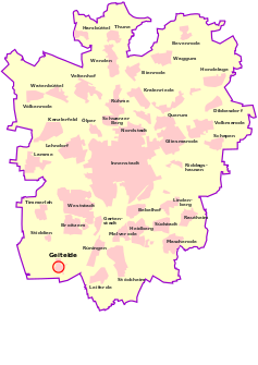
Location of Geitelde in Braunschweig
|
|
Geitelde is located in the extreme southwest of Braunschweig and is one of the smallest districts. The former village was incorporated into the city of Braunschweig in the southeast of Lower Saxony on April 1, 1974 from the Wolfenbüttel district . The proximity to the Salzgitter business location has a positive effect on jobs and the need for building land, so that large building areas have been developed in Geitelde.
The district belongs to the district 222 - Timmerlah-Geitelde-Stiddien
geography
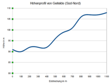
Geitelde is located on the southern slope of Geitelder Berg , which is 111 m above sea level. NHN highest elevation in Braunschweig. It belongs to a chalk formation that extends north over the Steinberg in Broitzem with a height of 106 m and further east to the over 98 m high Westerberg and encloses the Geitelder wood . The Geitelder Holz is one of the most pristine forest areas in Braunschweig and is the headwaters of the Geitelder Graben . A spring gushes in the village, the Wash , which flows off towards the Thiedebach and is the center of the village.
The place is in the immediate vicinity of the A39 running east and the Salzgitter branch canal to the west .
history
Geitelde was created around the year 800 AD, when it was first mentioned in the Fulda Monastery Register of Goods (see Liergau ). In 1885, the largest semi-precious stone ax in Europe was found in the northeastern part of Geitelder Holz . This suggests that Geitelde already existed as a settlement in the Neolithic .
The naming in the course of time: Gedlithi (1060), Getlede (1196), Ghetelde (1304) and later Geitelde . The linguist Herbert flower suggests that the former name Getlithi to the Germanic word Gatil-Lithi can be traced back. This would be a derivation from the water name Gatila , which means something like "the flowing through" and relates to today's washing. At first the parish village was also called " Haufendorf an der Wasche". In the Middle Ages it continued to develop around laundry.
In 1988 pit houses with ceramic finds from the 7th to 9th centuries were unearthed. The village was partially destroyed during the Thirty Years War . The Geitelder Church in the center of the village was built in 1807. The Geitelde, surrounded by arable land, retained its village character until the 20th century.
In the course of the establishment of the " Reichswerke Hermann Göring " in nearby Salzgitter in 1939 , the village lost a third of its agricultural area . The social structure changed as many residents migrated to industry. 25 people died in a bomb attack on January 30, 1944. The place had about 70 bomb craters (some 15 m in diameter). There were at least 320 impacts in the field marrow, with many drainages destroyed. In the diary entries of the farmer Otto Dierling sen. describes the situation. Despite the First and Second World War , the village center was almost completely preserved, except for structural changes.
From 1951 to 1974 Geitelde was the location of the Geitelde radio station .
Until 1974 Geitelde belonged to the Wolfenbüttel district . Since 1985, the Geitelder wood with the surrounding fields has been a landscape protection area. In 1988, during construction work in the parish garden, pit houses with early medieval ceramics were found; they date from the 7th to 9th centuries. At present, there are still six full-time and two part-time or part-time farmers based in Geitelde.
Infrastructure
There is a kindergarten in the village, a leisure club for children and young people of the AWO, a tree nursery, a direct marketer and farm shop, as well as an inn with German cuisine. The local associations such as volunteer fire brigade , rifle club, settler community, sports club and church circles are very popular and are looked after by the “village loyal” citizens.
The 465 bus line to the city center (every 30 minutes) provides good connections to the city center, which is approx. 8 km from Geitelde. Nowadays, more than 1,000 people live in Geitelde and the adjacent development area.
- Bike path between Geitelde and Rüningen
At the end of 2009, the planning approval of the city of Braunschweig for a cycle path between Geitelde and the Rüningen district, two kilometers away , was published and construction work was completed in November 2011. The 1.4 kilometer long cycle path ends at the settlement boundary of both villages and is passable in both directions.
- Internet connection
The town's internet connection has been modernized since 2011. Telekom originally announced that it would expand this with up to 16 MB / s per subscriber. For this purpose, three multifunctional housings with active ADSL2 + technology were planned, which are supplied by a fiber optic long-distance route already running in the village. Another fiber optic line is owned by the local energy supplier. Telekom and Vodafone offer a 250 Mbit / s supply for private households.
coat of arms
The Geitelder coat of arms shows a black harrow on a gold shield, which is arranged below a black shield head with a gold cross.
The cross stands for the connection to Christian institutions in the past of the place, especially to Steterburg Abbey . The coloring is unique in the area of the city arms of the Braunschweig districts and was freely chosen.
It was designed by Arnold Rabbow, based on a drawing by Hedy Keßler. The coat of arms was confirmed on February 20, 1980 by the local council of Timmerlah .
Web links
- Geitelde on Braunschweig.de
- Private website about Geitelde
Individual evidence
- ↑ a b Population statistics on braunschweig.de
- ↑ boundaries of the city districts (valid from 01.11.2011). (PDF; 184.10 kB) City of Braunschweig , November 1, 2011, accessed on August 25, 2014 .
- ↑ Luitgard Camerer, Manfred RW Garzmann, Wolf-Dieter Schuegraf, Norman-Mathias Pingel (eds.): Braunschweiger Stadtlexikon . Joh. Heinr. Meyer Verlag, Braunschweig 1992, ISBN 3-926701-14-5 , p. 83.
- ↑ Herbert Blume : Oker, Schunter, Wabe. In: Braunschweigisches Jahrbuch für Landesgeschichte. Volume 86, 2005, p. 28 ff.
- ^ Official information page of the city of Braunschweig on braunschweig.de
- ↑ City district council: minutes of the meeting of September 18, 2014 , PDF file ( memento of the original of May 18, 2015 in the Internet Archive ) Info: The archive link was inserted automatically and has not yet been checked. Please check the original and archive link according to the instructions and then remove this notice.
- ↑ Follow-up check at Telekom AG on June 22, 2020
- ^ Arnold Rabbow: New Braunschweigisches Wappenbuch. Braunschweiger Zeitungsverlag, Meyer Verlag, Braunschweig 2003, ISBN 3-926701-59-5 , p. 18.


