Heidberg (Braunschweig)
|
Heidberg
City of Braunschweig
|
|
|---|---|
| Coordinates: 52 ° 13 ′ 52 ″ N , 10 ° 32 ′ 21 ″ E | |
| Height : | 87 m above sea level NN |
| Residents : | 7614 (Dec. 31, 2015) |
| Incorporation : | 1934 |
| Postal code : | 38124 |
| Area code : | 0531 |
|
Location of Heidberg in Braunschweig
|
|
|
Heidberg skyline at night, February 2019
|
|
The Heidberg is a district in the south of Braunschweig . It belongs to the city district 212 - Heidberg-Melverode .
geography
Neighboring towns of Heidberg are Melverode in the west , Südstadt in the east, Mascherode in the southeast , Stöckheim in the south and Braunschweig's core town in the north .
history
The construction of a southern city for Braunschweig was planned as early as the 1930s, but it was not until 1958 that construction began with the southern city contract. The designs came from Ernst May . In January 1959, construction work began on the Südstadtsiedlung on the larger eastern areas of the Melverode district, the western part of which remained with Melverode. The eastern part of the initial “Südstadtbauung” became the new Heidberg district with four neighborhoods, which was officially named in 1969.
The name is derived from the Middle Low German word heather, which means a wildly grown forest area that thrives on sandy soil. The name “Heytberg” has already been handed down in a document from 1300. The reference to the probably large population of yew plants can also be interpreted from old field names such as “Ipkenberg” or “Ibenkamp”.
The streets and paths in Heidberg are named after Thüringenplatz, Rostockstraße and Sachsendamm after central German and Pomeranian cities.
Parks and green spaces
In the district is the 24-hectare Heidbergpark with the two-part Heidbergsee , a former gravel pit. To the northwest of the district, across the highway, is Richmond Park . In the south, allotment gardens connect beyond the Springbach .
Economy and Infrastructure
The settlement is a purely residential area with local amenities, churches, childcare facilities, sports fields and schools of all levels.
- traffic
In the west of the Heidberg has a direct connection to the A 36 : Junction Braunschweig-Heidberg ; to the north you reach the A 39 towards Salzgitter after 1000 m and to the northeast the A 39 towards Wolfsburg.
The Heidberg has a tram route that is used by line 2 of the Braunschweiger Verkehrs-GmbH . Heidberg can also be reached by tram line 1. Bus routes 431 and 442 go through the district.
- education
- three day care centers
- a primary school (primary school Heidberg)
- a school center, with a grammar school and a comprehensive school
- a district library
- Churches
- The Evangelical Lutheran St. Thomas Church is located on Bautzenstrasse; it was consecrated in 1989. Before that, the services took place in the parish hall, which was inaugurated in 1967. The community belongs to the provost Braunschweig the national church Braunschweig . The parish pastor is Eckehard Binder .
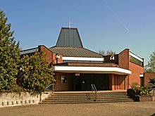
- The Catholic St. Bernward Church is located on Stettinstrasse. It was built from 1968 to 1970, and its parish was founded in 1963. The day-care center of the same name is located next to the church.
- The Stephanus congregation and the kindergarten on Halberstadtstraße belong to the Federation of Evangelical Free Churches ( Baptists ). The church on Dresdenstrasse belongs to the independent Evangelical Lutheran Paul Gerhardt congregation. Viktor Sudermann is the parish pastor .
coat of arms
The coat of arms shows a green yew branch with five red fruits on a white shield ( silver-colored in heraldry ).
The branch is said to stand as a stylized symbol for life, as yew trees can live up to 2000 years. It expresses the wish for a long and prosperous future for this district. The coat of arms was designed by Wilhelm Bornstedt and Arnold Rabbow and confirmed on September 25, 1980 at a meeting of all Heidberg associations.
At the request of a citizens' initiative, the city administration planted several young yew trees in this district.
Web links
- Heidberg on braunschweig.de
Individual evidence
- ↑ Population statistics on braunschweig.de
- ^ A b Arnold Rabbow: New Braunschweigisches Wappenbuch. Braunschweiger Zeitungsverlag, Meyer Verlag, Braunschweig 2003, ISBN 3-926701-59-5 , p. 19.
- ^ Community office: St. Thomas im Heidberg. Retrieved June 24, 2019 .
- ^ Management structure - Stephanus-Online. Retrieved June 24, 2019 .


