Broitzem
|
Broitzem
City of Braunschweig
|
|
|---|---|
| Coordinates: 52 ° 14 ′ 4 " N , 10 ° 28 ′ 51" E | |
| Height : | 83 m |
| Residents : | 5960 (December 31, 2017) |
| Incorporation : | March 1, 1974 |
| Postal code : | 38122 |
| Area code : | 0531 |
|
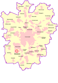
Location of Broitzem in Braunschweig
|
|
Broitzem is a district and urban district of Braunschweig , six kilometers southwest of the city center. Broitzem has 6,145 inhabitants. The district also forms the district 223 - Broitzem.
geography
The place is located between the Fuhse Canal in the north and the Steinberg in the south. Neighboring districts are Weststadt in the north, Stiddien in the west , Rüningen in the east and Geitelde in the south .
history
|
|
|
|---|---|
| The first cartographic representation of Broitzem in the official atlas of the Principality of Braunschweig-Wolfenbüttel by Gottfried Mascop , 1574. |
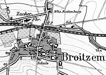
The place was first mentioned in 1160 as Brochem . This name is derived from bro k for "moist meadow" and hem , which should stand for "settlement". In 1179 the place is mentioned as bread seed and 1552 as Broizem . Due to the proximity to Braunschweig, parts of the Broitzemer lands were included in the Braunschweiger Landwehr from 1384 , while the place never became part of the Landwehr. At the end of the 18th century the place had about 400 inhabitants. The larger farms were located in the old town center north of the church, while the farm workers had settled west of the town center. The church building from 1469 to 1480 was rebuilt between 1792 and 1797 by the chamber builders Heinrich Ludwig Rothermundt and Martin Carl Jakob Fricke.
From around 1850, a sugar factory and a brick factory settled in the village. Smaller craft businesses were also added.
In 1916 a military airfield was built in the area of what is now Weststadt , on which Lufthansa trained pilots from 1929 to 1934. From 1934 to 1945, formed Air Force where paratroopers from. Remnants of these systems can be found in today's Weststadt (barracks area Ludwig-Winter-Straße).
In 1934, the part of the municipality north of the Hanover – Braunschweig railway line was incorporated into Braunschweig. The place followed in 1974. The previously independent municipality Broitzem was merged into the city of Braunschweig.
politics
coat of arms
Blazon : "A golden Greek cross in blue , each arm end decorated with a golden lily above ."
The lily cross is derived from the former noble family of the von Broitzem , who carried a similar red cross in silver as their coat of arms. They had named themselves after this place since the 14th century and were patricians in the city of Braunschweig. There, however, their line died out around 1800. The colors blue and gold stand for the former state and the district of Braunschweig . A coat of arms of those von Broitzem is on the Andreaskirche in Braunschweig.
It was designed by Arnold Rabbow and approved by the local council on February 6, 1980.
- economy
In addition to a wide range of retail options, a large number of small businesses have settled in Broitzem.
traffic
- Rail: The Braunschweig – Hanover railway runs in the north, there is no longer a train station in Broitzem.
- Road: Connections to Weststadt, to Stiddien and Rüningen.
- Public transport : Broitzem is served by tram line 5 as well as bus lines 465 and 485 of the Braunschweiger Verkehrs-GmbH .
- Bike: Since June 20, 2010 there has been a one-sided bike path between Broitzem and Stiddien, which was built due to citizen voices from the residents.
Sports
The following sports clubs are based in Broitzem:
- The sports club Broitzem from 1921 e. V., with the departments of football, table tennis, aerobics, children's gymnastics, ladies' gymnastics and mother / child gymnastics. The first senior men's team of SV Broitzem managed to win the German senior men's championship in 2008.
- The Schützenverein Broitzem from 1957 eV, including shooting sports and archery.
Buildings
- Water tower
On the Steinberg, at an altitude of 102.70 meters above sea level, a water tower was built in 1957. After it became superfluous for the use in the context of the water supply due to improved pump systems, it was converted into a residential building from 1994–96.
- Telecommunications tower
There is a Deutsche Telekom transmitter on the Steinberg . The telecommunications tower ( 52 ° 13 ′ 37.13 ″ N , 10 ° 28 ′ 27.26 ″ E ) was built in 1971 and raised to its current height of 154.65 m around 1987 as part of the introduction of private radio. This makes it the second tallest structure in the city. The operating floor is 78 m above the ground. The tower is used for radio relay purposes as well as for broadcasting radio and TV programs.
- church
The Reconciliation Church in Broitzem was built in the years 1469-1480.
Personalities
- Gustav Harms, honorary citizen of the Broitzem community
- Dorette Mundt, honorary citizen of the Broitzem community
literature
- Family Sheets Broitzem. Leipzig 1995. 2 part volumes, 1051 families in the period 1752–1875, according to the inventory part IV of the German Central Office for Genealogy , p. 253
Web links
Individual evidence
- ↑ a b Population statistics on braunschweig.de, accessed on July 29, 2018
- ↑ boundaries of the city districts (valid from 01.11.2011). (PDF; 184.10 kB) City of Braunschweig , November 1, 2011, accessed on August 25, 2014 .
- ↑ Information board in front of the church in the area Große Grubestrasse on the corner of An der Kirche , read on March 23, 2010.
- ^ Arnold Rabbow: New Braunschweigisches Wappenbuch. Braunschweiger Zeitungsverlag, Meyer Verlag, Braunschweig 2003, ISBN 3-926701-59-5 , p. 17.
- ↑ Official announcement of the city of Braunschweig on the cycle path between Boitzem and Stiddien on braunschweig.de


