Schunteraue
|
Schunteraue
City of Braunschweig
|
|
|---|---|
| Coordinates: 52 ° 18 ′ 0 ″ N , 10 ° 32 ′ 18 ″ E | |
| Height : | 70 m above sea level NN |
| Residents : | 5497 (December 31, 2017) |
| Postal code : | 38108 |
| Area code : | 0531 |
|
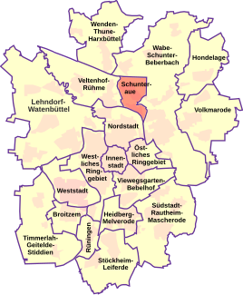
Location of the Schunteraue in Braunschweig
|
|
|
Syltweg, the location of the last gas lamp in Braunschweig
|
|
The Schunteraue is a district (No. 332) of Braunschweig , which includes the districts of Kralenriede and Schuntersiedlung . It borders on Querum to the east . The total population is 5,497. Together with the Nordstadt district , Schunteraue forms the electoral district 42.
history
- Thuringesbutli desert
According to a map of Bornstedt, the Thuringesbutli desert was at the former confluence of the Mittelriede with the Schunter . This confluence was further west than today, namely west of today's Bienroder Weg. The settlement is said to have been built between 500 and 800. It is mentioned for the first time in the Steterburger Annalen (1007) as the Thuringesgibutle and in the dedication certificate of the Magni Church from 1031. there was a watermill here. In 1400 the place was deserted again.
- Districts
The districts that make up the district today did not emerge until the 20th century in the area of the city of Braunschweig. The earliest development of the Kralenriede settlement is documented for 1915, for the Schunter settlement in 1936.
politics
- City District Council
The city district council of Schunteraue has 9 members and has been composed as follows since 2011:
- District Mayor
Gudrun Ohst (since 2001) is the district mayor of the Schunteraue district. Other mayors: Peter Ohst 1981 to 1986, Jürgen Ahrens 1986 to 1996, Peter Olschewski 1996 to 2001.
- Statistical districts
The city district is made up of the following statistical districts:
- Schuntersiedlung (No. 44)
- Kralenriede (No. 45)
coat of arms
The Schunteraue has its own district coat of arms. It combines the five settlements of Schuntersiedlung , Kralenriede , Bastholzsiedlung, Sandwüsten and Michelfelder-Siedlung.
One half of the coat of arms shows five blue wavy bars on a golden background, which symbolizes the settlements in the Schunter area. The second half shows a golden oak leaf on a blue background. This stands for the meadow landscape.
The coat of arms was designed by Peter Ohst and published for the first time in the chronicle of the 50th anniversary of the Schuntersiedlung.
Web links
Individual evidence
- ↑ a b Population statistics on braunschweig.de, accessed on July 29, 2018
- ↑ Map of the electoral districts of Braunschweig ( Memento of the original from February 5, 2013 in the Internet Archive ) Info: The archive link has been inserted automatically and has not yet been checked. Please check the original and archive link according to the instructions and then remove this notice. on braunschweig.de
- ↑ a b Wilhelm Bornstedt : On the document of 1031: The reasons for the entry of the 11th parish villages of St. Magni and their location in today's townscape. A settlement geography; in: Church council to Magni: St. Magni 1031–1981, Braunschweig 1981.
- ^ Arnold Rabbow: New Braunschweigisches Wappenbuch. Braunschweiger Zeitungsverlag, Meyer Verlag, Braunschweig 2003, ISBN 3-926701-59-5 , p. 27.


