
Brunswick Landwehr

.jpg&filetimestamp=20110929193104&)
.jpg&filetimestamp=20110929193012&)
.jpg)
.jpg&filetimestamp=20111001145418&)
The Braunschweiger Landwehr (also: Old Landwehr ) was part of the fortifications of the medieval city of Braunschweig .
.jpg&filetimestamp=20110929192837&)
.jpg&filetimestamp=20111001145618&)
history
In 1376 the city council decided, with the permission of the duke, to build another rampart in the Braunschweig area far in front of the actual city fortifications. At Ölper, the construction of steep earth walls began; sometimes up to three walls ran parallel, which were surrounded by deep trenches.
Where the Celler Heerstraße cut through the Landwehr, the first guard and defense tower was built, the Ölper Tower. Then construction came to a standstill for the time being. In 1384 Duke Friedrich (1373–1400) had the Landwehr built on the initiative of the then mayor Ludolf von Ingeleben. In 1416 the structure was finished with a total of seven guard and defense towers and Bergfrieden .
At the beginning of the 18th century, Duke August Wilhelm had the entire Landwehr repaired and the trenches deepened. In addition, the towers, which are now even more massive, were each given a house and an economy. The travelers were able to take a rest here before moving on to Braunschweig.
At the end of the 18th century, the Landwehr lost its real purpose, the towers gradually passed into private ownership or only served as an inn. On March 9, 1802, Duke Karl Wilhelm Ferdinand gave the order to demolish all of the city's fortifications, including the Landwehr, which in 1809 when the French troops attacked ( battle near Ölper ) almost turned out to be a fatal error.
Importance of the Landwehr
The city of Braunschweig was initially protected by five measures:
- the city wall (remnants of this are visible on Echternstrasse and in the schoolyard of the Kennedy School)
- the inner wall
- the inner flood ditch (still visible today as a mill ditch between Güldenstraße and Petritorwall)
- the outer wall (today parks on the Theaterwall, Museumwall, Petritorwall, Inselwall , ...)
- the outer flood ditch (artificially created course of the Oker , today visible as such).
Another measure was the Landwehr, which drew another ring with a distance of 3 to 10 km around the city center and was thus an important part of the Braunschweig security system. As an outer protective ring, it surrounded Braunschweig and the villages of Lehndorf, Ölper and Melverode as well as some arable and pasture land. It was a difficult belt to overcome for uninvited guests.
At the passageways of the major trade and military roads there were control barriers in front of brick defense towers. From the towers, the Landwehr tower keeper could send optical signals in the direction of the tower keepers of St. Katharinen and St. Martini , who could then arrange for the city gates of Braunschweig to be closed in good time.
In each tower lived a paid guard who checked the passing travelers. In case of danger he secured the road with several thick barriers in order to delay the enemy advance at least a little. In addition, he gave light or horn signals from the tower to the churches of St.Martini or St.Katharinen, which immediately rang the alarm and thereby secured the city gates.
Except as an early warning system or temporary obstacle, the Landwehr had no increased strategic importance. It protected the city from robber barons, unwanted rabble and cattle theft in the city's pastures. It also kept captive mercenary troops out of the city. The Landwehr finally also designated the border of the city of Braunschweig: from here on, armed conflicts got serious.
Like the Landwehr, the towers were subordinate to the Landwehr bailiffs, who had to take care of the maintenance of the facilities. In 1595 there was still a town rider on the stables, who was tasked with constantly checking the land forces.
In addition to the Landwehr towers, there were inns from the start . The Kruger had to keep food and drink ready for those passing through. They also exercised sovereign functions and were therefore sworn in by the city council. You should watch the military forces and keep the barriers closed at night , in crisis situations also during the day. Suspicious people were not allowed to enter. Should the Kruger observe impending attacks against the city, they had to report it to the council immediately.
The stake villages
The area within the Landwehr also belonged legally to the city of Braunschweig, which appointed bailiffs to exercise jurisdiction. The residents had to do manual and clamping services for the maintenance of the land forces, but also beyond that according to the stipulations of the bailiffs . Ölper was obliged to keep the old town free of faeces on a regular basis. Documents have been handed down for the four villages of Rüningen, Lehndorf, Ölper and Rühme, which titled them as "Pfahldörfer". This term probably goes back to the word “piling”.
Course of the Landwehr

The course is primarily characterized by the seven Landwehr towers , which are still known by name and location today: The Rüninger Tower ( ⊙ ) on Frankfurter Straße, the Bergfried Rothenburg ( ⊙ ) near Broitzem , the Repturm ( ⊙ ) an Hannoversche Strasse (B 1), the aforementioned Ölper Turm ( ⊙ ) on Celler Heerstrasse, the Wendenturm ( ⊙ ) in Rühme on Gifhorner Strasse, the Gliesmaroder Turm ( ⊙ ) on Berliner Strasse, the Schöppenstedter Turm ( ⊙ ) on Helmstedter Strasse. From the turning tower , the floodplain of the Schunter to the east and then the floodplain from Mittelriede and Wabe to the south via the Gliesmaroder tower and the Schöppenstedter tower near Rautheim to the field mark border to Salzdahlum formed the landwehr. No special fortifications were necessary here because of the swampy terrain.
From there the Landwehr ran through the Rautheimer Holz to the no longer existing Kleine Weghaus on the way to Salzdahlum and further between Melverode and Stöckheim along the border ditch to the Oker , on the western bank to the Rüninger Tower. The Fuhse Canal (in earlier times also known as Aubach or Landwehr Canal ) formed the Landwehr from there to Broitzem, where the keep of the same name stood on today's street An der Rothenburg .
From there it ran through the Timmerlaher Busch across today's Madamenweg to the Raffurm, further through the Lammer Feldmark (today's new development area Lammer Busch-Ost, see also aerial photo projection below) to the Lammer Holz and parallel to today's Horstbleek to the Ölper Turm and then, after following the course of the Oker a little, it continued over the Münzberg behind the southern exit of Veltenhof, past the Black Mountain and again to the turning tower. The Münzberg and the Schwarze Berg were integrated into the Landwehr system as natural elevations.
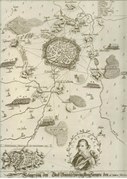
Historical map (1605) with the course of the Landwehr
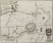
Historical map (1714–1750) showing the course of the Landwehr

Historical map (1894) with the course of the Landwehr at Ölper


Remains still visible today
Remnants of the wall and the trenches are still partially visible today. In Ölper Holz, the oldest and highest preserved wall section runs parallel to the Horstbleek over a distance of 500 m. In Lammer Holz, a remnant runs along the edge of the forest towards the Lammer Busch development area. A striking double rampart is located in Rautheimer Holz, this stretches from Landwehrstraße in Mascherode through the forest for several kilometers to the honeycomb and in this section still forms the official border of the city of Braunschweig.

.jpg&filetimestamp=20110929193104)
.jpg&filetimestamp=20110929193012)
.jpg&filetimestamp=20111001145418)
.jpg&filetimestamp=20110929192837)
.jpg&filetimestamp=20111001145618)
Other remains can be found in Mascheroder Holz, Salzdahlumer Holz and between the southern exit of Veltenhof and Münzberg on the Okerufer. The latter, however, are progressively being destroyed by the meandering Oker. Where the ramparts were razed, ditches (Timmerlaher Busch, Fuhsekanal, Springbach between Melverode and Stöckheim) or farm roads (Lammer Busch) still point to the former course of the Landwehr. In Ölper this can be recognized by the street Alte Landwehr , in Mascherode by the street Landwehrstraße . In the vicinity of the former location of the Rüninger Tower, street names such as Am Turmsberg or Im Turmswinkel indicate the location of the watchtower there. The former Rüninger customs and military building is now on the old town market . The A 39 runs at its original location today .
At the Ölper Turm, Raffurm, Schöppenstedter Turm and Gliesmaroder Turm there are or were until recently restaurants of the same name in historical buildings, the restaurant of the Ölper Tower is first mentioned in 1640.
In the past, the remnants of the old Landwehr were disturbed by the construction of the Ölper Knot, the Autobahn 39 to Rüningen and the general settlement construction (Breite Riede, Horstbleek, Am Zoo). In the Lammer Busch-Ost development area, on the other hand, a deliberately undeveloped green strip that runs through the middle of the new development area will indicate the former course of the Landwehr in the future. The clearly visible in front of the building at certain seasons of the air over the Landwehr on the Lammer Feldmark (see aerial projection right) confirms the amazingly accurate for its time mapping the cited here as a historical source Gerlach's Map of the Duchy of Brunswick-Lüneburg (1763-1775) .
There have been no more publications about the Braunschweiger Landwehr itself in the last twenty years. It is largely unknown to the population. In Rautheimer Holz a sign from the home guard indicates the Landwehr, at the remnants on Münzberg you can see a sign saying “Old Landwehr, medieval ramparts 15th century” and its classification as a natural monument.
In order to preserve the memory of the Landwehr in the population, the Rühme culture and development association erected a monument made of sand-lime brick in the park of the Wendenturm in the Braunschweig district of Rühme.
literature
- Hans-Martin Arnholdt, Kirstin Casemir, Uwe Ohainski (eds.): The Gerlach map of the Principality of Braunschweig-Wolfenbüttel (1763–1775) . (= Publications of the Historical Commission for Lower Saxony and Bremen. 235 ). Hannover 2006, ISBN 3-7752-6035-8 .
- Wilhelm Bornstedt : The old military and trade routes in the greater Braunschweig area: Hildesheim, Peine, Schunter, Königslutter, Helmstedt, Schöningen, Schöppenstedt, Grosses Bruch, Oderwald, Wolfenbüttel, Salzgitter and Braunschweig. Braunschweig district, 1969, DNB 456166033 .
- Wilhelm Bornstedt: From the history of Rautheim on the honeycomb. Braunschweig 1977, DNB 820288349 .
- Wilhelm Bornstedt: Chronicle of the pile village Rüningen. Settlement geography, social, cultural and war history of a Brunswick village. Braunschweig 1980, DNB 810660903 .
- Luitgard Camerer , Manfred Garzmann , Wolf-Dieter Schuegraf (eds.): Braunschweiger Stadtlexikon . Joh. Heinr. Meyer Verlag, Braunschweig 1992, ISBN 3-926701-14-5 , p. 140 .
- J. Reissner: The Landwehr in old Braunschweig. In: Braunschweigischer Kalender. 1968, p. 52ff.
- B. Sauerbrey: The military constitution of the city of Braunschweig in the late Middle Ages . (= Braunschweig work pieces. 75). Braunschweig 1989, p. 32 ff.
- B. Sauerbrey: Citizens and city defense - The city defense constitution using the example of Braunschweig. In: M. Puhle (Ed.): Hanse - Cities - Bünde. The Saxon cities between the Elbe and Weser around 1500 . (= Magdeburg Museum Writings. 4). Volume 1, Magdeburg 1996, pp. 182-190.
- HA Schultz: The Landwehr of the city of Braunschweig. Their course in the light of the latest research. In: Braunschweigische Heimat. 3/1954, pp. 73-77.
- G. Spies (Ed.): Braunschweig. The image of the city in 900 years. History and views . 2 volumes. Braunschweig 1985.
- Werner Spieß : Braunschweig in the post-Middle Ages. From the end of the Middle Ages to the end of urban freedom (1491–1671) . 2 volumes. Braunschweig 1966.
- B. Wübbeke-Pflüger: Security organization and defense of Lower Saxony cities at the end of the Middle Ages. In: M. Puhle (Ed.): Hanse - Cities - Bünde. The Saxon cities between the Elbe and Weser around 1500 . (= Magdeburg Museum Writings. 4). Volume 1, Magdeburg 1996, pp. 173-181.
Web links
- The new building area Lammer Busch-Ost on the website of the city of Braunschweig (there: plan of the Lammer Busch-Ost area with a representation of the aisle for Landwehr) ( Memento from July 3, 2009 in the web archive archive.today )
- Gerlach's map of the Duchy of Braunschweig-Lüneburg (1763–1775) in the "Lower Saxony Cultural Heritage" directory, Göttingen State and University Library
Individual evidence
- ^ Manfred RW Garzmann, Wolf-Dieter Schuegraf, Norman-Mathias Pingel (eds.): Braunschweiger Stadtlexikon - supplementary volume. Joh. Heinr. Meyer Verlag, Braunschweig 1996, ISBN 3-926701-30-7 , p. 102.
- ↑ Hans Lindemann: ÖLPER - The history of a Braunschweig stake village . Orphanage printing and publishing house, Braunschweig 1977, ISBN 3-87884-008-X .