
Gathering tower
|
|
|---|---|
| The gathering tower (marked in red). The course of the Braunschweiger Landwehr is marked in blue. |
|
|
|
| The first cartographic representation of the gathering tower on a visual map in the official atlas of the Principality of Braunschweig-Wolfenbüttel by Gottfried Mascop , 1574 |


The Raffurm was one of seven defense towers of the Braunschweiger Landwehr , the medieval, outer fortification of the city of Braunschweig . It was located west of the city limits, on today's Hannoversche Strasse ( Bundesstrasse 1 ) in the Lehndorf-Watenbüttel district .
history
The first documentary mention was made in 1228 as "Rafhoue" (Raffhof), when the Braunschweig patrician family von Luckenum received an allodial property from the Dorstadt monastery as a fief . In 1260, the acquired Cross Monastery yard and lands and used them as Vorwerk .
After the city council had decided in 1376 to build an outer defensive wall with the Landwehr in the Braunschweig area, far in front of the actual city fortifications, the defense tower was built around 1388 or 1391. The tower was supposed to secure the important trade route between the cities of Braunschweig and Hildesheim . In the 17th century, the Raffurm received the right to serve guests on a commercial basis.
At the end of the 18th century the Landwehr lost its military importance. The defense towers, including the raft tower, were razed . The outbuildings went into private ownership and served as an inn and agricultural buildings. As early as the beginning of the 19th century, the Repturm in the Lehndorf district was only described as an isolated tavern with a sheep farm. Today's Raffurm building, built around 1780, was used as an inn until around 2003.
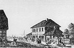
The gathering tower around 1839, engraving by Wilhelm Pätz (1800–1856)

The gathering tower in November 2011
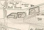
The Raffurm on a map of the city of Braunschweig from 1835
.jpg&filetimestamp=20110929193012&)


literature
- Luitgard Camerer , Manfred Garzmann , Wolf-Dieter Schuegraf (eds.): Braunschweiger Stadtlexikon . Joh. Heinr. Meyer Verlag, Braunschweig 1992, ISBN 3-926701-14-5 , p. 186 .
- Julius Reissner: The Landwehr in old Braunschweig. In: Braunschweigischer Kalender 1968. Meyer, Braunschweig 1968.
- Carl Wilhelm Sack : The fortification of the city of Braunschweig. In: Archives of the Historical Association for Lower Saxony. Historical Association for Lower Saxony (Ed.), Verlag Hahnsche Hofbuchhandlung, Hanover 1847.
- Hans Adolf Schultz : The Landwehr of the city of Braunschweig. Their course in the light of the latest research. In: Braunschweigische Heimat. 40th year, volume 3, E. Appelhans & Co., Braunschweig 1954, pp. 73-77.
Web links
- The Rösturm on the website of the city of Braunschweig , accessed on September 25, 2011.
Individual evidence
- ^ A b Carl Wilhelm Sack: The fortification of the city of Braunschweig . P. 308.
- ↑ August Lambrecht: The Duchy of Braunschweig . Verlag A. Stichtenoth, Wolfenbüttel 1863, p. 338.
- ^ Paul Jonas Meier : The architectural and art monuments of the Duchy of Braunschweig . Volume 2, Herzogl. Braunschweigische Bau-Direction (Ed.), Julius Zwissler Publishing House, Wolfenbüttel 1900, p. 113.
- ^ Johann Ernst Fabri : Geography for all estates . Part 1, Volume 5, Schwickert, Leipzig 1808, p. 486.
.jpg)
Coordinates: 52 ° 15 '36.6 " N , 10 ° 27' 7.2" E