
Ölper tower
|
|
| The Ölper Tower. |


The Ölper Turm is one of the seven former defense towers of the Braunschweig Landwehr , which was built in 1376 as the outer fortification of the city of Braunschweig .
geography
The Ölper Tower is to the west of Kreisstraße 1, which is called Celler Heerstraße in this area, between Bockshorn- and Hirtenweg in the Braunschweig district of Ölper . To the southwest of it are the Ölper motorway junction , which connects the Braunschweiger Westtangente with the Nordtangente , and to the east the Oker and the recreational area around the Ölper See .
history
1388 one was first dungeon in the place mentioned on the Ölper is tower. At that time, however, the place was still called "Elbere". The defense tower was used to monitor trade on what would later become "Celler Straße" or "Celler Heerstraße", which was an important connecting road for the city of Braunschweig to the north and north-west.
In 1413 an approximately 13 m high stone defense tower with a half-timbered structure was built. The tower, the Ölper settlement and the section of the Landwehr in their area were subordinated to the administrative and judicial sovereignty of the Weichbildes Neustadt , to which the Raffurm also belonged. Like other defensive towers, the Ölper Tower was used as an unstitching, guard and customs station. In 1642 the Landwehrschänke was built here, which served as a customs station but also as a meeting place and offered food and accommodation for those traveling through. From 1671 to 1680 the Landwehr fell to Duke Rudolf August when the city of Braunschweig was conquered .
In 1735 the Ölper tower was leased to an innkeeper and the property became private property in 1765. The former defensive tower was demolished in 1825 and a large dance hall was built there. The name "Ölper Turm" was retained for this building complex.
The half-timbered building "Ölper Turm" (formerly Landwehrschenke) built in 1642 is under monument protection, here in particular the two-storey restaurant with a gable roof and the hall extension (dance hall) with a tower top under a hipped roof, which was built around 1830. The former defense tower was also included in the coat of arms of the Ölper district in 1980.
- Views of the Ölper Tower
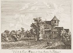
The Ölper Tower around 1786

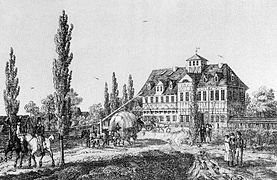
Ölper Turm 1818 with the defense tower demolished in 1825
The Ölper Tower (1839) depiction by Wilhelm Pätz

The Ölper Tower in 2013

.jpg&filetimestamp=20111001145418&)
.jpg&filetimestamp=20110929192739&)

In 1981 Arthur Wiswedel acquired the building from the city of Braunschweig and had it restored according to old plans for several million Deutschmarks. Afterwards, the Ölper Tower with its restaurant was a popular meeting place for citizens of Braunschweig and the surrounding area. The catering business was discontinued in 2005 after a few years. After the Ölper Tower had been vacant for several years, investors were sought in 2015 to renovate the building complex in cooperation with the monument protection of the city of Braunschweig and convert it for residential purposes, so 13 condominiums are to be built. The Ölper Turm GmbH (initially as Ölper Turm UG) was founded for the implementation. The total area is around 1,500 m². Areas between 53 and 178 m² are planned for the apartments.
literature
- Chronicle 750 years of oil drills and stories from our village. Appelhans Verlag, Braunschweig 2001, ISBN 3-930292-52-1 .
- Hans Lindemann: Ölper - The history of a Brunswick stake village. Orphanage printing and publishing house, Braunschweig 1977, ISBN 3-87884-008-X .
- Hans Lindemann: Around the Ölper Tower. A review of the Ölper Chronicle. In: Braunschweigische Heimat. 68, 1982, pp. 51-62, OCLC 833618348 .
Web links
- Brief outline of the history of the tower Where the Oker leaves the city - all houses burned down. to braunschweiger-zeitung.de (restricted access).
- Report of February 9, 2005 on the future of the Ölper Turm restaurant Will the Ölper Turm soon be in new hands? to braunschweiger-zeitung.de (restricted access).
- Pictures of the Ölper Tower and the surrounding area on strassenkatalog.de
Individual evidence
- ↑ Bürgergemeinschaft Ölper - history. bs-oelper.de, accessed on November 22, 2018 .
- ↑ Ölper Turm - individual monument bs-oelper.de.
- ↑ Ölper Turm GmbH, Sickte. northdata.de, accessed on November 22, 2018 .
- ↑ Björn Hinrichs: 13 apartments planned in the Ölper Tower. In: Politik38. wordpress.com, November 21, 2015, accessed November 22, 2018 .
.jpg)
Coordinates: 52 ° 17 ′ 16.4 " N , 10 ° 29 ′ 42.8" E