
Oil lake
| Oil lake | ||
|---|---|---|

|
||
| Lake of Oil, Looking South, 2007 | ||
| Geographical location | Braunschweig , Lower Saxony | |
| Tributaries | Groundwater, Oker in flood, Galggraben | |
| Drain | Oker | |
| Places on the shore | Braunschweig | |
| Data | ||
| Coordinates | 52 ° 17 '16 " N , 10 ° 30' 22" E | |
|
||
| Altitude above sea level | 66 m above sea level NN | |
| surface | 15.85 hectares | |
| length | 800 m | |
| width | 200 m | |
| scope | 2.3 km | |
| Maximum depth | 14.3 m | |
|
particularities |
Quarry pond |
|

|
||
| Sketch of the position of the Ölpersee with the historical oker course | ||

The Ölpersee is an artificial lake in the northwestern urban area of Braunschweig between the Ölper district and the Schwarzer Berg district in the Okeraue .
location
The lake is located in the original river area of the Oker, where it used to branch off into a northern free tide and the southern mill ditch leading to the Ölper Mühle .
The lake is divided into an upper and a lower lake, which are connected by an overflow threshold . The much larger Obersee is about 66 meters above sea level and has a water surface of 14 hectares and a maximum depth of 14.3 meters. The largest extension in east-west direction is about 800 meters. The smaller Untersee is at the same level as the underwater at the Ölper Weir. It is about three meters deep and two hectares in size. It is part of the " Braunschweiger Okeraue " nature reserve and is separated from the public area by a fence and the original Okerlauf on the eastern edge. Its water surface is a fifth of that of the Obersee, its greatest extent in north-south direction is 280 meters.
The lake is filled with groundwater and the surface water of the surrounding settlement. The Galggraben , which is largely canalized and piped in the lake area , brings the water from the settlement area of Hamburger Straße to the east.
In the event of a flood, the Oker will feed the oil lake via an overflow threshold. The down amount can be regulated at the Ölper weir. The discharge takes place via an overflow threshold into the old river bed of the Oker and the Untersee. The two historic branches of the Oker meet north of the Untersee in the Okeraue.
Emergence
In 1974, the city council of Braunschweig decided to create an artificial lake in the Okeraue between Ölper and Schwarzer Berg as part of the construction of the route for the A 391 and A 392 motorways , which should be around 23 hectares in size. In the planning phase it was planned to call it the North Sea , as a counterpart to the South Sea located between Rüningen and Melverode . "In December 1974 the planners decided on the current name."
In the years that followed, sand and gravel were dredged from the floodplain and washed up to form a dam , on which a northern section of the Braunschweig West Tangente (A 391) now runs flood-free. In between, the depth of the lake was up to 25 meters. The original branch of the Oker has been dissolved. The earlier course of the northern free tide is clearly recognizable on the north bank by an offshore island. The entire Oker was "reburied in the old mill ditch which has always run south and west of today's lake and served the water mill in Ölper with 'fuel'".
Originally planned were also playgrounds and sunbathing areas with sandy beaches , a restaurant, a café, a regatta course for rowers and clearance for sailors - but the plans were not implemented. However, on the north bank there is a wooden walkway, a small covered area, a barbecue area, seating and a lawn for sunbathing. The neighboring settlement area Uferstraße with partly makeshift dwellings was incorporated into the local recreation area and some of the houses were demolished.
The Ölpersee Lake was inaugurated on May 24, 1979, and 30 years later its development into an " Eldorado for walkers, joggers, cyclists and water birds" was celebrated on June 21, 2009 with an Ölpersee Festival .
The place

A historical building was integrated into the design of the Ölpersee: The Pfläcknis , the former free flood weir, which relieved the flow to the Ölper Mühle when there was a high volume of water and let the Oker flow into the Osterwiesen Ölpers. Its underwater was the eastern or northern arm of the Oker, which no longer exists today. The time of origin of this weir made of wood is not known, its first mention is passed down for 1727. Other spellings of the name are according to Fläcknis , Flöcknis and many others, although the origin of the name is not clear. The condition still visible today with the side edging made of ashlar dates from around 1800 and is one of the best preserved cultural monuments in the history of Braunschweig. The weir system as well as the historic Ölper weir together with the connecting Mühlengraben have been a listed building since 2003.
Today the weir has no function and is even shielded on both sides from the Oker and the lake. There is only a small pond on the underwater side, which is separated from the lake by a dam. In the picture gallery, old and new views are compared.
Ölper weir

The Ölper Weir was built on the spot where the existence of the Ölper Mühle has been handed down since 1388 . For centuries, this mill was the most efficient mill within the Braunschweiger Landwehr , until it became uneconomical in the 19th century due to the silting up of the underwater and was only continued as a catering business in the following years.
The mill systems were very diverse (grain mills, grinding mills, fulling mills) and had water wheels in two directions: to the north to the original direction of flow of the Oker and to the west. The main stream ran through the area to the west of the weir today and is still bridged today by two wooden structures, one of which contains the weir gate (see picture gallery).
The wheelhouse for the new defense facilities was architecturally sophisticated. A fish ladder was integrated into the weir system. The Ölper weir regulates the water level between Braunschweig city center and Ölper. This is important for the cooling water withdrawal of the Uferstraße thermal power station. With the water level, the amount deposited in the oil lake is also determined.
The flood discharge takes place via an extensive and elaborately constructed threshold. The actual threshold is fixed with paving stones, behind it there is a small recess to accommodate small excess quantities. An elevated wooden plank path has been added to the promenade leading along the threshold. In the event of flooding, it is possible to walk around the lake with dry feet, as the rest of the path is higher than in the threshold area. On the river side of the threshold, stainless steel pipes are mounted so flexibly that they form a barrier for water sports enthusiasts in the event of a flood and prevent them from entering the lake.
Today's meaning
In addition to the flood protection and the bird sanctuary in the area of the Untersee, the Ölpersee is an important local recreation area for the Braunschweiger Nordstadt. It is not intended to be used for water and other sports, but the lake is a popular fishing area. According to information boards, pike up to 1.3 meters in length, catfish up to 1.95 and pikeperch up to 1 meter have been fished there. The biological water quality corresponds to that of the Oker, which is given by the city of Braunschweig as "II to III critically polluted".
Picture gallery

Underwater of the earlier Ölper mill with still existing weir equipment.

Fish ladder at the Ölper weir

Overflow threshold from the Oker (right) to the lake (left). The Oker flows towards the viewer.
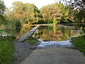
Same situation with floods

Photo of the previous situation at the free flood barrier on one of the display boards of the Bürgererverein Schwarzer Berg e. V. am Ölpersee.

About the same line of sight today.

Different lighting mood at sunset.


Literature and Sources
- Hans Lindemann: ÖLPER - The story of a Braunschweig stake village . Orphanage printing and publishing house, Braunschweig 1977, ISBN 3-87884-008-X .
See also
Web links
Individual evidence
- ↑ H.-J. Tute: Oil Persee. in: Luitgard Camerer , Manfred Garzmann , Wolf-Dieter Schuegraf (eds.): Braunschweiger Stadtlexikon . Joh. Heinr. Meyer Verlag, Braunschweig 1992, ISBN 3-926701-14-5 .
- ↑ a b c Bürgererverein Schwarzer Berg e. V .: Oilpersee culture and educational trail, display boards at the Ölpersee . Braunschweig 2009.
- ↑ Geoportal of the State of Lower Saxony on geolife.de
- ↑ a b c Ernst-Johann Zauner: The Ölpersee should initially be called the North Sea . In: Braunschweiger Zeitung . Braunschweig June 18, 2009, p. 21 .
- ↑ Chronicle. 1970 to 1979 . In: Braunschweiger Zeitungsverlag (Hrsg.): Braunschweiger Zeitung . Braunschweig June 9, 2009, p. 15 .
- ^ A b c Hans Lindemann: ÖLPER - The story of a Braunschweiger Pfahldorfes . Orphanage printing and publishing house, Braunschweig 1977, ISBN 3-87884-008-X , p. 103 ff .
- ^ Monument protection of the city of Braunschweig: Ölper Mühlenwehr, renovation report. Braunschweig 2008, PDF file retrieved from braunschweig.de on September 5, 2013.
- ↑ Water quality map for the sub-catchment area Oker / Schunter-West on nlwkn.niedersachsen.de and water quality on braunschweig.de, accessed on September 5, 2013.
.JPG)
Arboretum | Medicinal Plant Garden | Botanical garden | Bürgerpark | Franz's field | Gaussberg | Green area at the Westbahnhof | Heidbergsee and Park | Hermann-Löns-Park | Inselwallpark | Kennel | Kiryat Tivon Park | Monastery garden | Monastery park | Lion Wall | Museum park | North Park | Riddagshausen nature reserve | Oil Persee | Prinz-Albrecht-Park and Nussberg | Ring track | Richmond Park | School and community garden | City Park | South Seas area | Südstadtpark | Theater park | Vieweg's garden | West Park
Planned: Park on Münchenstrasse | Formerly: Castle Park