Ring track
| Ring track | |
|---|---|
| overall length | 22.5 km |
| location |
|
| map | |
| Places along the way | Braunschweig |
| Flooring | Asphalt, pavement, water-bound ceiling |
| difficulty | light |
| Website URL | ringgleis.de |
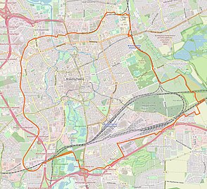
The Ringgleis is a walking and cycling path that leads around the Braunschweig city center over a length of 22.5 km . Most of the route runs on former and alongside existing railway lines . It leads through residential and commercial areas as well as green spaces and networks parks and green spaces.
The first section of the route running in the western ring area was inaugurated in 2003 in the area of the western train station and was initially called the "western ring track". The original idea was to revitalize the fallow land on the disused industrial railway lines, later the concept was also expanded to include the still active lines in order to create an adjacent walkway and bike path. Since December 2019, the Ringgleisweg has enclosed the city center as a leisure route. The sections of the route that currently do not run along the railway line are regarded as "provisional" and should be relocated to the route.
The southern part of the ring track from the Westbahnhof is also part of the Braunschweiger ZeitSchiene project .
history
Ringbahn
The western ring track was part of the route with route number 1903, which was built by the Braunschweigische Landes-Eisenbahn-Gesellschaft at the end of the 19th century . Together with other routes around the Braunschweig city center, it formed an approximately ring-shaped railway system with several stations such as the southern main station, east station, north station and west station. The western track body was used for freight traffic, which was given an important transshipment point at the Westbahnhof and was not shut down until the 1980s. The section previously connected to it in the north by a bridge will continue to be used to supply the central heating and power station and will be approached from the eastern railway lines.
Commitment to conversion
As early as 1995, the Braunschweiger Forum citizens' initiative initiated a discussion about the possible public use of the railway line as an alternative to selling it to private investors. In the following years, the political committees and the public became interested in its use as a walkway and cycle path, and numerous activities were organized around the ring track. In 2001, when the city of Braunschweig incorporated the ring track into the “Socially Integrative City ” program, a concept was developed and implementation planning began.
In May 2011 the city of Braunschweig published a master plan for the ring track. The entire ring track was included in the planning for the creation of a footpath and cycle path around the entire city center of Braunschweig. In the new concept, each section of the ring track is assigned a motto: the western ring track becomes a social track, the southern ring track becomes a rail track, the eastern ring track becomes a park track and the northern ring track becomes a track through technology and nature . The completed Ringgleisweg should cover a distance of around 19 kilometers.
Western ring track and reconstruction of the Westbahnhof
In 2000 the city of Braunschweig bought the first sections of the route from Deutsche Bahn. In 2003, the first four-kilometer section of the footpath and bike path in the western ring area north of the former Westbahnhof was completed. The first clearing work began in 2006 on the site.
In April 2007 the section between Broitzemer Straße and Hugo-Luther-Straße was opened to the public. During the expansion of the Hugo-Luther-Straße-Arndtstraße section, two one-man bunkers were discovered that will be part of the ZeitSchiene in the future. The Braunschweiger ZeitSchiene was opened with the unveiling of the first stone of the decade on April 13, 2008 at Westbahnhof.
Next, the section between Celler Strasse and Ernst-Amme-Strasse was completed, closing the gap up to the Oker.
In autumn 2009, the section from Arndtstraße to Harzstieg in the garden city at the southern end of the ring track was completed and released for driving and walking.
By 2011, the expansion from the Oker in the north across from the Braunschweig-Mitte thermal power station to the Harz + Heide exhibition center in the south. In further construction phases, a new bridge was built over the A 391 and in 2016 the Oker crossing at the thermal power station.
In 2017, the paved section of the western ring track between Triftweg and Kälberwiese was given a yellow coating. This should clearly delimit the ring track from the motor vehicle roads. At the same time, a historical turntable was installed on the site of the Westbahnhof, which was previously located near an industrial building. This had to be dismantled for the construction of the socio-cultural center. The turntable is the only one of its type that is still preserved in Braunschweig.
Southern extension

From spring 2010, the southern extension to the A 391 was built. On April 17, 2010, the old railway bridge over the A 391 was removed except for the abutments. The new pedestrian and bicycle bridge was delivered in two sections and placed over the A 391 with a crane at Christmas 2010. At the end of March 2011, the bridge was opened to pedestrians and cyclists. In the summer of 2011, the connection to the South Sea and Otto-von-Guericke-Strasse was completed on the east side of the A 391. The construction of a new ramp between Frankfurter Strasse and the railway embankment as well as closing the gap to the Harzstieg were the last works in this area and were completed in February 2012.
In autumn 2017, the construction of the extension from the previous end point directly east of the A 391 to the Echo Bridge including a connection ramp to the Kennelweg began and opened on February 21, 2018.
Northern route and crossing of the Oker
The decisive bridge over the Oker was built in 2016 for the planned expansion of the ring track in the northern part to Mittelweg. The railway bridge at the central heating power station, dismantled in 1995, was replaced by a new steel truss bridge and officially opened to traffic on September 19, 2016.
The section between Mittelweg and Luftschifferweg was opened in November 2017. This runs at the Nordbahnhof and through the Nordpark . The park section is called Ballonwiese.
At the beginning of 2018, the section between the Mitte thermal power station and the main fire station or the allotment garden association Hasenwinkel up to Hamburger Straße and the following section on the former premises of the press house between Hamburger Straße and Mittelweg was opened to the public.
At the end of 2018, the section from Luftschifferweg to Bienroder Weg was opened.
Provisional completion
Since December 2019, the Ringgleisweg has been running around the entire city center over a length of 22.5 kilometers. Parts of the route are provisional, mainly in the south and southeast this provisional route does not run directly along the ring track. In the long term, the route is to be laid on the original railway line.
In further steps, sections of the ring track are to be paved.
Planned expansions
A connection from Georg-Westermann-Allee to the main train station is being discussed in the south-eastern section of the ring track . According to the suggestions of the Braunschweig Forum, this should use the former post office track.
See also
Web links
- Official website for the ring track of the city of Braunschweig http://www.braunschweig.de/ringgleis
- Website for the ring track of the Braunschweiger Forum e. V.
- History of the railway line Leaflet for the preservation of monuments of the city of Braunschweig
- Description of the ring track on 'Bahnrassenradeln' Private page with numerous photos and a map
- Map of the ring track on openstreetmap.org
Individual evidence
- ↑ a b c Press release from the City of Braunschweig, accessed on January 3, 2020.
- ^ Website of the ring track , accessed on July 27, 2012
- ↑ Leisure trails according to the Lower Saxony Law on Forests and Landscape Regulations, Part Eight
- ↑ Railway Atlas Germany 2007/2008. Schweers + Wall, Cologne 2007, ISBN 978-3-89494-136-9 , p. 135
- ↑ The history of the Braunschweig ring track. Retrieved February 17, 2016 . Flyer in PDF format on braunschweig.de
- ↑ The Ring Track Project - The Chronicle from 1988. braunschweiger forum e. V., accessed on November 20, 2018 .
- ↑ Socially Integrative City: Project Description Westliches Ringgleis
- ↑ Master plan of the city of Braunschweig for the development of the ring track
- ↑ Description of the ring track at braunschweig.de , accessed on September 19, 2015
- ↑ ( page no longer available , search in web archives: Newsclick: 1.7 million for the western ring area )
- ↑ ( Page no longer available , search in web archives: Newsclick: First one-man bunker saved from Arndtstrasse )
- ^ Chronicle of the city of Braunschweig
- ^ Regional Braunschweig: Western Ring Track: Asphalt now has a yellow coating
- ↑ Regional Braunschweig: "Turntable Westbahnhof" - New attraction on the ring track
- ↑ Braunschweiger Zeitung: New bridge for the ring track is being built
- ^ RegionalBraunschweig: southern ring track from A391 to Echobrücke released
- ↑ Ring track released. City of Braunschweig, archived from the original on September 20, 2016 ; accessed on September 20, 2016 .
- ↑ News38: There is: First section on the northern ring track finished
- ↑ Regional Braunschweig: to "post track" expand the Ringgleis
- ↑ Brunswick Forum: The post track
Coordinates: 52 ° 15 ′ 6.8 ″ N , 10 ° 30 ′ 12.2 ″ E


