Museum park
| Museum park
|
|
|---|---|
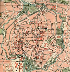
| Location of the museum park on a map of the city of Braunschweig from 1899 |

The Museum Park (sometimes Museum Park ) is a park in the city of Braunschweig .
Geography and equipment
The museum park is located in the east of the city center of Braunschweig, which is enclosed by the Oker river ditch. It is 4.81 hectares. In the east, the museum park borders on the eastern flood ditch. To the north of the park, across the street “Am Theater”, is the Braunschweig State Theater . In the west, the road "Magnitorwall" borders the park. In the south is the eponymous Herzog Anton Ulrich Museum . An underpass east of the theater connects the park with the theater park .
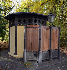
The museum park is characterized by a partly loose, partly denser tree vegetation. These include numerous species that are not native to Germany. In the southeast of the park there is a former ravelin , which, at 80 meters above sea level, is the highest point in the park and around eleven meters above the level of the flood ditch. Other hills are 78 and 76 meters high. The Thuringian Venus statue, created by Gerhard Marcks in 1930 , has been located at the north-western entrance to the park since 2007, near the Great House and the Small House of the State Theater; it was previously in the palace gardens . There is a children's playground in the southwest of the park . On the northern edge of the park is a public urinal with octagonal floor plan and roof skylights from the late 19th century.
history
The museum park is located in the area of the former Ulrich bulwark , which was part of the Braunschweig ramparts . At the beginning of the 19th century, these fortifications were transformed into promenades . Around 1800 the duchess and ruling princess Augusta made the former bulwarks Anton and Ulrich on the eastern flood ditch of the Oker available to the general public. The garden architect Johann George Gottlieb Schoch, who designed parts of the Wörlitz Park , was commissioned with the planning. Under his leadership, the "Duchess Garden", also known as the "Princely Park" or "Ducal Park", was the first Brunswick park in the style of early romanticism . On the east side of the flood ditch, the "Ducal Kitchen Garden " was created as part of the park . After the Duchess moved away in 1805, Peter Joseph Krahe completed the park. The area was divided into wooded hills and flat grassy areas, among other things, and featured a large number of foreign trees. Farm buildings were erected at several points in the park, which were intended to depict the connection between aesthetics and utility in a romantic way, such as a Krahe garden house and a hermitage in an underground natural stone vault. There were several lines of sight in the park . From the park entrance at the “Steintor” you could see the obelisk at the “Löwenwall”. There was a large oval of flowers in the middle of the park. The State Theater was built there from 1858, so that the park was divided into two parts. The northern park was henceforth called the Theater Park. The southern part was reduced in size in 1883 with the construction of the Herzog-Anton-Ulrich-Museum on the southern edge of the park and subsequently referred to as the museum park. The "Ducal Kitchen Garden" was given up in favor of residential development.
In 1949 the Hermitage and the Krahe'sche summer house were demolished. A children's playground was later built in their place. The Schill oak tree has stood in the park since 1959 .
In 1995 further ideas from Schoch were implemented, the entrance at the stone gate was renewed and visual connections were restored. In 2008, the construction of an extension to the museum began and the park area was reduced again.
literature
- Luitgard Camerer, Manfred Garzmann, Wolf-Dieter Schuegraf, Norman-Mathias Pingel (eds.): Braunschweiger Stadtlexikon. Meyer, Braunschweig 1992, ISBN 3-926701-14-5 , p. 228
- Heinz-Joachim Tute, Marcus Köhler: Garden art in Braunschweig. From the princely gardens of the Baroque to the public park of the Wilhelminian era. Braunschweiger Werkstücke, Volume 28, Series A, Braunschweig 1989, ISBN 978-3-87884-037-4
Web links
- Website of the city of Braunschweig on the museum park
- History of the park with a route map
- Description at gaerten-parks.de
Individual evidence
- ↑ a b c Website of the City of Braunschweig on the Museum Park , accessed on July 19, 2011
- ↑ Simon Paulus, Ulrich Knufinke: The Braunschweiger Wallring. Appelhans, Braunschweig 2011, ISBN 978-3-941737-59-4 , p. 121
- ↑ History of the park with paths map , accessed 16 July 2011
- ↑ Ludwig wedding note: Schoch, Johann George Gottlieb. In: New German Biography (NDB). Volume 23, Duncker & Humblot, Berlin 2007, ISBN 978-3-428-11204-3 , p. 349 f. ( Digitized version ).
- ↑ Luitgard Camerer, Manfred Garzmann, Wolf-Dieter Schuegraf, Norman-Mathias Pingel (eds.): Braunschweiger Stadtlexikon. Meyer, Braunschweig 1992, ISBN 3-926701-14-5 , p. 228
Coordinates: 52 ° 15 ′ 52 ″ N , 10 ° 31 ′ 58 ″ E


